GPS coordinates on pesticide application records: what each state requires

TL;DR
- No federal law requires GPS coordinates on pesticide application records.
- But California requires location data precise enough that GPS is the practical way to comply, New York effectively does the same through its specificity rule, and more states are heading that way.
- Requirements range from county-level fields to full GPS polygon boundaries.
- Check your state ag department annually, because these rules change fast.
Does federal law require GPS coordinates on pesticide records?
No. The federal floor for pesticide recordkeeping comes from the Federal Insecticide, Fungicide, and Rodenticide Act (FIFRA) and the EPA's Worker Protection Standard, and neither one asks for GPS coordinates.
FIFRA Section 8 requires certified applicators who apply restricted-use pesticides (RUPs) to keep records for two years. Those records cover the product name, EPA registration number, total amount applied, location of application, crop or site treated, size of area treated, application date, and the applicator's name and certification number. [1] The phrase "location of application" is loose. A farm name or field name satisfies federal law in most states.
The EPA Worker Protection Standard (40 CFR Part 170) requires posting safety information at a central location and giving workers specific field information, but it never mandates geographic coordinates on written records. [2]
So the GPS question is almost entirely a state-level story. A handful of states have stacked precise location requirements on top of FIFRA's floor, and a few now expect full GPS-polygon or GPS-centroid data. The table in the next section maps where things stand right now.
Which states require GPS coordinates or precise location data on pesticide records?
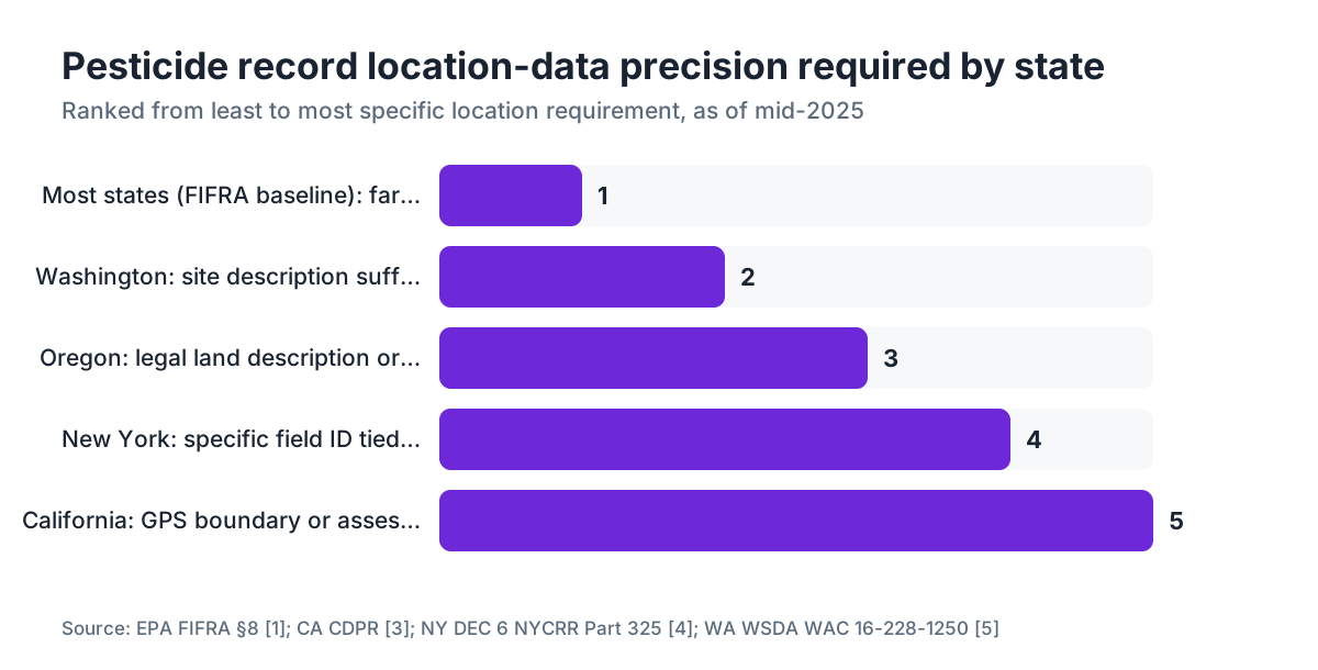
The requirements sort into four rough tiers. "GPS required" means coordinates or a georeferenced boundary are explicitly mandated. "Field ID required" means a named or numbered field tied to a map on file will pass. "County or township" means that level of precision satisfies the state rule. "FIFRA baseline" means the state hasn't gone beyond the federal minimum.
| State | Location precision required | GPS explicitly required? | Key rule |
|---|---|---|---|
| California | GPS-based field boundary or legal parcel | Yes (for most county ag commissioners) | Food & Ag Code §12982; county-specific DPR guidance [3] |
| New York | Specific field ID tied to a dated field map | Effectively yes for commercial applicators | 6 NYCRR Part 325 [4] |
| Washington | Field or site description adequate to locate the area | No explicit GPS, but WSU extension recommends it | WAC 16-228-1250 [5] |
| Oregon | Legal land description or GPS coordinates acceptable | Coordinates accepted, not required | OAR 603-057-0400 |
| Florida | Location by county, section, township, range | GPS not required | 5E-2.030 FAC |
| Texas | Field or site description | GPS not required | 4 TAC §7.24 |
| Michigan | Legal description or GPS encouraged | Not required | MDARD guidance |
| All others | FIFRA baseline (farm name/field name) | No | FIFRA §8 [1] |
This table reflects rules as of mid-2025. State ag departments rewrite pesticide regulations more often than most growers expect, so treat this as a starting map, not the final word.
California is the clear outlier. The California Department of Pesticide Regulation (CDPR) and the county agricultural commissioners who enforce its rules have pushed toward GPS-polygon-level data for more than a decade. Farm in California and you're almost certainly already operating under GPS requirements, whether or not you've framed it that way. [3]
What does California actually require for GPS on pesticide records?
California runs the most demanding pesticide reporting system in the country, and it operates county by county even though CDPR sets the framework. California Food and Agricultural Code Section 12982 requires that every pesticide application to an agricultural commodity gets reported to the county agricultural commissioner. [3]
The exact location format shifts a little from county to county, but the working standard is a GPS-defined field boundary or a legal parcel identifier tied to a county assessor parcel number. Most commissioners' offices now expect applicators to submit location data in formats that are essentially GPS-based: either a centroid (a single lat/lon for the field center) or a polygon boundary.
Ventura, Fresno, Kern, and Tulare counties, all big grape-growing areas, publish applicator guidance that treats GPS centroid submission as the standard. Monterey County, which covers a large slice of California wine grape acreage, has its own commissioner guidance that lists GPS coordinates as the preferred location format.
Here's what that means for a California vineyard. Your pesticide software, whether it's a paper-to-digital workflow or a purpose-built system, has to attach a lat/lon or a polygon to every spray record. A freehand farm map stapled to a paper log no longer satisfies most county commissioners in practice, even if it might technically meet the statute's bare minimum language.
UC Davis Cooperative Extension has published guidance on complying with California's reporting requirements that's worth reading before you set up a new system. [6]
What does New York require for location data on pesticide records?
New York's pesticide recordkeeping rules live in 6 NYCRR Part 325, run by the New York State Department of Environmental Conservation (DEC). [4] Commercial applicators have to record the specific location where the pesticide was applied, with enough detail that a DEC inspector could walk to the exact area.
The regulation never uses the word "GPS." But DEC's own compliance guidance says that for agricultural sites, a field identifier plus a GPS-referenced map on file at the farm is the practical way to meet the specificity requirement. Cornell Cooperative Extension backs this up in its vineyard pest management guides, which recommend attaching GPS coordinates to field records so year-over-year comparisons hold up and DEC compliance reviews go smoothly. [7]
Finger Lakes and Hudson Valley growers should know DEC has stepped up pesticide record audits since 2020. Reports from Cornell extension agents suggest inspectors increasingly ask to see field maps rather than field names. A field labeled "Block 3" with no matching map or coordinates is a soft compliance risk.
The two-year retention requirement matches the federal FIFRA floor. New York adds one wrinkle: records have to be available for inspection within 24 hours of a DEC request.
What does Washington state require for vineyard pesticide records?
Washington's pesticide rules sit in WAC 16-228-1250, enforced by the Washington State Department of Agriculture (WSDA). [5] The rule wants a description of the application site "sufficient to allow the site to be located."
That standard doesn't spell out GPS coordinates. But Washington State University Extension's recordkeeping guidance recommends GPS coordinates or a georeferenced field map, precisely because "sufficient to allow the site to be located" is vague enough to breed ambiguity during a WSDA audit. [8]
Columbia Valley and Yakima Valley managers often run dozens of blocks with similar names. GPS coordinates or block-level polygons are the cleaner fix anyway. They kill the confusion that comes with names like "North Slope Block 2" on farms where the blocks have shifted through years of replanting.
WSDA's retention period is also two years, matching FIFRA. Washington has no county reporting system like California's, so the compliance picture is simpler here. The audit risk from vague location data is still real.
Which states are moving toward GPS requirements in the near future?
Several state ag departments have signaled that tighter location data is coming, even where it isn't law yet.
Oregon's Department of Agriculture has discussed moving to GPS-required formats for its pesticide reporting system, especially for aerial applications. The existing OAR 603-057-0400 already accepts GPS coordinates, so the reporting plumbing is being built now.
Michigan's Department of Agriculture and Rural Development (MDARD) has encouraged GPS coordinates in its applicator guidance since around 2020, framing it as best practice. MDARD staff have said in public meetings that a formal rule update is possible within the next several years.
The EPA has been studying precision agriculture data collection under its FIFRA authority too. A 2023 EPA discussion paper on agricultural recordkeeping modernization named GPS field boundaries as a likely future data element for RUP records at the federal level, though no proposed rule had appeared as of mid-2025.
The takeaway is simple. Setting up GPS-linked records now costs essentially nothing extra if you're digitizing anyway, and it puts you ahead of where the rules are clearly heading.
What information do pesticide application records need to include beyond location?
GPS or not, the FIFRA floor for restricted-use pesticide records includes these fields, all worth capturing even for general-use products: [1]
- Product name and EPA registration number
- Total amount of pesticide applied
- Location of application (farm and field)
- Crop or commodity treated
- Size of area treated (acres)
- Date of application
- Name and certification number of the certified applicator
For general-use pesticides, FIFRA doesn't require written records from private applicators at the federal level. Plenty of states require them anyway. California requires reporting for all agricultural pesticide applications, RUP or not. [3]
Good vineyard practice goes past the legal minimum and adds: product formulation and concentration, application rate per acre, water volume, application method (sprayer type, nozzle size, speed), target pest, PHI (pre-harvest interval) countdown, REI (restricted-entry interval) start and end times, weather at application (temperature, wind speed and direction, relative humidity), and the applicator's signature.
The weather data isn't federally required, but it earns its keep two ways. Drift complaints from neighbors or regulators are far easier to defend against when you have contemporaneous weather records. And for your own IPM program, knowing the conditions around each application helps you read the efficacy results next season.
California vineyards should note that the county commissioner's monthly report form spells out exactly which fields are required. Operators around Paso Robles, for example, can check Paso Robles wineries resources and the San Luis Obispo County agricultural commissioner for local format requirements.
How do you record GPS coordinates for a vineyard block in practice?
Three practical approaches, running from a free phone app to integrated spray software.
The simplest is a GPS app on a smartphone. Walk the block perimeter once and record the polygon, or stand at the center and record a centroid point. Google Maps, ArcGIS Field Maps (free tier), and the USDA's CropScape tool all handle this. Export the coordinates as a decimal degree pair (for example, 38.2974° N, 122.4584° W) or a simple KML file and attach it to your paper or spreadsheet records. Free, and about ten minutes per block.
A step up is dedicated spray record software with GPS-enabled field mapping built in. You draw block boundaries once, store them, and the system auto-populates location data on every spray ticket for that block. Managing more than about 20 blocks, the time savings are real. VitiScribe is one example built for vineyard operators, with GPS field mapping wired into its spray record workflow.
The highest-precision path uses a GPS receiver or a drone-derived boundary from a precision viticulture survey. This gets you sub-meter accuracy, which matters for California's polygon submission format and for any aerial application records where drift liability is on the table.
For most small to mid-size operators, the centroid method (a single lat/lon per block) stored in a spreadsheet or simple database covers every current state requirement except California's most demanding county formats. Polygons are better long term. Don't let the perfect block the compliant.
What are the penalties for missing or inaccurate location data on pesticide records?
Penalties swing hard by state and by whether the violation is a first offense, involves a restricted-use pesticide, or caused environmental harm.
Under FIFRA, civil penalties for recordkeeping violations can reach $5,000 per violation for private applicators and $50,000 per violation for commercial applicators. EPA enforcement guidance stresses that first-time, good-faith recordkeeping failures usually draw warning letters rather than fines. [1]
California enforces hardest. The county agricultural commissioner can issue a Notice of Intent to Assess a Civil Penalty for reporting violations. Penalties under California Food and Agricultural Code Section 12999 reach $5,000 per violation per day for reporting failures. [8] Most first violations end in a compliance meeting and a correction period, not an immediate fine. But repeat violations, or unreported pesticide use near a school or waterway, move toward civil penalties fast.
New York DEC enforcement data shows agricultural pesticide recordkeeping violations account for a meaningful share of annual enforcement actions, with civil penalties in the $500 to $5,000 range common for record deficiencies.
The fine isn't the real risk. A recordkeeping audit that turns up location problems tends to trigger a broader review of your whole system. Once inspectors find trouble in your location fields, they look harder at application rates, applicator certifications, and PHI compliance. Clean location records are part of a defense posture, more than an administrative box to check.
Do organic vineyards have different GPS or recordkeeping requirements?
Yes, and in some ways the bar is higher.
USDA National Organic Program (NOP) regulations require certified organic operations to keep an Organic System Plan (OSP) and field-level records detailed enough for a certifier to verify no prohibited substances touched any certified field. [9] The NOP text never says "GPS." But the field-level specificity it demands in practice means certified organic vineyards need clear, inspectable location data for every input application.
Your certifying agency (one of the USDA-accredited certifiers) may set its own format rules that go beyond the NOP baseline. Some certifiers require GPS coordinates or georeferenced field maps in the OSP to erase any doubt about which parcels are certified and which aren't.
For organic vineyards that also run conventionally managed blocks, GPS boundary data matters even more. An inspector needs to confirm that a conventional pesticide application record lines up with a non-certified parcel, and that the certified parcel boundary doesn't overlap. Without GPS or a very precise map on file, that check is harder to run and harder to defend.
UC Davis's organic farming research and extension group has published guidance on record systems for certified organic operations. [6]
How should you set up a GPS-ready pesticide record system from scratch?
Start with the map. Before you touch software or paper forms, walk every block you manage and set a permanent GPS boundary or centroid for each one. Give each block a short, unique identifier ("Estate-Block-04-Cab" beats "Block 4" when you're staring at records three years later). Record the coordinates in decimal degrees, the universal format every system can read.
Store those coordinates somewhere permanent and easy to reach. A shared Google Sheet, a farm management platform, or a printed GPS coordinate sheet laminated and kept in the spray equipment binder all work. The point is that anyone filling out a spray ticket can find and copy the right coordinates for the block they just sprayed.
Then build your spray record form around those block IDs. Paper, spreadsheet, or dedicated software, the form should ask for block ID first, and the GPS coordinates should fill in automatically (in software) or get looked up from your reference sheet (on paper).
Larger operations get real relief from purpose-built vineyard compliance software, which cuts the manual lookup friction. A tool like VitiScribe auto-populates the GPS coordinate and formats records for California DPR reporting or state-specific layouts, which saves real time across multiple appellations.
Review your location data once a year, minimum. Block boundaries drift with replanting, lease changes, and easement adjustments. A GPS record that was accurate in 2020 might describe the wrong parcel in 2025 if the land moved under you.
Are there federal proposals to standardize GPS requirements for pesticide records?
The EPA has studied this under its precision agriculture and agricultural data initiatives, but as of mid-2025 no proposed federal rule specifically requiring GPS coordinates on pesticide records has appeared in the Federal Register.
The USDA's precision agriculture working groups have discussed GPS-linked pesticide records as part of broader farm data interoperability goals. The 2018 Farm Bill directed USDA to study barriers to precision agriculture data adoption, and several later reports touched on pesticide recordkeeping as a spot where standardized geospatial data would help both compliance efficiency and environmental monitoring. [10]
Industry groups including CropLife America have generally backed voluntary GPS adoption while pushing back on mandatory federal GPS requirements, arguing that farm data privacy has to be sorted out before geospatial pesticide records become a federal mandate.
The likeliest road to broader GPS requirements is state-by-state adoption following California's model, with federal standardization possibly trailing years later. Washington, Oregon, and Michigan look most likely to move first based on current regulatory signals.
WSU Extension's pesticide recordkeeping resources track Washington regulatory updates and are worth bookmarking if you farm the Pacific Northwest. [8]
Frequently asked questions
Does FIFRA require GPS coordinates on pesticide application records?
No. FIFRA Section 8 requires restricted-use pesticide applicators to record the location of application, but that standard is satisfied by a farm name or field description. GPS coordinates are not mentioned in the federal statute. State rules, particularly in California and New York, layer more precise location requirements on top of FIFRA's baseline.
Which state has the strictest GPS requirements for pesticide records?
California. The state's county agricultural commissioner reporting system effectively requires GPS-based field boundaries or parcel identifiers for every agricultural pesticide application. The California Department of Pesticide Regulation's framework under Food and Agricultural Code Section 12982 is more demanding than any other state's current rules, and county commissioners in major wine grape counties expect georeferenced location data.
Do I need GPS coordinates for both restricted-use and general-use pesticides?
Under FIFRA, only restricted-use pesticide records are required at the federal level, and GPS isn't required there either. But California requires reporting for all agricultural pesticide applications regardless of classification, and if your state has a similar all-pesticide reporting rule, the location data requirement applies to general-use products too. Check your state ag department's specific reporting requirements.
Can I use a phone app to capture GPS coordinates for pesticide records?
Yes, and it works well. Free apps like Google Maps, ArcGIS Field Maps, or the iPhone's built-in compass app can capture centroid coordinates accurate to within a few meters. Walk the center of the block, record the decimal degree coordinates, and attach them to your spray record. For California's polygon submission format, a perimeter walk with a GPS app captures the boundary shape.
How long do I need to keep pesticide application records with GPS data?
The FIFRA minimum is two years for restricted-use pesticide records. California's county commissioner reports are public records retained by the county, but you should keep your own copies for at least three years given California's enforcement posture. Certified organic operations typically need records going back through the 36-month transition period. Some states have longer retention periods; Washington and New York both match the two-year federal minimum.
What format should GPS coordinates be in for pesticide records?
Decimal degrees (e.g., 38.2974° N, 122.4584° W) is the most universally compatible format. Avoid degrees-minutes-seconds for records because it introduces transcription errors and isn't directly importable into GIS systems. For polygon boundaries, KML or GeoJSON files work with all modern ag software. California county commissioners' offices accept decimal degree centroids and KML polygon files.
Do aerial pesticide applications have different GPS recordkeeping requirements?
Yes, in most states that regulate them separately. Commercial aerial applicators are already subject to FAA georeferencing requirements for flight paths, and several states require GPS track logs for aerial applications as part of pesticide records. Even where it's not required, GPS flight track data is the most defensible evidence in a drift complaint or enforcement review, so most aerial applicators capture it regardless.
If I lease vineyard blocks, who is responsible for the GPS pesticide records?
The certified applicator who physically makes the application is the primary responsible party under FIFRA. In a lease arrangement, both the applicator and the landowner may need copies depending on state law. California requires the pest control operator or the grower (if self-applying) to submit the county commissioner report. Make sure your lease agreement specifies who handles pesticide reporting and who retains the records.
Does the EPA Worker Protection Standard require GPS location data on records?
No. The EPA's Worker Protection Standard (40 CFR Part 170) requires that workers and handlers receive information about where pesticides were applied, including field location and REI, but the format doesn't require GPS coordinates. The WPS central posting requirement can be satisfied with a field map, a written description, or GPS coordinates, with the applicator choosing the format.
Will GPS pesticide records help me during a crop insurance claim?
Yes, meaningfully. Crop insurance adjusters reviewing a spray program as part of a disease or pest loss claim want to see that you treated specific blocks on specific dates. GPS-linked records prove the application happened where and when you say it did, which accelerates the claims review. USDA Risk Management Agency loss adjustment manuals reference pesticide application records as supporting documentation for multi-peril crop insurance claims.
Are there privacy concerns with GPS pesticide records being public in California?
This is a real issue. California's pesticide use reports submitted to county agricultural commissioners are public records under the California Public Records Act, and the data including location information is compiled in CDPR's public pesticide use reporting database. Some growers have raised concerns about competitors or activists accessing field-level spray data. The location data is at the section or parcel level, not GPS coordinates, in the public database, which provides some buffer.
Does New York require GPS coordinates for vineyard pesticide records in the Finger Lakes AVA?
New York's 6 NYCRR Part 325 doesn't use the word GPS, but Cornell Cooperative Extension guidance for Finger Lakes vineyards recommends GPS-referenced field maps as the practical way to satisfy DEC's specificity requirement. DEC audits of agricultural applicators have increased since 2020, and inspectors routinely ask to see field maps tied to application records. A GPS centroid or polygon for each block is the cleanest approach.
Sources
- EPA, FIFRA Section 8 Recordkeeping Requirements for Certified Applicators: FIFRA Section 8 requires certified applicators of restricted-use pesticides to keep records for two years including product name, EPA registration number, amount applied, location, crop, area treated, date, and applicator certification number.
- EPA, Worker Protection Standard (40 CFR Part 170): The EPA Worker Protection Standard requires posting safety information and providing field application information to workers and handlers, but does not mandate GPS coordinates on written records.
- California Department of Pesticide Regulation, Pesticide Use Reporting: California Food and Agricultural Code Section 12982 requires reporting of all agricultural pesticide applications to the county agricultural commissioner; county commissioners effectively require GPS-based field boundaries or parcel identifiers for location data.
- New York State DEC, 6 NYCRR Part 325 Pesticide Reporting Requirements: New York's 6 NYCRR Part 325 requires commercial applicators to record the specific location of pesticide application with enough detail that DEC inspectors can identify the exact area.
- Washington State Department of Agriculture, Pesticide Recordkeeping (WAC 16-228-1250): Washington's WAC 16-228-1250 requires a description of the application site sufficient to allow the site to be located, with a two-year retention period.
- UC Agriculture and Natural Resources, Pesticide Use Reporting and Compliance Guidance: UC Cooperative Extension has published guidance on complying with California's county agricultural commissioner pesticide reporting requirements, including field location data formats and organic recordkeeping.
- Cornell Cooperative Extension, Vineyard Pest Management and Pesticide Recordkeeping: Cornell Cooperative Extension recommends attaching GPS coordinates to vineyard field records to satisfy DEC specificity requirements and facilitate year-over-year comparisons.
- Washington State University Extension, Pesticide Recordkeeping Requirements: WSU Extension recommends including GPS coordinates or georeferenced field maps in pesticide records because WAC 16-228-1250's 'sufficient to locate' standard is vague enough to create audit ambiguity.
- USDA Agricultural Marketing Service, National Organic Program Regulations: NOP regulations require certified organic operations to maintain an Organic System Plan and field-level records sufficient for a certifier to verify that prohibited substances were not applied to any certified field.
Last updated 2026-07-09