Buffer zone calculations for pesticide applications near vineyard waterways

TL;DR
- Buffer zone distances for vineyard pesticide applications start with the pesticide label, which is federal law, then layer with state and county rules.
- Distances run from 25 feet for some contact fungicides to 300-plus feet for aquatic-toxic insecticides.
- Your correct buffer depends on the product's toxicity rating, application method, wind speed, and the waterbody classification on your parcel.
What is a pesticide buffer zone and why does it apply to vineyards?
A buffer zone is the horizontal distance between the edge of your spray pattern and a defined sensitive area, most often surface water. Inside that zone the label prohibits application, full stop. It's not a best-practice suggestion. Under FIFRA (the Federal Insecticide, Fungicide, and Rodenticide Act), the label is a legally binding document, and spraying inside a prohibited buffer breaks federal law. [1]
Vineyards sit in landscapes full of water. Irrigation canals, seasonal creeks, drainage ditches, wetland pockets at the low corners of blocks. That proximity makes buffer compliance one of the more consequential parts of vineyard pesticide recordkeeping, and one of the most commonly misunderstood.
The core idea is simple. The hard part is that "buffer zone" can mean three different things on the same day. Your label might require 25 feet to protect aquatic organisms. Your state might add a setback for a specific waterbody classification. Your county ag commissioner might layer a local restriction on top. You have to satisfy all three at once, and the longest distance wins.
How is a pesticide label buffer zone calculated?
EPA makes registrants run aquatic exposure models, mainly PRZM (the Pesticide Root Zone Model) and PELMO, to estimate the runoff and drift concentrations reaching water. The label buffer is the distance at which the modeled concentration in an edge-of-field waterbody drops below the acute or chronic toxicity threshold for the most sensitive aquatic organism tested. [2]
For you in the field, this means you read the label, find the environmental hazards section and any buffer zone table, and follow the listed distance. The label tells you what triggers the buffer. Is it any surface water, only "water bodies used for drinking water," or "natural aquatic environments"? Those words matter.
Application method changes the distance a lot. Aerial buffers are usually the largest. Ground boom, air-blast, and hand application each get their own column in many label tables. One product might require 0 feet for hand application and 150 feet for aerial. [3]
Wind speed at application time is the other big variable for aerial and air-blast work. Many labels cap allowable wind at 10 mph near water, and some set a floor too, requiring at least 3 mph to move drift away from sensitive areas. Wind speed and direction belong in every spray record.
Here's a numeric anchor. EPA's aquatic toxicity classification runs from "practically non-toxic" (fish LC50 above 100 mg/L) down to "very highly toxic" (LC50 below 0.1 mg/L). Products in the very highly toxic tier, including many pyrethroid insecticides growers reach for against grape leafhoppers, carry the longest buffers, sometimes 300 feet or more from surface water even for ground boom application. [2]
What are the common buffer zone distances for vineyard pesticides?
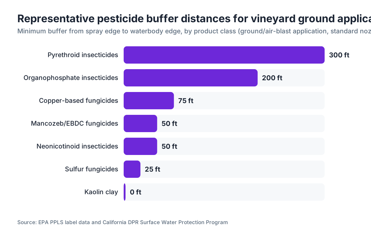
Buffer distances track the product class. The table below groups common vineyard-use products with representative ranges. These don't replace the actual label. They give you a working picture before you open it.
| Product Class | Typical Buffer (Ground/Air-Blast) | Key Aquatic Concern |
|---|---|---|
| Sulfur fungicides | 0-25 ft | Low aquatic toxicity in most formulations |
| Copper-based fungicides | 25-100 ft | Toxic to aquatic invertebrates at higher rates |
| Organophosphate insecticides (e.g., malathion) | 100-300 ft | Moderate to high fish/invertebrate toxicity |
| Pyrethroid insecticides (e.g., lambda-cyhalothrin) | 150-300+ ft | Very high toxicity to aquatic invertebrates |
| Neonicotinoids (e.g., imidacloprid) | 25-75 ft (runoff focus) | Bee toxicity label sections also apply |
| Mancozeb/EBDC fungicides | 25-50 ft | Moderate aquatic invertebrate toxicity |
| Kaolin clay | 0 ft (no aquatic restriction in most labels) | Minimal |
California's Department of Pesticide Regulation (DPR) has surveyed labels for products used on wine grapes in detail. Pyrethroids consistently show the longest distances in that work. [4]
Copper is its own story. WSU Extension guidance notes that repeated copper applications near Pacific Northwest waterways have been linked to sediment accumulation that hurts aquatic invertebrate communities over time, even when growers observed every single-application buffer. That's a longer-term stewardship problem, separate from any one-day compliance check. [5]
How do state and local rules change the buffer distance you actually need?
Federal label buffers are the floor, not the ceiling. Several states run programs that add distance, or bar product use near classified waterways outright.
California layers the most. DPR's Surface Water Protection program flags certain waterbodies as biologically impaired under Clean Water Act Section 303(d) listings. Near those waters, counties can add no-spray buffers or require drift-reducing technology, on top of the label. County Agricultural Commissioners can issue local use restrictions stricter than state or federal rules. Pull your county's current restricted materials permit conditions before the season starts. [4]
Oregon makes applicators check the Pesticide Sensitive Site Registry, which maps aquatic buffers near salmonid-bearing streams. For some pesticides, Oregon adds a 60-foot no-spray buffer from the ordinary high water mark of salmonid streams, regardless of the label. [6]
Washington's Pesticide Management Division, working through the state Department of Agriculture, enforces label requirements and has a real enforcement history around pyrethroid drift into streams in wine grape country near the Yakima Valley. WSU Extension materials for Yakima and Columbia Valley growers recommend 300-foot equipment-free setbacks from irrigation canals for pyrethroids, well past the label minimum. [5]
New York's DEC runs a Pesticide Management Program with mapped no-spray buffers around certain wetlands, and Cornell Cooperative Extension has produced county-by-county guidance for Finger Lakes and Hudson Valley vineyards on reading those maps against specific labels. [7]
So look up three sources: your state ag department, your county ag commissioner, and your state DEQ or DEC. Then apply the longest distance any of them gives you.
How do you physically measure a buffer zone in a vineyard block?
This is where compliance lives or dies. You measure the buffer from the edge of the spray swath, not from the tractor's wheel, not from the vine row. For an air-blast sprayer, the swath edge is the outermost point where droplets are intentionally directed. For a boom, it's the outer nozzle tip.
Three measurement methods hold up in an inspection.
GPS with sub-meter accuracy is common now and easy to defend. Mark the edge of your last spray pass as a waypoint, then measure to the waterbody edge (ordinary high water mark for streams, or the wetland boundary line on your county's mapped resource area). Record both points and the distance in your spray log.
Laser range finders are great for a quick shot along a fence line or row end. They land within a foot or two at typical vineyard distances, plenty accurate for documenting a 100-foot buffer.
Physical markers still win at small vineyards. Stakes or flagging along the row mark your last allowable application point. Measure once per block at the start of the season, place the stakes, and train crews to stop there. Write down the measurement date and method.
For aerial work, the buffer runs from the outermost edge of the target application polygon, not from the aircraft flight line. Your aerial applicator should mark those flight boundaries in their GPS guidance and hand you the logged boundary data as part of their required records. [3]
One warning about waterbody edges. A creek that's bone dry when you spray in August is still a waterbody under most label and state definitions if it flows intermittently. "Surface water" on pesticide labels almost always covers ephemeral and intermittent streams. A dry ditch is not a free pass to skip the measurement.
What role does spray drift play in buffer zone calculations?
The label buffer assumes a modeled amount of drift under defined conditions. Produce more drift than the model assumed, and you're still exposed even if you kept the label distance, because the resulting contamination can support a state water quality action with no label violation at all.
Drift comes down to droplet size, wind speed, boom height (for ground rigs), and nozzle angle. Air-blast sprayers are drift-prone by design. The fan throws droplets up and out, and fine droplets can travel 200-plus feet under 10 mph winds. A Cornell study of air-blast drift in Finger Lakes vineyards measured deposition 150 feet from the sprayer under 6 to 8 mph winds. [7]
Drift-reducing nozzles, air induction tips or flat-fans at larger droplet classifications (ASABE coarse or very coarse), can cut drift 50 to 75% against standard fine flat-fan tips. Some labels explicitly allow a shorter buffer when you use them. Read the buffer table for that option. It can let you apply closer to water legally, as long as you document the nozzle type. [3]
Wind direction matters as much as speed. Blowing toward the water is the worst case. Some applicators time sprays so wind carries drift away from water, which is sound field practice worth noting in your records. It doesn't replace the label buffer distance.
Your spray records should capture nozzle type, nozzle size, application pressure, wind speed and direction at start and end, boom height or air-blast fan setting, and who measured the wind. The EPA Worker Protection Standard, last revised in 2015, requires handlers be trained to use pesticides in ways that protect the environment, and detailed application records are part of showing that training actually happens. [8]
How do you keep buffer zone compliance records that will pass an inspection?
A record that proves buffer compliance holds more than product name and rate. Inspectors from state ag departments and EPA want to see that you knew where the water was, measured the distance, and stayed outside it.
At minimum, any application near water should log the location of the nearest surface water (by name if named, or by GPS coordinate), the measured buffer distance from spray edge to water, the measurement method, and who measured it. Plenty of vineyard managers add a quick sketch map for the first application of the season in each block, showing water features and the no-spray line.
California requires pesticide use reporting (PUR) for all restricted materials and many other products, down to the field level, feeding DPR's statewide database. If your application records don't match your PUR data, that's an automatic red flag in an audit. [4]
Digital systems make this easier. VitiScribe, for example, lets you attach GPS-based water feature layers to block records, so the nearest-water distance flags automatically when you log an application. Software or paper, the standard is the same. If you can't produce the measurement on demand, the record doesn't prove compliance.
Hold records at least two years, the federal minimum under FIFRA. Most state programs want three to five. California requires three years for pesticide use records. [4] Keep application records separate from general farm files so you can pull them fast in an inspection.
What happens if you violate a buffer zone requirement?
Penalties run on two tracks: federal FIFRA violations and state water quality violations.
FIFRA penalties for using a pesticide inconsistent with its label can reach $5,500 per violation per day for agricultural producers, with higher caps for commercial applicators. EPA can assess these without a court proceeding. [1] In practice, a first unintentional violation often draws a warning and a compliance agreement rather than a fine. Documented repeat violations, or a case with actual waterbody contamination, draw serious money.
State water quality violations stack on top. A drift event that puts a listed toxic substance into a 303(d)-listed waterway can trigger a Notice of Violation under the Clean Water Act's NPDES framework, especially if your vineyard holds or should hold a stormwater permit. Clean Water Act penalties for unpermitted discharge can reach $25,000 per day. [9]
The consequences go past fines. Some states suspend restricted materials permits after violations, which can freeze your spray program for a season during permit review. In California, a pesticide use violation can trigger an audit of all your PUR filings for the prior three years.
Then there's civil liability. If a neighbor's fishpond or a downstream water district tests positive for a pesticide traceable to your operation, you face potential tort exposure for damages beyond any regulatory fine.
Are there different buffer zone rules for organic vineyards?
Organic certification doesn't erase buffer obligations. It changes which products you apply, and plenty of OMRI-listed products still carry aquatic toxicity concerns and label buffers.
Copper hydroxide and copper sulfate, staples of organic disease control, carry aquatic invertebrate toxicity concerns and label buffers that typically run 25 to 100 feet depending on formulation and method. Spinosad, used widely for thrips and berry moths, carries a strong bee toxicity warning and some aquatic drift concerns, with label restrictions near water for certain formulations. [10]
The National Organic Program (NOP) under USDA sets no separate buffer distances from water. Those still come from the pesticide label and applicable state rules. Your certifier may write extra requirements into your Organic System Plan, especially if you sit near a certified organic waterway buffer area, but that varies by certifier.
Organic operations do face more scrutiny in one spot: copper accumulation. California DPR has studied copper in vineyard soil and runoff at length. Repeated applications across many seasons can push copper in runoff above aquatic toxicity thresholds even when every single application observed its label buffer. The takeaway for organic growers near water is to track cumulative copper loading, not only per-application compliance. [4]
How does vineyard topography affect buffer zone calculations?
Flat valley-floor vineyards and steep hillside blocks face very different runoff dynamics, and some state programs account for it.
On slopes above about 5%, runoff moves faster and pesticide-laden water reaches stream channels sooner, with less time for soil adsorption to cut the concentration. California's DPR guidance for hillside applications notes that slopes above 5% near surface water may require management measures beyond the label buffer. [4]
Air-blast on steep hillsides is a special case. Topography can angle the fan in ways the flat-field drift models never assumed. Point that fan downslope toward a creek and effective drift distances grow. The right move is to set a larger voluntary buffer than the label requires, write your reasoning into the spray record, and see whether you can shift timing to avoid downslope winds.
Terraced and contour-farmed vineyards can use earthworks to catch runoff before it reaches water. Grassed waterways, rock check dams, and vegetated filter strips at the low edge of blocks all cut actual pesticide loading to streams. None of this reduces your legal buffer, but all of it gives you a real environmental margin if drift or runoff happens. WSU Extension has published practical guidance on filter strip design for Pacific Northwest vineyard conditions. [5]
UC Davis Cooperative Extension has produced watershed-scale modeling for North Coast California vineyards showing that even a 25-foot vegetated filter strip can cut sediment-bound pesticide transport by 50 to 80% under typical winter storm runoff. [11] That doesn't change your label distance. It's a meaningful risk-reduction tool anyway.
What resources help you find the right buffer zone for a specific product?
Start with the physical label. The label you apply under is the one registered with EPA at the time of application. Download it from the National Pesticide Information Retrieval System (NPIRS) or the manufacturer's website. The PDF is the authoritative version. Don't trust a printed container that's more than two seasons old.
EPA's ECOTOX database is a public resource with aquatic toxicity data for active ingredients. It helps you understand why a buffer is what it is, and whether a newer formulation or lower rate would change the picture. [12]
State extension programs carry product-specific guidance.
UC Davis IPM Online posts pest management guidelines for wine grapes with environmental notes by product. They sort products by toxicity tier and include water quality considerations for each recommendation. [11]
WSU Extension's viticulture program publishes annual spray guides for Washington wine grapes with aquatic buffer notes. [5]
Cornell Cooperative Extension's New York viticulture resources address local waterbody concerns for the Finger Lakes and Hudson Valley. [7]
For a fast check on whether a product has known aquatic toxicity concerns, EPA's pesticide registration documents are public via the Pesticide Product and Label System (PPLS). Those include the environmental risk assessments filed at registration, which explain how the label buffer was derived. [2]
If you run multiple blocks with different water exposures, do the efficient thing. Map every water feature at the start of the season, assign a buffer distance to each product class you plan to use, and mark no-spray zones on your block maps before you spray. Do it in a field records system and the information sits in the spray log from the first application, instead of being reconstructed later under audit pressure.
Frequently asked questions
Does a dry creek bed require a pesticide buffer zone?
Yes, in almost every case. Pesticide labels define "surface water" to include ephemeral and intermittent streams, even when they're dry at application time. State water quality programs, including California DPR and Oregon's Pesticide Sensitive Site rules, apply buffers to mapped stream channels regardless of seasonal flow. A dry ditch that flows seasonally is still a waterbody for label compliance.
Can I reduce my buffer zone by using drift-reducing nozzles?
Some labels explicitly allow a shorter buffer when you use ASABE coarse or very coarse droplet nozzles (air induction or similar). Read the label's buffer table carefully, because this option isn't on every product. When it is allowed, document the nozzle type, size, and operating pressure in your spray record. If the label offers no nozzle-based reduction, you can't apply one on your own.
What counts as the edge of a waterbody when measuring a buffer?
For flowing streams and rivers, measure from the ordinary high water mark (OHWM), the line where vegetation and soil show the typical extent of water. For ponds and lakes, measure from the water's edge at normal pool. For wetlands, measure from the delineated wetland boundary. State programs sometimes use different reference lines. Your county ag commissioner or state DEQ can tell you which definition applies locally.
How far must I stay from a vineyard irrigation canal when spraying pyrethroids?
Irrigation canals are surface waters for label purposes. Pyrethroid labels routinely require 150 to 300 feet from surface water for ground application with standard nozzles. WSU Extension recommends 300-foot equipment-free setbacks from irrigation canals in the Yakima Valley for pyrethroids, which often exceeds the label minimum. Check your specific product label, then apply the longer of the label distance and any state or local rule.
Is the buffer zone measured from the tractor or from the spray pattern edge?
Measure from the edge of the spray pattern, the outermost point droplets are directed, not from the tractor or sprayer body. For an air-blast sprayer, that edge is the outermost reach of the fan pattern, not the machine's physical boundary. This distinction can add 5 to 15 feet of effective required setback depending on the sprayer configuration.
Do buffer zones apply to fumigants used in vineyard soil renovation?
Yes. Soil fumigants like metam sodium have their own buffer requirements that address both vapor drift and runoff. Metam sodium labels typically prohibit application within 100 feet of open water and require specific soil moisture conditions to limit volatilization. California adds permit conditions for fumigant use near waterways that go past the federal label. Always check the county ag commissioner's permit conditions for fumigant applications.
How do I document buffer zone compliance in a way that holds up in an inspection?
At minimum, log the name or GPS coordinates of the nearest water feature, the measured buffer distance from spray edge to water, the measurement method (GPS, laser range finder, or stakes), and who made the measurement. For applications near mapped sensitive areas, attach a sketch or GPS track showing the no-spray boundary. California requires field-level pesticide use reports, and your field spray records must match those filings.
What's the penalty for spraying inside a required buffer zone?
Under FIFRA, civil penalties for agricultural producers can reach $5,500 per violation per day. If the application reaches a waterway, Clean Water Act penalties for unpermitted discharge can reach $25,000 per day. State ag departments can also suspend restricted materials permits, which can halt your spray program during review. Repeat violations or documented water contamination draw the most serious enforcement.
Do copper fungicides require buffer zones near vineyard waterways?
Yes. Copper-based fungicides are toxic to aquatic invertebrates, and their labels carry buffers typically running 25 to 100 feet for ground application depending on formulation, rate, and method. Beyond single-application compliance, California DPR has documented that repeated copper applications over multiple seasons can push copper in vineyard runoff above aquatic toxicity thresholds, so cumulative loading is a real concern near water.
Does slope or hillside topography change the required buffer distance?
The label buffer doesn't automatically grow with slope, but California DPR guidance notes that slopes above 5% near surface water may require additional management measures. Steep terrain speeds runoff and can extend effective air-blast drift downslope. Setting a voluntary larger buffer on steep hillside blocks near water, and documenting your reasoning, is a defensible practice that also gives real environmental protection past the minimum.
How often do buffer zone requirements on pesticide labels change?
Labels can change at any EPA registration review cycle, which for many older active ingredients happens every 15 years under the FIFRA registration review program. Some labels change faster on new aquatic toxicity data. Pyrethroids, for example, have had buffer language updated over the past decade as invertebrate toxicity data improved. Always confirm you're applying under the current registered label, which you can check via EPA PPLS or NPIRS.
Are there buffer zone maps I can download for my vineyard's location?
No single national map exists, but several state programs map resources. California DPR's SWIM (Surface Water Impact Mitigation) tool maps waterbodies with added buffer requirements. Oregon's Pesticide Sensitive Site Registry is publicly searchable. New York's DEC maps pesticide buffer areas around regulated wetlands. USDA's Web Soil Survey shows wetland and water feature layers. Start with your state ag department's mapping tools, then cross-reference USGS stream layer data for unmapped features.
Do I need a separate buffer zone for protecting bees versus protecting waterways?
Yes, these are separate requirements that may sit in different sections of the same label. Bee protection buffers usually restrict application timing (no bloom, no foraging period) rather than distance. Aquatic protection buffers restrict the geographic area of application. Both apply at once, and both need to appear in your spray records. Some products, particularly neonicotinoids, carry extensive bee protection language that is more operationally complex than the aquatic buffer.
Sources
- EPA, FIFRA (Federal Insecticide, Fungicide, and Rodenticide Act) overview: The pesticide label is a legally binding document under FIFRA; applying inconsistent with the label is a federal violation subject to civil penalties up to $5,500 per violation per day for agricultural producers.
- EPA, Pesticide Product and Label System (PPLS) and aquatic toxicity classification: EPA requires aquatic exposure modeling (PRZM, PELMO) to derive label buffers, and classifies aquatic toxicity from practically non-toxic (fish LC50 above 100 mg/L) to very highly toxic (LC50 below 0.1 mg/L); very highly toxic products such as pyrethroids carry the longest buffers.
- EPA, Reducing Pesticide Drift, application method and nozzle guidance: Buffer distance varies by application method (aerial, ground boom, air-blast, hand), and drift-reducing nozzles at coarse or very coarse ASABE classifications can cut drift 50 to 75% and may allow a reduced label buffer where the label offers it.
- California Department of Pesticide Regulation, Surface Water Protection Program: California DPR requires pesticide use reporting at field level, mandates three-year record retention, and has documented copper accumulation in vineyard runoff above aquatic toxicity thresholds from repeated applications; slopes above 5% near surface water may require additional management measures.
- Oregon Department of Agriculture, Pesticides Program and Pesticide Sensitive Site Registry: Oregon requires applicators to check the Pesticide Sensitive Site Registry and adds a 60-foot no-spray buffer from the ordinary high water mark of salmonid-bearing streams for some pesticides, independent of the label.
- Cornell Cooperative Extension, New York Viticulture, Spray Drift and Water Quality Guidance: A Cornell study of air-blast drift in Finger Lakes vineyards measured pesticide deposition at 150 feet from the sprayer under wind speeds of 6-8 mph; Cornell Cooperative Extension provides county-by-county buffer zone guidance for Finger Lakes and Hudson Valley vineyards.
- EPA, Worker Protection Standard (WPS), 40 CFR Part 170, 2015 revision: The EPA Worker Protection Standard (last revised 2015) requires that handlers be trained to handle pesticides in ways that protect the environment; detailed application records including wind conditions, nozzle type, and boom height are part of demonstrating compliance.
- EPA, Clean Water Act Section 402 (NPDES) enforcement penalties: Clean Water Act penalties for unpermitted discharge of a pollutant (including pesticides) into waters of the United States can reach $25,000 per day under Section 309.
- USDA National Organic Program (NOP): NOP-allowed pesticides including copper hydroxide, copper sulfate, and spinosad still carry aquatic toxicity concerns and label-required buffer distances; NOP does not set separate water buffer distances, which continue to derive from the pesticide label and applicable state rules.
- UC Davis, IPM Online, Pest Management Guidelines: Wine Grapes: UC Davis Cooperative Extension watershed-scale modeling for North Coast California vineyards shows that a 25-foot vegetated filter strip can reduce sediment-bound pesticide transport by 50-80% under typical winter storm runoff conditions; UC Davis IPM Online posts environmental toxicity notes by product for all wine grape pest management recommendations.
- EPA, ECOTOX Knowledgebase, aquatic toxicity database for pesticide active ingredients: EPA's ECOTOX database provides publicly accessible acute and chronic aquatic toxicity data (LC50, EC50 values) for pesticide active ingredients, which underlie the derivation of label buffer distances.
Last updated 2026-07-10