How to document a new vineyard site assessment including soil survey data
TL;DR
- A complete vineyard site assessment includes a USDA Web Soil Survey report, physical soil texture and drainage tests, climate and frost data, topographic maps, water source documentation, and a pest and disease baseline log.
- File everything before you plant.
- Regulators and lenders both want a paper trail, and a clean site file cuts your establishment risk.
What goes into a vineyard site assessment document?
A vineyard site assessment is a structured record of every physical and environmental factor that decides whether your site can grow wine grapes at commercial quality. It isn't one form. It's a file, built from several data sources, and you'll come back to it for permitting, lender financing, crop insurance, and your own planting calls for years.
The core parts are: a USDA Natural Resources Conservation Service (NRCS) Web Soil Survey report for your parcel, a written summary of on-site soil physical tests, climate and frost data from the nearest NOAA weather station or your own sensor, a topographic or slope map, a water source and irrigation feasibility document, and a pest and weed pressure baseline log. [1]
You also want a legal land description tied to an APN or parcel number, GPS coordinates of every soil sample location, and a narrative that ties all of it together into a site story anyone can read cold. That narrative is what a viticulture consultant, lender, or county ag commissioner actually reads. Make it honest. If the site has a drainage problem, say so and explain what you're doing about it.
California growers should document rootstock suitability right next to soil data, because nematode pressure, phylloxera risk, and pH all interact with rootstock performance. The UC Davis Department of Viticulture and Enology publishes rootstock and soil guidance for exactly this reason. [2] Cornell's viticulture extension for New York takes the same line: cold hardiness zones and frost pocket mapping belong in the site file on day one, not bolted on after you lose a block. [3]
How do you pull soil survey data from USDA Web Soil Survey?
The USDA Web Soil Survey at websoilsurvey.nrcs.usda.gov is free and covers the entire continental US. You draw a polygon around your parcel to define an area of interest, then generate a Soil Data Explorer report. That report gives you map unit descriptions, dominant soil series names, drainage class, available water capacity, cation exchange capacity, and pH ranges for each horizon. [1]
Export the full PDF and save it with your site file. The map unit key (MUKEY) in that report is what ties your parcel to the national database permanently, so put it in your narrative summary. If your parcel straddles two or more map units, document each one separately and note the rough acreage in each.
Web Soil Survey data comes from county soil surveys done over decades, and the spatial resolution is roughly 1:24,000 scale. It can miss variability inside a single block. Treat the output as your starting framework, then verify it with on-site sampling. WSU Extension's Pacific Northwest viticulture resources recommend at least one composite soil sample per 5 acres for new sites, taken at two depths: 0 to 12 inches and 12 to 24 inches. [4]
Write down the date you pulled the report. The underlying data updates periodically. Pull a fresh report three years later and it may read slightly different from what you saw the first time.
What physical soil tests should you run and document on a new vineyard site?
A Web Soil Survey is a map, not a measurement of your actual ground. You need physical samples sent to a certified ag lab. At minimum, document pH, organic matter percentage, texture (sand, silt, and clay percentages), cation exchange capacity, boron, calcium, magnesium, potassium, sodium, and a nematode assay if you're in a region with known pressure. [2]
Beyond the lab work, run a percolation test in the field. Dig at least three test holes to 24 to 30 inches in representative spots. Fill them with water, let them drain, refill, and time the drainage over 30 to 60 minutes. Soil that drains slower than 0.5 inches per hour in the lower profile will almost certainly need subsurface drainage tile or mounding to support healthy roots. Record each hole's GPS location, depth, and measured rate in inches per hour.
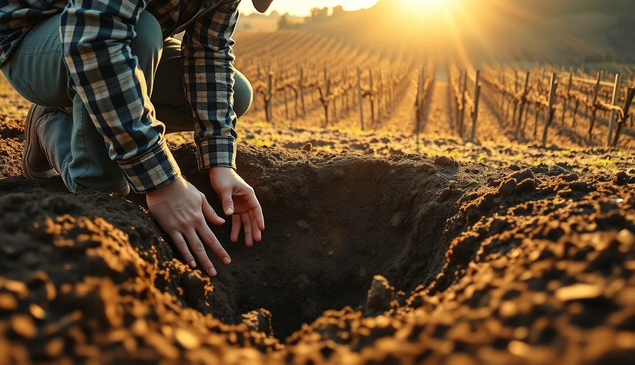
A texture-by-feel test in the field, done horizon by horizon as you dig, takes 20 minutes and costs nothing. Write down what you felt: ribbon length, whether it was gritty or slick. Compare it to your lab texture result. The gaps between the two tell you where the site varies.
Grapevines grow across a fairly wide pH range (roughly 5.5 to 7.5). But boron toxicity, which shows up above about 1 ppm in the saturation extract, and a high exchangeable sodium percentage can shut down a block that looks fine on paper. UC Davis viticulture extension publishes threshold tables for these values specific to wine grape production. [2]
What climate and frost data belongs in a site assessment file?
Climate documentation should include the 30-year climate normals from the nearest NOAA weather station (growing degree days base 50F, mean monthly highs and lows, mean annual precipitation), last and first frost dates at stated probability levels (10%, 50%, and 90% are standard), and any microclimate notes from your own observation or a temporary on-site sensor.
NOAA's Climate Data Online lets you pull station normals and extremes for any US location. [5] Download the CSV, attach it, and note the station ID plus its distance from your site in miles. A station 15 miles away at a different elevation is a rough proxy at best. Even a single season of on-site temperature data from a Kestrel or Davis station is worth documenting, because it catches cold air drainage that regional stations miss entirely.
Frost pocket mapping is one of the most under-documented parts of most site files. Cold air drains downhill like water. The low point of your parcel and the ground behind windbreaks or tree lines can run 3 to 5 degrees F colder than the rest of the block. That gap is the difference between a viable block and a recurring spring frost problem. Walk the site at dawn after a radiation frost and photograph the damage pattern. A dated, geolocated photo is the best frost pocket map you can make.
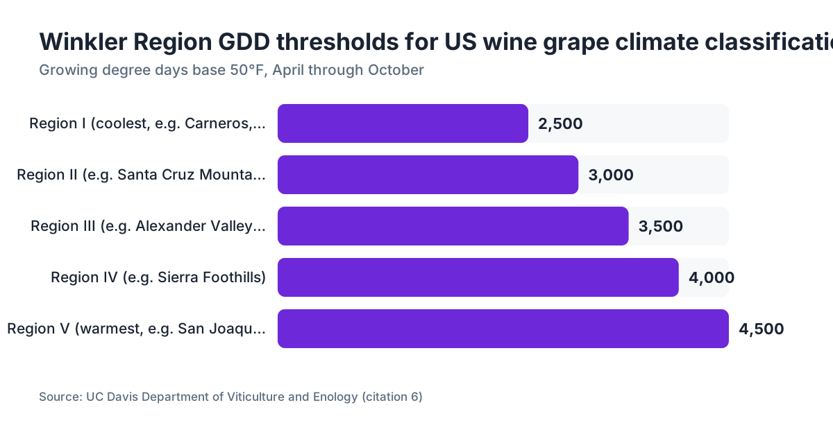
Growing degree day accumulation is how the industry sorts climate suitability by variety. Winkler Regions I through V run from under 2500 GDD up to over 4000 GDD, base 50F, April through October. [6] Document your site's Winkler region. It drives variety selection and it's what crop insurance adjusters reference.
How do you document topography, slope, and aspect for a vineyard site?
Topographic documentation starts with a USGS 7.5-minute quadrangle map or a digital elevation model pulled from the USGS National Map viewer at apps.nationalmap.gov. Export a hillshade or contour map of your parcel and annotate it with the dominant aspect (the compass direction the slope faces), the slope percentage range across blocks, and any grade changes that affect equipment operation or cold air movement.
Slope percentage drives erosion risk, equipment safety, and row orientation. Most commercial vineyard equipment operates safely on slopes up to about 30%. Above that you're in specialized or hand-farmed territory, with real cost implications that belong in your site narrative. NRCS rates slopes over 15% as a severe erosion hazard for cultivated land, and that rating shows up in your Web Soil Survey report if it applies. [1]
Aspect moves heat units in a way that matters. South-facing slopes in the Northern Hemisphere absorb more solar radiation and run warmer. A north-facing block at the same latitude and elevation can sit half a Winkler Region colder. In marginal cool climates like the Finger Lakes or Willamette Valley, aspect documentation decides what varieties are even viable.
Got access to a GPS-capable drone or a contractor who runs one? A terrain model at 1-meter resolution is a genuinely useful add to a serious file. It lets you model drainage flow paths and spot depressions before you plant. It isn't required. For any site over 20 acres or with heavy variability, it pays for itself fast.
What water rights and irrigation documentation should be in the site file?
This is where regulatory and operational records meet, and skipping it creates real legal exposure. You need the water source on record (well, surface water diversion, municipal connection, or purchased water), any state water right permit or well permit number, well depth and pump capacity in gallons per minute, and a water quality test result.
For wells, keep the driller's log in the file permanently if you have it. It documents depth, casing diameter, static water level, and the formations encountered, which is information nobody can reconstruct later. Buying an existing property? Request the original well log from the county or the seller before you close.
Water quality testing for irrigation should cover pH, electrical conductivity, sodium adsorption ratio (SAR), bicarbonate, and chloride at a minimum. High-SAR water applied over and over to fine-textured soil degrades structure. NRCS irrigation water quality guidance documents this pattern, and it's the slow-moving kind of problem a new owner misses completely, because the symptom (compaction, poor infiltration) shows up years after the cause (the water source) got picked. [7]
Surface water rights are state-administered in the western US and the paperwork varies. In California, you document a Statement of Diversion and Use or a licensed water right permit from the State Water Resources Control Board. [8] In Washington, water rights run through the Department of Ecology. In New York, surface water sits under a riparian rights system with its own requirements. Know your state's framework and put the relevant permit or claim number in your file.
How do you document pest, disease, and weed pressure as part of a site assessment?
A baseline pest and disease assessment is the thing most growers skip in the rush of site selection, then spend years wishing they hadn't. The document should cover known nematode species and counts from your lab assay, Pierce's Disease risk for California or southeastern US sites (assessed by proximity to riparian areas and sharpshooter vector populations), phylloxera presence in surrounding vineyards, powdery mildew and Botrytis pressure from regional records via your farm advisor or county ag commissioner, and a weed survey of the current vegetation.
The weed survey is fast. Walk transects across the site, photograph the dominant species, and identify them. Some are soil indicators: field bindweed signals disturbed, often compacted ground; nutsedge points to persistent moisture or poor drainage; yellow starthistle in California signals degraded range. Others, like johnsongrass or wild blackberry, just cost you labor and herbicide for years and belong in your cost model.
For spray records going forward, the EPA Worker Protection Standard under 40 CFR Part 170 requires agricultural employers to post pesticide application information and keep records accessible to workers and handlers. [9] Set up the record-keeping system before your first application, not after. Your site assessment file is a good place to document your WPS setup, including where the central posting location sits and how you'll store handler training records.
If your site sits near a Superfund site, a former orchard (possible legacy arsenic or lead from lead arsenate use), or a working operation using restricted-use pesticides, document those adjacency risks in writing. They shape your spray buffer planning and can affect organic certification eligibility.
How should you organize and store a vineyard site assessment file?
A site file that lives in one three-ring binder or a badly named folder on somebody's laptop is a file that fails you at the worst moment. Open it with a cover sheet listing the parcel APN, GPS coordinates of site center, total acreage, assessment date, and the names of everyone who contributed data or analysis.
Use a consistent folder structure. One that works well in practice:
- Legal and parcel records (deed excerpt, APN, legal description, water right numbers)
- Soil data (Web Soil Survey PDF with MUKEY noted, lab reports with sample GPS coordinates, field test notes)
- Climate data (NOAA station citation, frost date tables, on-site sensor records)
- Topography (map export, slope and aspect notes, drainage observations)
- Water (well log, pump test, water quality results, permit numbers)
- Pest and disease baseline (nematode assay, weed survey with photos, regional disease notes)
- Regulatory (county permits, SWRCB or state water documentation, WPS setup)
- Photos (dated, geolocated where possible, sorted by category)
Digital storage with a real backup matters here. Site assessment documents have a useful life of 10 to 30 years. A county permit application five years out may ask you to produce the original soil data. Cloud storage with version history is cheap insurance.
If you want to keep site data next to ongoing spray records, harvest logs, and scouting notes in one place, platforms like VitiScribe are built for vineyard field records and can hold site assessment data alongside your compliance documents so nothing sits siloed.
The USDA Farm Service Agency and NRCS both run farm records programs that assign a farm number and tract number to your parcel. [10] Establishing your FSA farm number early links your site to federal program eligibility (crop insurance, EQIP conservation programs) and is worth noting in the legal and parcel section.
What regulatory documents should accompany a vineyard site assessment?
Regulatory requirements vary by state and even county, but there's a core set almost every new vineyard needs.
First, a county grading or land development permit if you're moving dirt. Vineyard development often involves heavy grading for terraces or row alignment, and in most western states earthwork above a threshold (often 50 cubic yards, sometimes less) triggers a permit. Check your county planning department before the excavator arrives.
Second, a Stormwater Pollution Prevention Plan (SWPPP) if your site disturbs 1 acre or more during construction, which almost any new vineyard does. The EPA Construction General Permit under the Clean Water Act requires a SWPPP for sites of 1 acre and larger. [11] The plan documents your erosion and sediment controls during grading and planting. It stays in the file permanently.
Third, in California, an agricultural water quality order or waste discharge requirements from your Regional Water Quality Control Board may apply depending on county and parcel size. The California State Water Resources Control Board's Irrigated Lands Regulatory Program covers most commercial agricultural operations. [8]
Fourth, county agricultural commissioner registration as a pesticide operator (required before you buy or apply restricted-use pesticides) and your DPR Pesticide Use Report filing obligations in California. Other states run parallel systems. Put the relevant permit or registration numbers in your regulatory section.
Planning organic certification? Document your transition start date and any prohibited substance applications made in the three years before your target certification date. The National Organic Program under USDA AMS requires a three-year transition from last prohibited substance application to certified organic status. [12]
What does a site assessment narrative summary actually look like?
The narrative is the section that makes your file useful to someone who wasn't there. It's 2 to 4 pages of plain prose that pulls all the data into one coherent picture of the site. Write it last, once every data source is in hand.
Open with a site description: location, acreage, current land use, and why you picked it. Move through soil, climate, topography, water, and pest sections, summarizing the key findings and flagging concerns. Be direct about problems. If the northeast corner has a drainage issue visible in the perc data, say so and note the remediation plan.
Include a variety suitability section. Given your Winkler region, soil pH, drainage class, and frost dates, which varieties match the site? Cite your sources. UC Davis, Cornell, and WSU all publish variety-climate suitability guides for their regions that you can reference directly. [2][3][4]
Close with a list of open items, the things that need follow-up before planting decisions lock in. Maybe you're waiting on a second nematode assay, or you haven't confirmed the well pump rate. Put them in writing. It keeps the file honest and creates accountability.
Date and sign the narrative. If a consultant or certified crop adviser contributed, include their name and license number. If you want to keep this kind of documentation digitally alongside ongoing records, VitiScribe offers structured vineyard record storage that keeps site data connected to field operations over time.
The narrative is also your best tool for talking to lenders. Farm Credit officers and USDA FSA loan staff both want to understand site quality before they commit capital, and a well-organized site assessment with a clear narrative is the document that moves a loan application forward.
How often should a vineyard site assessment be updated?
The original site assessment is a baseline document, not a living one the way a spray record is. But review and update it in a few specific situations.
Update the soil section every 3 to 5 years with new lab samples from your established blocks. Soil chemistry shifts under vine cultivation, cover crops, and amendment programs. Some growers run annual tissue samples alongside soil samples to track the relationship over time. Document each sampling event with date, sample locations, and lab results, then add it to the file as a dated addendum.
Update the regulatory section whenever a permit renews, a water right transfers or changes, or a new rule takes effect for your operation. This isn't optional. An outdated regulatory section is a liability.
Update the climate section if you install permanent weather monitoring. Your on-site records get more valuable than the regional NOAA station over time, and after 5 years of on-site data you have something genuinely meaningful to add to the baseline.
A big change in land use next door, like a new orchard, a housing development, or a shift in a neighbor's chemical program, is worth adding as an addendum to the pest and risk section. WPS buffer obligations and organic certification requirements both depend partly on what your neighbors do.
Frequently asked questions
Is a USDA Web Soil Survey report enough, or do I need to collect physical soil samples too?
Web Soil Survey gives you the regional soil classification at roughly 1:24,000 scale. It's your starting framework, not your final answer. WSU Extension recommends at least one composite sample per 5 acres at two depths for new vineyard sites. Physical lab samples capture the actual chemistry and texture of your specific ground, which can differ meaningfully from the map unit description.
What soil pH is best for wine grapes and how do I document lime needs?
Grapevines perform well across roughly pH 5.5 to 7.5, with most varietals doing best between 6.0 and 6.5. If your lab test shows pH below 5.5, document the current reading, calculate lime requirement using your lab's buffer pH method, and record the amendment rate and date applied. UC Davis viticulture extension publishes soil pH management guidelines for wine grapes. Retest one year after any amendment.
Do I need a percolation test for a vineyard, and how do I document the results?
Yes. Perc tests reveal drainage rates that lab analysis can't. Dig three or more test holes to 24 to 30 inches in representative areas, record GPS coordinates, fill and drain twice, then time the drainage rate in inches per hour on the third fill. Record each hole's location, depth, soil description by horizon, and measured rate. Rates slower than 0.5 in/hr in the lower profile mean drainage intervention is likely needed.
What NOAA data should I include in a vineyard climate documentation section?
Pull 30-year climate normals from NOAA's Climate Data Online for the nearest station. Include mean monthly high and low temperatures, growing degree days base 50F from April through October (your Winkler Region calculation), mean annual precipitation, and last and first frost dates at 10%, 50%, and 90% probability levels. Note the station ID plus its distance and elevation relative to your site, since both affect how representative it is.
What nematode species should I test for before planting a new vineyard?
The most economically damaging vineyard nematodes are root-knot (Meloidogyne spp.), dagger (Xiphinema spp., which also vectors Grapevine fanleaf virus), and ring (Mesocriconema xenoplax). Your lab assay should test for all three groups. UC Davis recommends sampling at 18 to 24 inches depth, since dagger nematodes often concentrate deeper than surface-level root-knot populations. Document species, counts per 100g soil, and threshold exceedances.
What EPA Worker Protection Standard records do I need to set up before my first spray?
Under 40 CFR Part 170, agricultural employers must establish a central posting location with pesticide application information, provide WPS safety training to workers and handlers before they enter treated areas, and keep training records. Set up your central posting board, document its location in your site file, and build a spray record template capturing product name, EPA registration number, REI, application date, and applicator name before your first application.
Do I need to document water rights before planting a vineyard?
Yes, and the earlier the better. In western states, water rights run on prior appropriation, meaning you use what you've legally claimed or permitted. Document your well permit number or surface water right permit, the yield of any well in gallons per minute from a pump test, and a water quality analysis. California's State Water Resources Control Board issues and tracks water rights; in Washington, the Department of Ecology does. Missing documentation can block future permits or loan approvals.
How do I document frost pocket risk on a new vineyard site?
Start with a topographic map annotating low points, ground behind windbreaks or tree lines, and any drainage depressions. Then observe. Walk the site at first light after a radiation frost event and photograph vine or cover crop damage patterns. A dated, geolocated photo of frost damage is the best frost pocket map you can produce. Cornell's New York viticulture extension treats frost pocket mapping as a day-one documentation task, especially on valley floor sites.
What does USDA FSA farm number registration do for a new vineyard?
Establishing your FSA farm number links your parcel to federal program eligibility, including USDA Noninsured Crop Disaster Assistance Program coverage, NRCS EQIP conservation payments, and crop insurance under the Risk Management Agency. The farm number also ties your field records to federal databases, which matters if you ever apply for USDA beginning farmer loans or disaster assistance. Register at your local FSA service center before your first growing season.
What photos should I include in a vineyard site assessment file?
Take photos at every site visit during the assessment. Minimum set: wide shots of each major soil pit with a tape showing depth, close-ups of each horizon, the perc test in progress with water level visible, the site from each cardinal direction, any drainage problems or standing water, existing vegetation for the weed survey, and infrastructure like wells, roads, and power access points. Geotag every image or note GPS coordinates in the file name.
How long should I keep vineyard site assessment records?
Permanently, or as long as you own the property. These records have a useful life that spans the entire vineyard. Soil baseline data gets referenced for amendment decisions 15 years out. Water right documentation may be required for permit renewals. Regulatory records like your SWPPP need to be accessible during any stormwater inspection. Store a backup off-site or in the cloud with version history, and hand the full file to any new owner at sale.
Can I do a vineyard site assessment myself or do I need to hire a consultant?
Most of it you can do yourself with public tools like USDA Web Soil Survey, NOAA Climate Data Online, and USGS National Map. Lab sample submission and nematode assays need a certified lab but not a consultant. Where a certified crop adviser or licensed professional engineer genuinely pays off is perc test interpretation for complex drainage, water right applications, and SWPPP preparation, which often requires a licensed civil or environmental engineer depending on your state.
What is the Winkler Region classification and where does it belong in a site document?
The Winkler Region system, developed at UC Davis, classifies vineyard climates by growing degree day accumulation base 50F from April through October. Region I is below 2500 GDD (coolest), Region V is above 4000 GDD (warmest). It belongs in the climate section of your site assessment alongside your NOAA station data. The Winkler classification drives variety selection and appears in crop insurance and academic literature as the standard US wine grape climate metric.
Sources
- USDA Natural Resources Conservation Service, Web Soil Survey: Web Soil Survey provides map unit descriptions, drainage class, available water capacity, CEC, and pH ranges by soil horizon for parcels across the continental US
- UC Davis Department of Viticulture and Enology: UC Davis viticulture extension publishes rootstock suitability, soil pH management, and boron and sodium threshold tables specific to wine grape production
- Cornell University, College of Agriculture and Life Sciences, Viticulture and Enology Extension: Cornell viticulture extension emphasizes cold hardiness zone and frost pocket mapping as day-one site documentation tasks, particularly for New York valley floor sites
- Washington State University Extension: WSU Extension recommends a minimum of one composite soil sample per 5 acres for new vineyard sites, taken at 0-12 inches and 12-24 inches depth
- NOAA Climate.gov, Climate Data Online: NOAA Climate Data Online provides 30-year climate normals including growing degree days, mean temperatures, precipitation, and frost date probabilities for US weather stations
- UC Davis Department of Viticulture and Enology, Winkler climate classification: The Winkler Region system classifies US wine grape climates by growing degree day accumulation base 50F, April through October, from Region I (below 2500 GDD) to Region V (above 4000 GDD)
- California State Water Resources Control Board: The California SWRCB issues and tracks water rights and its Irrigated Lands Regulatory Program covers most commercial agricultural operations, including waste discharge requirements for irrigated vineyards
- US EPA, Agricultural Worker Protection Standard, 40 CFR Part 170: The EPA Worker Protection Standard under 40 CFR Part 170 requires agricultural employers to post pesticide application information, train workers and handlers before entry into treated areas, and maintain handler training records
- USDA Farm Service Agency: FSA assigns farm numbers and tract numbers to parcels, linking them to federal program eligibility including crop insurance, EQIP, and USDA disaster assistance programs
- US EPA, NPDES Construction General Permit: The EPA Construction General Permit under the Clean Water Act requires a Stormwater Pollution Prevention Plan for construction sites disturbing 1 acre or more, including new vineyard development
- USDA Agricultural Marketing Service, National Organic Program: The USDA NOP requires a three-year transition period from last prohibited substance application before a vineyard can be certified organic, making transition start date documentation essential
Last updated 2026-07-10