Soil survey interpretation for vineyard site selection documentation

TL;DR
- USDA's Web Soil Survey gives you free map unit data on drainage class, pH, CEC, available water capacity, and depth to restrictive layers for about 95 percent of the country.
- Read those numbers right, then write them into a site-selection report, and you have what lenders, county planners, and TTB AVA petitions all ask for.
- This guide walks every step.
What is Web Soil Survey and why does it matter for vineyard planning?
Web Soil Survey is USDA's free public database of soil map units, run by the Natural Resources Conservation Service, and it covers the whole continental United States plus parts of Hawaii, Alaska, and the territories [1]. Roughly 95 percent of the country's land area has detailed county-level data. It's the best place to start a site-selection report because every number in it ties to a mapped polygon, not a single point reading.
The database is free and updated as new survey work comes in. You draw an area of interest around your candidate parcel, and USDA hands back a stack of soil map units with their percent coverage and tables on dozens of properties. Drainage class, slope range, flooding frequency, depth to a water table, available water capacity (AWC), cation exchange capacity (CEC), and pH all live there. That's the raw material your agronomist, your lender, and your permit reviewer want to see.
Here's the part people miss. Web Soil Survey reports are interpretations, not lab results. The numbers come from field observations, pedon data off representative profiles, and model-derived estimates. Good enough to decide if a site deserves a closer look. Not a substitute for real soil sampling before you plant. Cornell's viticulture extension says the same thing: screen with NRCS data, then confirm with cores [2].
For a small winery owner choosing between two parcels, that split is worth money. Say Web Soil Survey maps one parcel as Clarksville chert silt loam (well drained, 6 to 10 percent slopes, no flooding) and the other as Moniteau silt loam (somewhat poorly drained, occasional flooding). You just crossed the second one off before spending a dollar on a site visit.
How do you actually read a Web Soil Survey report for a vineyard site?
Open the Web Soil Survey site and click "Start WSS." Find your parcel with the address search or by zooming on the map. Draw your area of interest (AOI) as a polygon around the candidate block. The map unit symbols show up on the aerial right away.
The first tab you want is "Soil Map." It lists every map unit in your AOI with its symbol, name, and percent of the AOI it covers. Write those down. Then open "Soil Data Explorer" and work these tabs in order:
Suitabilities and Limitations for Use. Under "Land Management," find the Farmland Classification. "Prime Farmland" and "Farmland of Statewide Importance" carry regulatory weight in some counties and can stretch out permit review [3].
Soil Properties and Qualities. This is where you pull the numbers that matter. Get all of these for each map unit, and record both the range and the representative value:
- pH (0-10 in, 10-20 in, and 20-40 in horizons)
- Available water capacity (in/in)
- Drainage class
- Depth to restrictive layer (cm)
- Ksat (saturated hydraulic conductivity, micrometers/sec)
- CEC (meq/100g)
- Organic matter (%)
- Slope (% range)
Flooding and Ponding. Flood frequency class and duration matter a lot in establishment years. A site rated "occasional" or higher is trouble for grapevines, which don't tolerate wet root zones for more than a few days at a time [4].
Put all of it in a spreadsheet, one row per map unit, one column per property. That table is the backbone of your site documentation. Everything else in the report hangs off it.
For internal records and later permit submissions, a tool like VitiScribe can attach these downloaded NRCS tables to your parcel record so they sit next to your water-use estimates and spray records in one place.
Which soil properties matter most for grapevine performance?
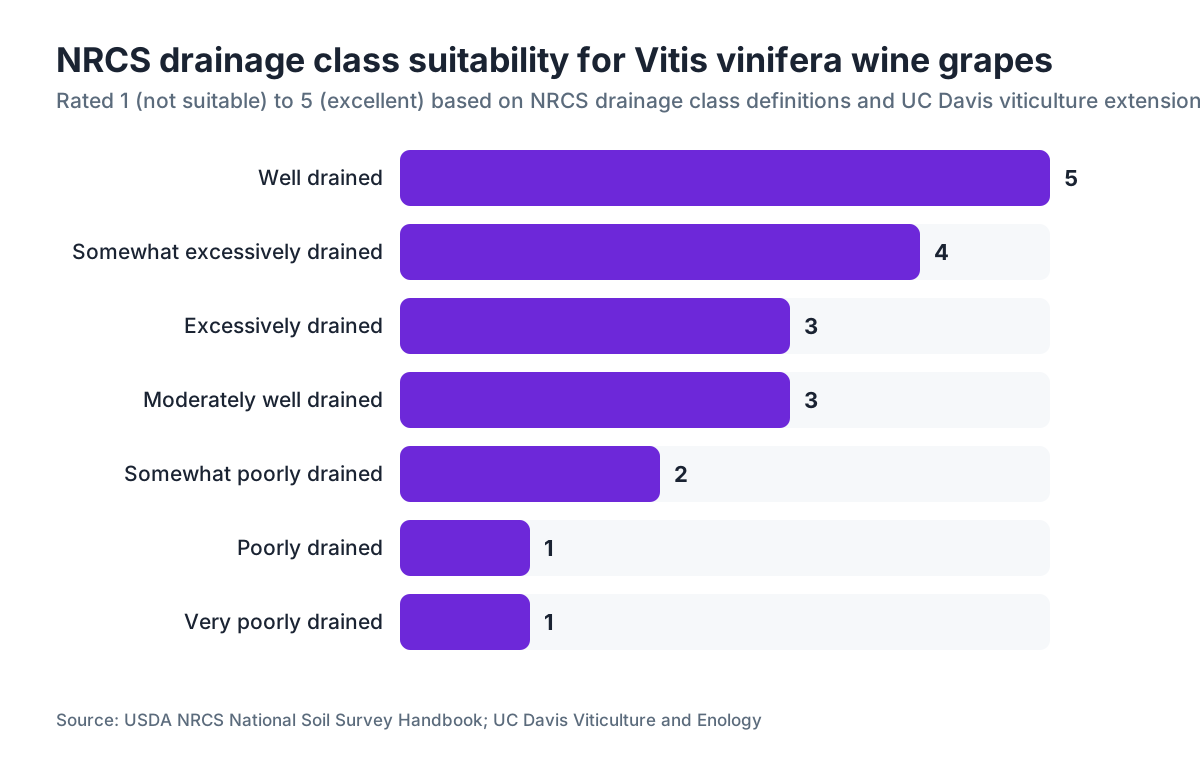
Drainage class kills bad sites fastest. Grapevines shrug off drought far better than waterlogging. NRCS drainage classes run from "Excessively drained" down to "Very poorly drained." For wine grapes, aim for "Well drained" or "Moderately well drained." "Somewhat poorly drained" can work if you'll install subsurface tile, but that capital cost is real and the drainage design needs an engineer. "Poorly drained" is basically a no-go for Vitis vinifera short of massive intervention.
Depth to restrictive layer is the depth where a root hits something it can't get through: hardpan, fragipan, lithic contact, or a perched water table. Want at least 40 inches for vinifera. UC Davis viticulture extension calls 60 inches or deeper ideal [5]. Shallow layers crowd roots, sharpen drought sensitivity, and box in your rootstock choices.
Available water capacity (AWC) gets misread constantly. For table grapes, high AWC is good. For wine grapes, moderate to low AWC (roughly 0.10 to 0.15 in/in across the root zone) creates the mild water stress that tightens clusters and concentrates flavor. Growers in the Paso Robles wineries area go looking for low-AWC calcareous sites for exactly that reason.
Soil pH drives nutrient availability more than it poisons the vine directly. The sweet spot for vinifera is 5.5 to 6.5, though vines grow anywhere from pH 4.5 to 8.5 with the right management [2]. Step outside that 5.5 to 6.5 window and you're into lime applications (for low pH) or sulfur programs (for high pH), both of which belong in your long-run operating cost estimate.
CEC tells you how much nutrient-holding capacity the soil has. Low CEC (below 10 meq/100g) means more frequent, smaller fertilizer applications. High CEC (above 25) on fine-textured soils often runs alongside drainage problems.
Organic matter in ag topsoils rarely tops 3 to 5 percent. For vineyards, 1.5 to 3 percent is a fair target. Very high organic matter can flag poorly drained, anaerobic ground. Very low (below 0.5 percent) points to weak biological activity, and you'll spend years building it back.
What soil drainage classes and depth thresholds should you document?
Here's the table you want in any site-selection report. These thresholds come from NRCS drainage class definitions [4] and UC Davis viticulture extension guidelines [5].
| NRCS Drainage Class | Definition | Vinifera Suitability |
|---|---|---|
| Excessively drained | Water removed very rapidly | Fair (drought risk, may need irrigation) |
| Somewhat excessively drained | Water removed rapidly | Good |
| Well drained | Water removed readily | Excellent |
| Moderately well drained | Water removed somewhat slowly | Good (monitor wet seasons) |
| Somewhat poorly drained | Water removed slowly | Marginal (tile drain may help) |
| Poorly drained | Water removed very slowly | Not suitable for vinifera |
| Very poorly drained | Water remains at or near surface | Not suitable |
| Depth to Restrictive Layer | Rating |
|---|---|
| 60+ inches | Ideal |
| 40-60 inches | Acceptable |
| 24-40 inches | Marginal; rootstock selection critical |
| Below 24 inches | Not suitable without major amendment |
Document both the representative value and the range NRCS reports for each map unit. When a parcel holds multiple map units, weight the averages by percent coverage. That weighted average is what goes in your executive summary table.
How do you document soil survey findings for a permit or loan application?
Lenders and county planning departments don't want raw NRCS tables. They want an interpreted, signed summary that says whether the site suits the proposed use, why, and what work comes next.
A standard vineyard site-selection document should carry these sections:
- Parcel identification. Legal description, APN, GPS coordinates of the AOI boundary.
- Survey source and date pulled. "USDA-NRCS Web Soil Survey, Official Soil Series Description accessed [date]." The data is versioned, so log the date you pulled it.
- Map unit summary table. All map units, percent coverage, key properties (drainage class, depth to restriction, pH, AWC, flood frequency). One row per unit.
- Weighted average analysis. Weighted by acreage for the key variables.
- Suitability narrative. One or two paragraphs per major constraint. Be honest about what the data shows.
- Proposed mitigation. If a constraint exists (low pH, shallow hardpan), describe the planned fix and estimated cost.
- Supplemental data planned. Soil sampling grid, pedon pits, or infiltration tests that will confirm or refine the NRCS findings.
For an ag loan through USDA Farm Service Agency or a commercial ag lender, they want to see you screened for farmland classification too, because that touches crop insurance eligibility and USDA program access [3].
For a TTB American Viticultural Area petition, soil data is one of the required distinguishing features. TTB regulations at 27 CFR Part 9 require petitioners to describe the area's distinguishing features, and soil series, texture, and drainage characteristics are among the most commonly cited [6]. There you're doing more than proving suitability. You're making a geographic argument, so the map unit names and series descriptions have to be correct and complete.
How does soil survey data connect to an AVA petition?
AVA petitions go to the Alcohol and Tobacco Tax and Trade Bureau under 27 CFR Part 9 [6]. The rule asks a petitioner to describe "the evidence that the proposed area has distinguishing features" and explain why those features set it apart from the surrounding area. Soil is one of four primary categories TTB weighs, alongside climate, topography, and geological history.
For soil, your petition needs to do three things. Name the dominant soil series and map units inside the proposed AVA boundary. Contrast those with the dominant series outside it. Explain why the differences matter for viticulture, which means translating drainage class, parent material, and texture into vine behavior and wine character.
This is where a clean Web Soil Survey extraction for both the interior and the exterior comparison areas earns its keep. Pull the same set of variables for both zones and build a simple comparison table. If the interior runs well-drained, shallow, rocky soils with Ksat above 10 micrometers/sec, and the exterior runs fine-textured soils with restrictive layers at 20 inches, that's a real distinction. Say it plainly.
Washington State University's viticulture extension has published on how Pacific Northwest AVA petitions used soil differentiation to draw boundaries, and it's worth reading even if you're planting in California or New York [7]. The logic is the same everywhere: NRCS map units, documented contrast, and viticultural relevance.
An AVA petition can run two to five years from filing to approval. Keeping your soil data, comments, and revisions in one system through all of it matters. VitiScribe is built for this kind of long-running compliance work, where you attach NRCS exports to a parcel record and track version history.
What additional soil tests should you run to confirm Web Soil Survey data?
Web Soil Survey gives you the map. You still have to walk the ground. Before you commit capital to a planting, run at least these field investigations:
Backhoe pits. Dig one pit per distinct map unit, down to 60 inches or the restrictive layer, whichever comes first. Record horizon depths, textures by feel, structure, color (Munsell chips), mottling, and root presence. Mottling in a horizon is a field sign of periodic anaerobic conditions even when NRCS calls the unit "well drained."
Grid soil sampling. A 2-acre or finer grid is standard for wine grapes. Sample each grid point at 0-12 inches and 12-24 inches. Send to an agricultural lab for pH, CEC, organic matter, P, K, Ca, Mg, B, and Zn at minimum. Add a nematode bioassay if you're replanting an old vineyard site. Lab costs run roughly $35 to $80 per sample depending on the panel [2].
Percolation or infiltration tests. A simple double-ring infiltrometer gives you a field-measured Ksat you can check against the NRCS modeled value. A gap of one order of magnitude or more is a flag that the map unit assignment may be wrong for that spot.
Electrical resistivity or EM38 survey. On large parcels (10+ acres), a geophysical survey maps soil variability faster than manual sampling. UC Davis and WSU have both published protocols for EM surveys in vineyards [5][7]. The output is a variability map you lay over the Web Soil Survey polygons to see where the boundaries hold and where they don't.
All of this data goes into your site documentation as supplemental exhibits. It doesn't replace the NRCS data. It calibrates it to your parcel.
How do slope and aspect interact with soil survey data in site selection?
Web Soil Survey reports slope as a range within each map unit, not as a site-specific measurement. A map unit listed at 2 to 8 percent might hold a flat north-facing bench and a steep south-facing convex slope inside the same polygon. That gap matters a lot for wine grapes.
Aspect, the compass direction a slope faces, controls heat accumulation, frost risk, and soil moisture. South-facing slopes in the northern hemisphere catch more solar radiation than flat or north-facing ground, which means warmer soil, faster organic matter mineralization, and usually lower AWC because evapotranspiration runs higher. In cool-climate regions (Willamette Valley, Finger Lakes, Hudson Valley), a south-facing slope on otherwise marginal soil can grow excellent fruit. In warm regions (central San Joaquin Valley, inland Paso Robles), that same south-facing slope can push heat past the stress threshold for premium vinifera.
For your documentation, start with the Web Soil Survey slope range, then pull a 1-meter or 10-meter Digital Elevation Model (USGS National Map, free at nationalmap.gov) to derive real slope and aspect rasters for your parcel [8]. A GIS technician can overlay those with your NRCS map units and grid sampling points to build a composite suitability map. That map, with its sources documented, reads far more convincing in a permit application than either dataset alone.
Frost pockets are another slope interaction. Cold air drains downslope and pools in low spots, valley bottoms, and areas dammed by tree lines or buildings. Web Soil Survey doesn't model frost, but NRCS drainage class works as a partial proxy: poorly drained soils in low positions are often frost pockets too. Document this separately using elevation data and local frost records from the nearest NOAA weather station [9].
What do lenders and county planners actually want to see in a soil report?
Lenders want two things: evidence the land can carry the proposed enterprise, and a paper trail that protects them if it can't. So your soil documentation has to be signed (by you or a consultant), dated, and tied to a specific parcel description. Bare printouts from Web Soil Survey without interpretation get you nowhere.
For an ag operating loan or a USDA Farm Service Agency loan, the lender or agency usually orders its own appraisal, which includes a soils review. Your documentation doesn't replace that. It informs it and speeds it up. If your report shows you understand the drainage constraints and have a tile drain design ready, that's a risk-reduction argument the underwriter can use.
County planners in ag zones mostly look for two things on the soil side. Is this farmland classification protected land, and does the proposed use comply with agricultural preservation rules? And are there hazards: flooding, erosion, or landslide risk? NRCS hazard interpretations (in the Suitability and Limitations tab) cover all of these, and they should be pulled and included.
One item people skip: the Erosion Hazard rating tied to the T-factor (soil loss tolerance in tons per acre per year). NRCS reports it per map unit. If your site carries a T-factor of 1 (highly erodible) and your slope tops 3 percent, county grading permits may demand an erosion control plan before any land prep [3]. Flagging this yourself, with your cover crop and trellising plan attached, beats getting caught by it mid-review.
For environmental review under CEQA (California) or SEPA (Washington), soil survey data feeds the analysis of agriculture and soils impacts. Clean documentation ready at project start shortens the review, sometimes by a lot.
How do you handle sites with multiple soil map units covering different blocks?
Multiple map units in one vineyard are the rule, not the exception. A 20-acre site might hold four or five distinct NRCS polygons, each with its own drainage, texture, and depth. The documentation trick is to treat each unit honestly instead of blending everything into a single number that describes nothing.
The right move is to map your proposed planting blocks against the NRCS polygons and treat each combination as a management zone. This pays off beyond paperwork: it lets you match rootstock to soil depth, set irrigation zones by AWC, and plan fertilizer by CEC and organic matter.
In your site-selection report, include a layer map showing both the NRCS polygon boundaries and your proposed row orientation and block layout. Where a block straddles two map units, note which one dominates by area and flag the boundary zone for extra sampling. A reviewer, lender or planner, can see the complexity at a glance and see that you handled it.
For record-keeping through multi-year establishment, log which map unit each sampling point falls in. Then in year three, when tissue samples show nitrogen deficiency in one block but not another, you can trace it to the CEC difference your Web Soil Survey pull predicted. That link, from pre-plant survey through establishment through production, is what separates a real vineyard record system from a pile of loose files.
Are there regulatory or worker protection considerations tied to soil type?
Yes, and this part of site documentation gets overlooked. Two main connections:
Pesticide label restrictions and soil texture. Plenty of fungicide and herbicide labels carry soil-specific restrictions. Pre-emergent herbicides are the clear case: labels for products like simazine or oryzalin set minimum organic matter percentages and restrict use on coarse-textured (sandy) soils because of leaching risk to groundwater. If your NRCS data shows coarse, low-organic-matter soils, that trims your herbicide options from day one, and it belongs in your spray program planning.
EPA Worker Protection Standard and field re-entry. The EPA's Worker Protection Standard (40 CFR Part 170) sets re-entry intervals (REIs) and field worker protections during and after pesticide applications [10]. WPS isn't tied to soil type directly, but your spray program is, and your spray program depends on which diseases and pests your soil and microclimate favor. Heavy clay that stays wet through spring raises Botrytis and Phytophthora pressure, which drives a heavier fungicide program. Document that connection in your site analysis so your spray records rest on agronomic reasoning, more than the calendar.
Nitrate leaching and groundwater. In some counties and states, vineyard operations near drinking water sources have to show their fertilization program won't cause nitrate leaching. NRCS's Nitrate Leaching Potential interpretation (in the Soil Data Explorer) is the screening tool. Sites with sandy, low-CEC, high-Ksat soils inside drinking water protection zones may need extra review or a nutrient management plan. California's Irrigated Lands Regulatory Program is one place this bites [11].
Document all of these in your pre-plant site report, even where they don't trigger regulatory action. It shows you did the screening.
What resources from UC Davis, Cornell, and WSU should you use alongside Web Soil Survey?
These three land-grant programs publish the most useful viticulture extension material in the US, and each has soil-specific content worth a bookmark.
UC Davis Viticulture and Enology has published on site selection factors, rootstock-soil interactions, and how soil surveys fit into vineyard establishment. Their Soil Resource Inventory method, built for coastal California wine regions, makes a solid template for your own documentation structure [5].
Cornell Cooperative Extension covers the cool-climate, heavy-textured soils of New York. Their viticulture team has practical guides on reading drainage class in Finger Lakes and Hudson Valley geology, where glacial till switches soil type over short distances that Web Soil Survey polygons don't always catch at fine scale [2].
WSU Extension covers Pacific Northwest conditions: volcanic parent materials, silty loess-derived soils, and the tricky rapidly draining Columbia Basin soils where NRCS AWC estimates can overstate actual plant-available water because irrigation timing runs so aggressive [7].
All three also publish rootstock guides that cross-reference soil properties, which is the exact link your documentation needs to make: here is the soil, here is the rootstock that fits it, here is the reasoning. That chain of inference turns a data dump into a credible site evaluation.
USDA-NRCS itself publishes the Web Soil Survey User Guide and technical notes on how map unit descriptions get built, useful background for understanding the confidence around the data you're reporting [1].
Frequently asked questions
Is Web Soil Survey data accurate enough to make a planting decision?
It's accurate enough to screen sites and eliminate obvious problems, but not accurate enough to finalize a planting decision on its own. NRCS map units represent the modal (most common) soil condition in a polygon, not every point within it. Backhoe pits and grid soil sampling are needed before you commit to a specific block layout or rootstock choice. Use Web Soil Survey to narrow candidates, then confirm with field work.
What drainage class do I need for Vitis vinifera wine grapes?
Well drained is ideal. Moderately well drained is acceptable with monitoring. Somewhat poorly drained requires subsurface tile drainage before planting, which adds significant cost. Poorly drained and very poorly drained are not suitable for vinifera without transformative site modification that rarely pencils out economically. Document the drainage class of every map unit in your site report.
How do I find the soil survey data for a specific parcel?
Open the Web Soil Survey site, click Start WSS, and search by address or move the map to your parcel. Draw an area of interest polygon. The tool automatically identifies the NRCS survey area covering that location and returns all map units within your AOI with tabular soil properties. Download the Soil Report PDF and the tabular data export for your records.
Does the NRCS soil survey cover every county in the US?
Web Soil Survey covers approximately 95 percent of the US land area with Official Soil Survey data. A small share sits in "Soil Survey in Progress" or "Not Surveyed" status, mostly in remote western areas. If your parcel falls in a gap, you'll lean on state geology maps and field investigation without NRCS map unit data as a starting point.
What is available water capacity (AWC) and what's ideal for wine grapes?
AWC is the amount of water a soil holds between field capacity and permanent wilting point, expressed in inches of water per inch of soil. For wine grapes, moderate to low AWC (roughly 0.10 to 0.15 in/in) is often desirable because it creates mild water stress that improves fruit quality. High AWC soils tend to grow vigorous vines with large clusters and dilute flavor, which requires aggressive canopy management to compensate.
Do I need a professional consultant to interpret Web Soil Survey for a permit application?
Not always. Many vineyard managers interpret Web Soil Survey themselves for initial screening and lender documentation. For a formal county permit, an environmental review, or a TTB AVA petition, having a licensed professional soil scientist or Certified Crop Adviser review and sign your soil documentation adds credibility and reduces risk of challenge. A site review typically runs a few hundred to a few thousand dollars depending on parcel size and complexity.
What soil pH range is acceptable for wine grapes?
Grapevines grow in soils from pH 4.5 to 8.5, but the practical target for nutrient availability and vine health is pH 5.5 to 6.5. Below 5.5, aluminum and manganese toxicity become concerns and phosphorus availability drops. Above 7.5, iron and zinc deficiency are common. Document the pH for each horizon and each map unit in your site report, and note any planned amendment program.
How does the NRCS farmland classification affect vineyard development permits?
Prime Farmland and Farmland of Statewide Importance designations are listed in NRCS Web Soil Survey data. Some counties and states require additional review or mitigation for converting these lands to new uses, including vineyards. California's Williamson Act and Washington's Agricultural Land of Long-Term Commercial Significance designations both use farmland classification as part of their legal framework. Check local zoning rules before assuming a high classification is a benefit or a barrier.
What is the T-factor in NRCS soil data and why does it matter for vineyards?
The T-factor is the maximum annual soil loss, in tons per acre per year, that a soil can sustain without long-term productivity decline. NRCS assigns values from 1 (most sensitive) to 5 (more tolerant). For vineyards on slopes with T-factors of 1 or 2, county grading permits often require an erosion control plan. Document the T-factor for each map unit in your site report and note your proposed cover crop strategy.
Can I use Web Soil Survey data in a TTB AVA petition to distinguish soils inside and outside the proposed boundary?
Yes, and it's one of the most common approaches. Pull the dominant map units and series descriptions for both the interior and a buffer area outside your proposed boundary. Tabulate the key differentiating properties: drainage class, parent material, texture, depth to restriction. Then write a clear paragraph explaining why those soil differences are agronomically meaningful. TTB reviewers respond well to documented contrast rather than qualitative claims.
What supplemental soil tests should I run beyond what Web Soil Survey provides?
Run backhoe pits to 60 inches in each map unit, grid soil sampling on a 2-acre or finer grid at two depths (0-12 and 12-24 inches), and a percolation or infiltration test to verify NRCS Ksat estimates. On parcels over 10 acres, an EM38 survey gives rapid variability mapping that helps you see where NRCS polygon boundaries hold and where they don't. Lab sampling costs roughly $35 to $80 per sample depending on the analytical panel.
How do I document soil survey findings if a parcel has multiple different soil types?
Map your proposed planting blocks against the NRCS polygons. Treat each block-by-polygon combination as a separate management zone. In your site report, include a layer map showing both, and present a separate data row for each map unit. For blocks straddling two units, note which dominates by area and flag the boundary zone for extra sampling. This structure lets lenders and planners see the variability without being overwhelmed by it.
Are there pesticide label restrictions based on soil type that I should know before planting?
Yes. Pre-emergent herbicide labels commonly restrict use on coarse-textured, low-organic-matter soils because of groundwater leaching risk. If Web Soil Survey shows sandy or gravelly soils with organic matter below 1 percent, review your planned herbicide options against label language before committing to those products. Document this review in your pre-plant site report as part of your integrated pest management planning.
How often is Web Soil Survey data updated, and does my report need a date stamp?
NRCS updates individual survey areas on an ongoing basis as new pedon data, series revisions, or boundary corrections come in. The update frequency varies by county. Always record the date you accessed and downloaded the data in your site-selection report. This matters for AVA petitions and environmental reviews where reviewers may want to confirm the data version. There is no automatic notification if the data changes after your pull.
Sources
- Cornell College of Agriculture and Life Sciences, Viticulture and Enology: NRCS survey data should be used to screen sites, with field confirmation via soil cores and backhoe pits before planting; lab sampling costs roughly $35 to $80 per sample
- UC Davis Viticulture and Enology: UC Davis recommends 60 inches or deeper to restrictive layer as ideal for vinifera; Soil Resource Inventory methodology developed for coastal California wine regions
- TTB, 27 CFR Part 9, American Viticultural Areas: TTB regulations require AVA petitioners to describe evidence that the proposed area has distinguishing features including soil series, texture, and drainage characteristics
- Washington State University Extension: WSU extension publishes guidance on Pacific Northwest AVA petitions using soil differentiation and protocols for EM38 surveys in vineyards
- USGS, The National Map: 1-meter and 10-meter Digital Elevation Models available free for deriving slope and aspect rasters for vineyard site analysis
- NOAA National Centers for Environmental Information: Local frost records from NOAA weather stations used to document frost pocket risk in vineyard site-selection reports
- EPA, Agricultural Worker Protection Standard, 40 CFR Part 170: EPA Worker Protection Standard governs re-entry intervals and field worker protections during and after pesticide applications in agricultural settings including vineyards
- California State Water Resources Control Board: California's Irrigated Lands Regulatory Program requires vineyard operations near drinking water sources to demonstrate that fertilization programs will not cause nitrate leaching
Last updated 2026-07-11