How to document erosion control practices for water board compliance

TL;DR
- Water board compliance for vineyard erosion control means keeping dated, site-specific records of every practice you install or maintain: weed strips, cover crops, sediment basins, road work, and storm inspections.
- California's Irrigated Lands Regulatory Program and its state cousins require you to document what, where, when, and who.
- Vague or missing records are the number one reason growers get a notice of violation.
What do water boards actually require vineyard operators to document?
They want proof you planned, installed, and inspected every erosion and sediment control practice on the property, each one tied to a specific place and date. That's the whole game.
In California, the North Coast Regional Water Quality Control Board's vineyard program runs under the state's Irrigated Lands Regulatory Program (ILRP). Growers with more than one acre of irrigated vineyard file an annual self-certification and keep supporting records on-site for at least three years [1]. Those records have to show which Best Management Practices (BMPs) are in place, where they sit, and that you're maintaining them.
Other states run parallel programs. Washington's Department of Ecology administers agricultural water quality work under Chapter 90.64 RCW, and Oregon's Department of Agriculture oversees Agricultural Water Quality Management Area plans county by county [2][11]. The language differs. The documentation expectation does not: a written BMP plan, dated field inspection records, and evidence you fixed things when they failed.
Four categories of records show up in almost every audit request. The current site map showing practice locations. Installation records with dates. Storm-season inspection logs. Corrective action notes for anything that got damaged or fell short. Hand an inspector a folder with those four things organized cleanly and you're in good shape.
What is a farm water quality plan and do you need one?
A Farm Water Quality Plan (FWQP) is a written document describing your operation, the erosion and runoff risk on each block, and the BMPs you use or plan to use against those risks. It's your compliance baseline. Most irrigated vineyards need one.
In California, irrigated agricultural operations including vineyards fall under a General Order or conditional waiver run through their regional water board. Growers in the ILRP either join a Third-Party Group (a grower coalition that files on your behalf) or file individually [3]. Either path assumes the underlying farm plan already exists.
UC Cooperative Extension has published farm water quality planning guidance through its work with the California Department of Food and Agriculture. A good plan includes a property map, a list of water features and drainage paths, a current BMP inventory, and a schedule for any improvements [4]. The plan does not need to be long. A two-page narrative with a hand-drawn map and a BMP checklist covers the minimum for most small vineyards.
Washington State University Extension publishes similar material for growers in the Columbia River basin, where Ecology's agricultural program sets guidance under the Yakima Agricultural Water Quality Management Area Plan [2][8].
Never written one? Start with your county's Resource Conservation District (RCD). They give free or low-cost technical help and usually have templates matched to your regional water board's expectations.
Which erosion control practices require the most documentation?
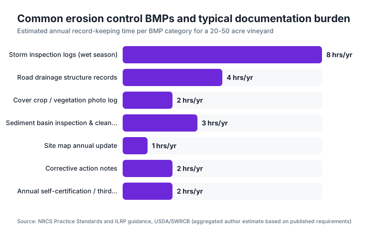
Not every practice carries the same paperwork weight. The ones water boards scrutinize hardest are the ones that dump sediment straight into a water body when they fail.
Vineyard roads top the list in nearly every regional erosion study. Research published in UC's California Agriculture journal found that unpaved vineyard roads deliver a disproportionate share of total sediment loads in North Coast watersheds, which puts road drainage and surface stabilization at the front of your documentation queue [4]. For every culvert, water bar, or armored dip, record the location (GPS coordinates or a block reference), the install date, the structure type, and the crew or contractor who built it.
Cover crops and in-row vegetation need records too, but simpler ones. A dated photo log does the job: one photo per block per year showing the inter-row condition in late fall before the rains, one in spring. Add a note on species planted or germination date.
Sediment basins and detention ponds demand the most formal records. Keep the original design spec (a hand sketch is fine), the as-built dimensions, the excavation date, and annual or post-storm inspection notes showing whether it's filling with sediment and whether the outlet structure is intact.
Wetted furrow irrigation and tailwater return systems sit under the ILRP as well. Document your irrigation scheduling and where field tailwater goes, especially if it could reach a drainage channel.
Anything installed with NRCS cost-share money under EQIP (Environmental Quality Incentives Program) already has a practice standard and payment file behind it. Those records cover a lot of what water boards want, so keep copies of your EQIP contract and practice installation certificates [5].
How do you set up a storm inspection log that will hold up to scrutiny?
The storm inspection log is the record that separates growers who pass an audit from growers who get a follow-up notice. It's also the first thing people let slide.
The common standard, reflected in MS4 permit guidance and agricultural waiver requirements, is to inspect critical erosion areas before the first significant storm of the season, within 24 hours after any storm over 0.5 inches in 24 hours, and at least monthly through the wet season [1][6]. Some regional boards set different thresholds, so check yours.
Your log needs the date and time, who inspected, current weather and recent rainfall (from a local NOAA gauge or your own rain gauge), the specific locations checked, what you saw (condition of each BMP, any rill formation, scour, or turbid runoff), and any corrective action you took or scheduled.
Here's a format that works:
| Date | Inspector | Rainfall (in, prior 24h) | Location inspected | Condition observed | Action taken | Follow-up needed? |
|---|---|---|---|---|---|---|
| 11/15/2024 | J. Reyes | 0.8" | Block 4 road, culvert #3 | Outlet clear, no scour | None | No |
| 12/02/2024 | J. Reyes | 1.3" | All road culverts, sediment basin A | Basin 60% full | Scheduled cleanout for 12/10 | Yes, record cleanout date |
Keep the log in a binder on the property or in a cloud folder you can open on a phone mid-inspection. A one-paragraph note in a phone app beats nothing. A structured log beats the note.
Don't round rainfall to "about an inch." Pull the actual figure from the closest NOAA cooperative observer station and write down the real number [12]. Inspectors can tell when numbers look invented.
What does a complete site map need to show?
Your site map is the spatial anchor for everything else. Without it, individual records float free and an inspector can't verify you've covered the whole property.
At minimum the map shows property boundaries, all vineyard blocks with block IDs, drainage channels and any seasonal or perennial watercourses, every BMP by type (water bars, culverts, sediment basins, cover crop blocks, filter strips), steep slopes above roughly 15 percent grade, and any wells or water supply infrastructure.
You don't need a professional survey. A georeferenced aerial screenshot from Google Earth with hand-drawn overlays, printed at 11x17, works for most small operations. NRCS field offices can hand you a Web Soil Survey map that already shows slope classes and soil types, which pairs cleanly with your BMP overlay [5].
Update the map whenever you add or remove a practice. Date every version and write the revision date in the corner of the print. If an inspector holds your 2020 map while your 2024 notes reference a culvert that isn't drawn on it, you've handed them a credibility problem you didn't need.
Growers on the North Coast near Class I or Class II watercourses should mark required stream setbacks and riparian buffer zones on the map. California's Forest Practice Rules define buffer widths for timber harvest, and water board staff often reference similar standards for vineyard work on steep, forested ground [1].
How long do you need to keep erosion control records?
Three years is the statutory minimum under California's ILRP for most irrigated agricultural operations [1]. EQIP has its own rule: NRCS generally requires records for the life of the contract plus three years [5].
Keeping five years of records costs you almost nothing beyond storage, and it protects you against delayed enforcement or watershed-level audits that look at historical trends. Regional boards can issue a notice of violation based on conditions seen during a site visit that point back to past growing seasons.
Store records in two places. A physical binder on the property meets the "available for inspection" requirement under most state rules. A digital backup, a shared drive, a farm record-keeping app, or a synced folder of phone photos, protects you when the binder is lost to a flood or a barn fire.
Some operators use purpose-built tools like VitiScribe to hold field notes, spray records, and compliance docs in one place with automatic date-stamping. That makes pulling a three-year audit package a matter of minutes instead of a scavenger hunt through a stack of paper. It pays off most the week a water board inspector calls with 48 hours notice.
What are the most common documentation gaps that trigger enforcement?
Read enough SWRCB annual compliance reporting and talk through what extension advisors flag, and the same gaps surface over and over. Here are the five that catch growers.
Missing storm inspection records is the big one. Growers install good BMPs and then never write down that they inspect and maintain them. A sediment basin built in 2018 and never inspected on paper looks identical, to an auditor, to a basin that was never built.
Out-of-date site maps come second. A map from planting year that doesn't show a road cut in 2021 or a pond added in 2023 opens a gap between what you claim and what's documented.
Third is self-certification filed without supporting records. Third-Party Groups submit annual reports built on member certifications. Certify that you have cover crops in every block but keep no planting records or photo log, and a targeted audit will expose you.
Fourth is vague corrective action notes. "Fixed culvert" is not a record. "Replaced cracked inlet ring on culvert #7, Block 2 road, 11/22/2024, R. Torres" is a record.
Fifth is no paper on contractor work. If a road contractor regraded your access road, get an invoice or written statement with the date, the work done, and the location. That's your installation record for any drainage structures they built or repaired.
How does the EPA's general permit framework affect vineyard erosion documentation?
Most vineyards sit outside the federal NPDES Construction General Permit unless they're actively grading or disturbing more than one acre. The EPA framework still matters, because state water boards draw their authority from the federal Clean Water Act, and the documentation standards in the CGP have shaped what state programs expect [6].
The CGP requires operators to write a Stormwater Pollution Prevention Plan (SWPPP) with a site map, a BMP description, and an inspection log. Agricultural operations get a statutory exemption from NPDES stormwater permitting under section 402(l) of the Clean Water Act, but that exemption stops at point source discharges and concentrated animal feeding operations [6]. Vineyard drainage that channels into a pipe or a concrete ditch discharging to a water body can be treated as a point source.
This is a genuinely gray area, and nobody should pretend otherwise. The line between exempt nonpoint runoff and a channelized discharge that might be regulated turns on site-specific facts [6]. If your vineyard has engineered drainage that concentrates flow and discharges to a named watercourse, document the discharge point, the receiving water body, and the BMPs controlling runoff quality there. Better to hold that record and never need it than to face a question about an outlet you can't explain.
Cornell Cooperative Extension publishes practical guidance on riparian buffer design and agricultural stormwater management for the Northeast that carries over to erosion documentation logic in any state [7].
How do third-party grower groups help with compliance documentation?
Third-party groups are coalitions of agricultural operators that file collective water quality reports with the regional board for their members. In California, examples include the Lodi Winegrape Commission's grower outreach program and various county Farm Bureau coalitions [3].
Joining one does not erase your individual obligations. You still keep your own farm water quality plan, BMP records, and inspection logs. What the group does is aggregate data, provide technical help, submit the formal annual report to the board, and give you someone to call when a question comes up.
The group's report references your individual certification. Say your certification claims riparian buffers but your on-farm records don't document them, and you've built in an inconsistency that surfaces during a targeted inspection. Treat the group's filing as a summary your own records have to back up.
Groups also hand out template forms, run workshops, and sometimes do on-farm assessments. These are worth your time. The template inspection log a group provides is usually calibrated to exactly what your regional board wants, which saves you from guessing. Use it.
What records do you need if you're also doing earthwork or new planting?
Grading, road building, and new vineyard development trigger a higher documentation standard, because sediment loss during land disturbance dwarfs what happens during normal farming.
In California, projects disturbing more than one acre in a water quality-sensitive area may need a county Grading Permit and, in some North Coast counties, project-level review under the California Environmental Quality Act [1]. The permit application builds its own paper trail: the grading plan, the erosion control plan (sometimes called a Winter Operations Plan), the haul route, and the revegetation plan are all records you keep permanently.
For every phase of grading, document the area disturbed (in acres), the start and end dates, the temporary erosion controls installed during active work (silt fences, fiber rolls, hydromulch), and the date final stabilization was reached. "Final stabilization" generally means 70 percent vegetative cover on all disturbed areas, the threshold used in the Construction General Permit and echoed by most state programs [6].
Planting a new block on a slope above 15 percent? Photograph the finished grade, the drain installation, and the first cover crop germination. Those three photos, taken the same season you plant, beat a written description written five years later.
WSU Extension recommends recording soil amendments, cover crop species, and row orientation relative to slope aspect at establishment, because those choices shape erosion risk for the life of the vineyard [8].
What's the simplest documentation system that actually works?
The best system is the one you'll keep up through a wet November while you're also chasing harvest cleanup and a broken sprayer. Complexity kills compliance.
Here's the minimum viable setup for a vineyard under 50 acres.
One binder, five tabs: (1) Farm Water Quality Plan and current site map, (2) BMP installation records, (3) storm inspection logs, (4) corrective action records, (5) regulatory correspondence and annual certification copies.
One folder on your phone, synced to a shared drive, holding dated photos organized by block and season. A file named "Block3_NW_road_11142024.jpg" tells you everything at a glance.
One rain gauge with a log sheet on the door of whatever building you pass every morning. Read it, write it down, reset it after every real event.
Managing larger acreage or multiple properties? VitiScribe structures field observations, storm event triggers, and BMP records in a format you can export straight into a water board audit package. Even a shared Google Sheet and a Dropbox folder of photos beats a drawer of sticky notes.
Update the site map every January. File the corrected version, label the old one "superseded." That yearly map refresh takes about 20 minutes and closes the single most common audit gap.
Frequently asked questions
Does a small vineyard under 10 acres still need erosion control documentation?
In California, the ILRP applies to irrigated agricultural operations of one acre or more, so yes, a small irrigated vineyard still needs a farm water quality plan and basic BMP records. The standard is simpler for small operations, but the obligation stands. Check your regional water board's threshold, because some waivers apply differently by watershed or risk tier.
What triggers a water board inspection of a vineyard?
Most inspections are complaint-driven, usually a downstream neighbor or environmental group reporting visible turbid runoff or erosion into a watercourse. Targeted inspections follow watershed-level audits by regional board staff, especially in high-priority watersheds like the Russian River or Navarro. A self-certification that conflicts with satellite imagery can draw scrutiny. Unpermitted grading is a common trigger in North Coast counties.
Can photos substitute for written inspection records?
Photos are strong evidence but not enough alone. A photo shows condition at one moment; a written log shows you evaluated it against a standard. The pair is far more defensible. Date-stamp photos through your camera app or a GPS photo logger, and pair each session with at least a one-line note: who inspected, what they checked, and whether any follow-up is needed.
What's the penalty for missing or incomplete erosion control records in California?
The SWRCB can issue a Notice of Violation, then a Cleanup and Abatement Order or a Civil Liability Order. Administrative civil liability can reach $10,000 per day of violation for discharges that affect water quality under California Water Code section 13350 [9]. Most first-time documentation failures draw a compliance schedule rather than immediate fines, but repeated or egregious gaps move quickly to enforcement.
Do cover crops count as a BMP for water board purposes?
Yes. Cover crops in vine rows and on headlands are recognized BMPs under California's ILRP, NRCS Practice Standard 340 (Cover Crop), and most regional agricultural water quality programs [10]. Document the species seeded or the seed mix label, the seeding date, and a post-germination photo. For a permanent cover crop, note the species and establishment date. That record supports your annual self-certification.
How do NRCS EQIP records interact with water board documentation?
EQIP practice installation certificates and as-built documentation from your local NRCS service center meet or exceed what most water boards want as installation records. Keep copies in your farm binder. An EQIP-funded sediment basin with an NRCS 378 practice standard certificate is about the most bulletproof installation record you can hold. The ongoing inspection duty is still yours regardless of EQIP funding [5].
What should a corrective action record include?
It needs the date the problem was found, who found it, a description of what failed (not 'culvert issue' but 'outlet pipe at Block 2 road crossing blocked by debris, causing overflow to downslope rip-rap'), the corrective action taken, the completion date, and who did the work. One paragraph does it. Vague notes create gaps that look worse than an honest account of a failure and its fix.
How does vineyard erosion documentation differ from construction site SWPPP requirements?
Construction sites under the EPA's Construction General Permit need a formal SWPPP before work starts, with specific BMP design specs and daily inspection logs during active grading. Operating vineyards are generally exempt from the CGP under the Clean Water Act's agricultural stormwater exemption, but the documentation logic mirrors it: site map, BMP inventory, inspection log, corrective action record. The difference is formality and triggering thresholds, not the underlying structure.
What role does a Resource Conservation District play in erosion control compliance?
RCDs provide free or subsidized technical help for writing farm water quality plans, designing erosion control practices, and reading local water board expectations. They are not enforcement agencies. Many RCDs partner with regional water boards to run on-farm assessments that can satisfy some compliance requirements. Connecting with your local RCD before an inspection is one of the best low-cost moves a vineyard operator can make.
Do I need to document erosion controls on leased vineyard land?
Yes. The operator of the irrigated land, more than the landowner, carries compliance responsibility under most state programs. If you lease vineyard blocks, you're the operator for ILRP purposes. Your lease should address who maintains BMP records, but from the water board's view, the party conducting farming operations holds the obligation. Put this in writing with your landlord.
How often should I update my farm water quality plan?
Review it annually at minimum. Update it whenever you add a block, change a drainage structure, modify irrigation, or install or remove a BMP. Most regional boards expect the plan to reflect current conditions, not the year it was written. A plan last touched in 2017 for a vineyard that added 15 acres in 2021 is not compliant. Date every revision in the document header.
Is there a standard form for vineyard erosion control inspection logs?
There's no single statewide form. California's ILRP doesn't mandate a specific format, which gives you flexibility but means you design your own. Third-party groups often supply templates. UC Cooperative Extension's Sonoma and Napa County offices have published sample inspection log formats. Your local RCD may also have templates aligned to your regional board's expectations.
What records do I need for a riparian buffer or filter strip?
Document the location (GPS or block reference and distance from the watercourse), the buffer width, the vegetation type (permanent grass, shrubs, trees, or a mix), the establishment date, and annual observations on cover and condition. If the buffer went in with NRCS funding, the NRCS 393 practice standard documentation covers most of this. Photograph the buffer each fall before the wet season as a simple condition record.
Sources
- California State Water Resources Control Board, Irrigated Lands Regulatory Program: California's ILRP requires irrigated agricultural operators to maintain BMP records and self-certify annually; records must be kept on-site for at least three years
- Washington State Department of Ecology, Agriculture and Water Quality Program: Washington's agricultural water quality program under Chapter 90.64 RCW requires operators to implement and document agricultural best management practices
- California State Water Resources Control Board, ILRP Third-Party Groups: Growers covered by the ILRP may join a Third-Party Group that files collective annual reports; individual farm water quality plans and BMP records are still required of each member
- UC Agriculture and Natural Resources, California Agriculture journal (North Coast vineyard erosion and sediment research): Research in California Agriculture found that unpaved vineyard roads contributed a disproportionate share of total sediment loads in North Coast watershed studies, making road drainage documentation the top priority
- EPA, Stormwater Discharges from Construction Activities (Construction General Permit): The EPA CGP requires a SWPPP with site map, BMP descriptions, and inspection logs; final stabilization threshold is 70 percent vegetative cover; agricultural stormwater is exempt under CWA section 402(l) unless discharged from a point source
- Cornell Cooperative Extension, Environment and Natural Resources (water quality program): Cornell Extension provides guidance on riparian buffer design and stormwater documentation for agricultural operations in the Northeast applicable to erosion control record-keeping logic
- Washington State University Extension: WSU Extension recommends documenting soil amendments, cover crop species, and row orientation relative to slope aspect at vineyard establishment as part of the initial site erosion risk record
- California Water Code Section 13350, Civil Liability for Waste Discharge Violations: Administrative civil liability under California Water Code section 13350 can reach $10,000 per day of violation for discharges that affect water quality
- Oregon Department of Agriculture, Agricultural Water Quality Program: Oregon's Agricultural Water Quality Management Area plans require producers to implement and document BMPs addressing erosion and sediment control; plan requirements vary by county management area
- NOAA National Centers for Environmental Information, Cooperative Observer Network: NOAA's cooperative observer network provides daily precipitation data used to verify rainfall amounts recorded in agricultural storm inspection logs
Last updated 2026-07-11