How to record a sediment basin maintenance inspection in vineyard records
TL;DR
- A sediment basin inspection record needs at minimum: the date, inspector name, basin ID or location, water level and sediment accumulation depth, observed damage or erosion, corrective actions taken, and your signature.
- Many permits require inspection within 24 hours of any rainfall over 0.5 inches.
- Keep these records for at least three years to satisfy most state and federal stormwater permit audits.
Why does recording a sediment basin inspection actually matter?
Most vineyard operators know they need a sediment basin. Far fewer keep the paper trail that proves they're actually managing it. That gap is where compliance problems live.
Under the EPA's Construction General Permit (CGP) and most state-level National Pollutant Discharge Elimination System (NPDES) permits, you have to document that stormwater best management practices (BMPs) are inspected, functional, and maintained. [1] A sediment basin is explicitly listed as a BMP in virtually every state's vineyard or agricultural water quality program. The record isn't optional paperwork. It's the legal evidence that you did the work.
State agencies audit records. If you're in California, the State Water Resources Control Board can request your BMP inspection logs under the Irrigated Lands Regulatory Program. [2] In Washington, WSU viticulture programs have documented that thin BMP paperwork is one of the top reasons vineyard operators get flagged during Department of Ecology reviews. [3]
There's also a plain practical side. A good inspection log tells you when a basin is filling up before it overflows. It tracks whether a repair from two seasons ago actually held. It gives you the numbers to justify equipment time or contractor costs to an owner who wasn't standing in the mud with you. Good records pay back in more than compliance.
What information must a sediment basin inspection record include?
There's no single federal form you're required to use, but the required content is well settled across permit programs. Treat these as non-negotiable fields.
Basin identification. Give every basin a name or number. If you have three sediment basins on a 40-acre block, calling them SB-1, SB-2, SB-3 sounds bureaucratic, but it matters enormously when you're comparing records across years or explaining a repair to a contractor.
Date and time of inspection. The exact date, not a week range. Some permit programs want the time logged too, especially if the inspection was triggered by a storm event.
Inspector name. Full name, not initials. Some operators also log the inspector's role or certification level if your permit requires qualified inspector status.
Weather conditions. What was happening at the time, and what storm event (if any) triggered the inspection. Log the rainfall amount from the nearest gauge or your on-site rain gauge if you have one.
Sediment accumulation depth. Measure it. A staff gauge or measuring rod takes 30 seconds. Most permits and BMP guidance treat a basin as needing cleanout when sediment reaches one-third to one-half of the design storage volume. [4] You can't know where you sit on that scale without a number.
Water surface elevation or freeboard. How much capacity remains above the current water level. This is the field that saves you during wet seasons.
Condition of inlet and outlet structures. Are pipes clear? Is the outlet stable? Is there undercutting, piping, or erosion at the berm?
Berm and embankment condition. Check for animal burrows, erosion rills, settlement, and vegetation loss.
Corrective actions required. List what needs doing, even if you can't do it that day.
Corrective actions completed. Date and description of what you actually fixed, ideally signed off separately when the work is done.
Inspector signature. Required by most permit programs, and good practice regardless.
How often do you need to inspect a sediment basin in a vineyard?
The honest answer is it depends on your permit, and permits vary a lot by state and operation size.
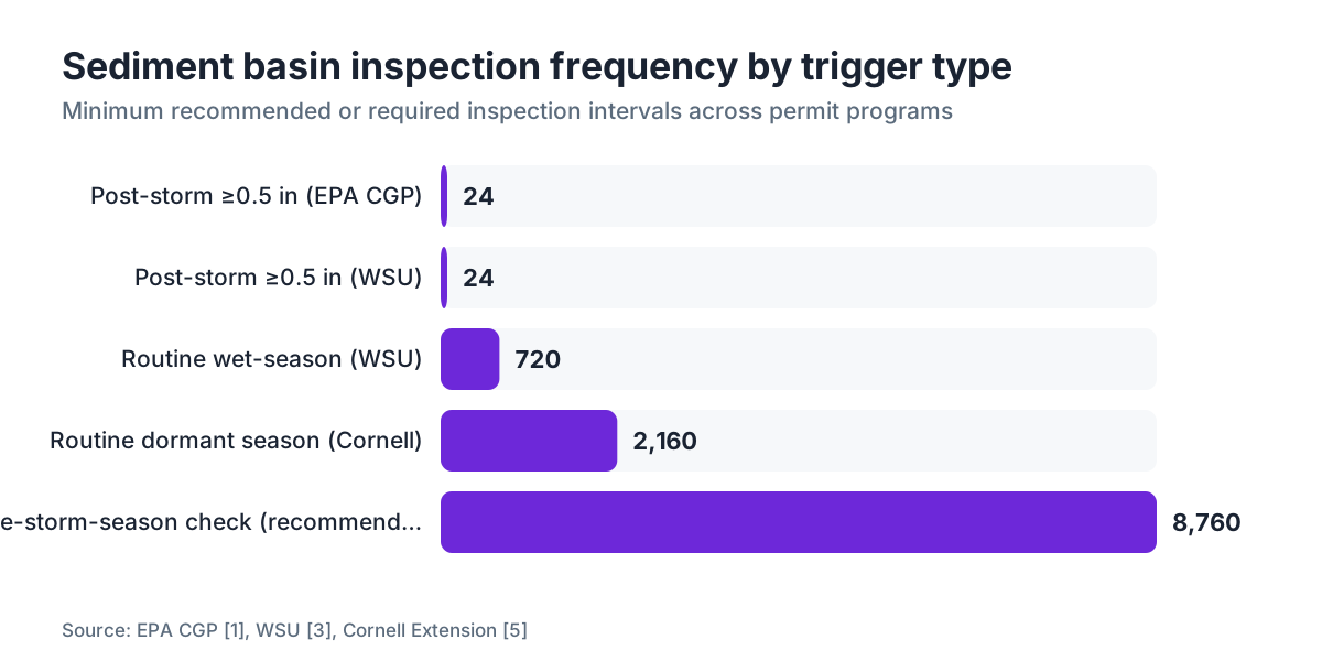
The EPA's CGP (the federal baseline for land-disturbing activities of one acre or more) requires inspections at least every seven days, and within 24 hours of any storm event producing 0.5 inches or more of rainfall. [1] That's the floor for active construction phases. Operating vineyards covered under agricultural general permits often run on different schedules.
California's Irrigated Lands Regulatory Program requires growers enrolled in a third-party coalition to have BMPs in place and documented, with inspection frequency tied to the risk tier of the operation. Higher-risk operations face more frequent documentation. [2]
Washington vineyards under agricultural stormwater rules generally do post-storm inspections. WSU viticulture guidance recommends inspecting after any storm over 0.5 inches in a 24-hour period, plus at least monthly during the rainy season, which runs roughly October through April in the Pacific Northwest. [3]
Cornell Cooperative Extension recommends at least twice-per-season inspection for dormant-season basins, plus a look after every significant storm. [5]
Here's what I'd actually do. Set a calendar reminder for monthly inspections from first rain through bud break. Add a trigger for any rainfall over 0.5 inches. Document every one, whether or not you found a problem. A log showing 18 inspections with no issues is far more useful to a regulator than one showing 3 inspections where everything was fine.
| Trigger | Minimum recommended frequency | Source |
|---|---|---|
| Routine (non-storm) | Monthly during wet season | WSU |
| Post-storm (≥0.5 in/24 hr) | Within 24 hours | EPA CGP |
| Post-storm (construction sites) | Within 24 hours | EPA CGP |
| Semi-arid regions, dry season | Before and after dormancy at minimum | Cornell Extension |
| High-risk ILRP tier (CA) | Per coalition-approved farm plan | CA SWRCB |
What does a completed sediment basin inspection form look like?
A lot of operators ask for a template, and that's a fair ask. Here's what a complete record entry looks like in plain language, field by field.
Date: October 14, 2024
Time: 0830
Inspector: Maria Fuentes, Vineyard Manager
Basin ID: SB-2 (East Drainage, Block 6-A)
Weather at inspection: Overcast, 48°F, no active precipitation
Triggering event: Rainfall event October 13, 1.1 inches in 18 hours (on-site gauge)
Sediment depth (measured): 14 inches from basin floor
Design storage depth: 36 inches (from installation record dated 11/2021)
Sediment fill level: About 39% of design volume. Below the one-third trigger for required cleanout, but entering the monitoring zone.
Freeboard remaining: 22 inches
Inlet condition: Clear, no debris blockage observed
Outlet/riser condition: Perforated riser intact, no piping or undercutting visible
Berm condition: One small erosion rill on south face, roughly 8 inches deep and 12 inches long
Vegetation: Berm cover thin on south and west faces after summer drought stress
Corrective action required: Repair south-face rill. Overseed berm faces with perennial ryegrass before next rain event.
Corrective action completed: Rill filled and compacted with native soil October 15, 2024. Overseeded October 16, 2024. M. Fuentes.
Signature: [signed] Maria Fuentes
That's it. It's not long. The whole thing takes maybe 20 minutes per basin including the walk out there. The discipline is showing up regularly and writing down what you actually see, not what you expect to see.
How do you track sediment accumulation over time and know when cleanout is needed?
This is the part most vineyard operators skip, and it's where records earn their keep.
You need two numbers: the design storage depth (from your installation plan or as-built survey) and the current sediment depth. The ratio tells you where you are. Most BMP guidance, including UC Davis Center for Watershed Sciences materials, cites one-third of design volume as the trigger for scheduling cleanout. [4] Some programs use one-half. Check your permit.
Measure sediment depth with a measuring rod or marked staff. Drive it into the basin floor at the same spot every time. Mark that point with a stake so you're comparing the same location year to year. Record the number. That's the whole job.
Plot those numbers over time and you learn something genuinely useful: your accumulation rate. Say you're adding 2 inches of sediment per major storm in a basin with 24 inches of design storage. That's roughly a 12-storm buffer before you're in trouble. Now you can schedule cleanout ahead of time instead of scrambling after a failure.
Cleanout records belong in the same file as inspection records. Log the date, volume removed (cubic yards if you can estimate it), disposal location, and who did the work. Sediment pulled from a basin can carry pesticide residues depending on your spray program, so check your state's disposal rules. California, for one, has specific guidance on sediment from basins in areas with documented pesticide use. [2]
If you're managing records across multiple blocks and multiple seasons, a spreadsheet or a field operations platform like VitiScribe makes it much easier to see accumulation trends at a glance instead of hunting through a binder.
What are common mistakes vineyards make when documenting basin inspections?
The most common one is not measuring anything. A log that says "basin looks fine" is almost worthless for compliance and completely worthless for planning. Regulators want numbers. So does your future self.
Second most common: inspecting after a storm but forgetting to log the storm that triggered it. You need the rainfall amount and the date. Without them, a post-storm inspection reads like a random routine check, and you lose the proof that you met the post-storm requirement.
Third: leaving the corrective actions column blank when you found a problem, then fixing it without writing it down. This is worse than not inspecting at all, because it creates a record that identified a deficiency with no documented response. An auditor who sees that pattern assumes the repair never happened.
Fourth: scattering records across places. Field notebooks, phone photos, emails to yourself. If you can't produce a coherent record during an audit, the records effectively don't exist. Pick one system and stick to it.
Fifth, and this one surprises people: skipping documentation of inspections that found no problems. A clean inspection is still a required inspection. Log it. "No deficiencies observed" is a complete and acceptable finding.
UC Davis Center for Watershed Sciences work notes that documentation gaps rank among the most frequently cited deficiencies in agricultural water quality audits, ahead of actual water quality violations. [4] Keeping good records is genuinely easier than explaining why you didn't.
How long do you need to keep sediment basin inspection records?
Three years is the federal baseline. The EPA's NPDES permit program requires that stormwater pollution prevention plan (SWPPP) records, which include BMP inspection logs, be kept for at least three years from the date of the inspection. [1]
Many state programs match or beat that. California's Irrigated Lands Regulatory Program requires records be available for inspection by the Regional Water Quality Control Board on request, and the practical expectation is three to five years of accessible records. [2]
For vineyards, I'd keep them longer. Sediment basin performance is highly site-specific. A five-year log of accumulation rates, storm responses, and repair history is worth a lot when you're deciding whether to expand a basin, move it, or argue with a regulator about whether your current design holds up. That institutional memory has real operational value past compliance.
Store records so they're actually findable. Physical binders labeled by year and block work. Digital records backed up off-site work better. The worst outcome is a box of field notebooks where the 2020 entries are unreadable because someone used a pen that bled in the rain.
Are there specific permit programs vineyards need to know about for sediment basin documentation?
Yes, and they overlap in ways that get confusing.
At the federal level, the Clean Water Act Section 402 NPDES program is the foundation. Vineyards that disturb more than one acre of land (for planting, grading, road construction) need coverage under a general permit or an individual NPDES permit, and that permit spells out BMP documentation requirements. [1]
California operators in irrigated agriculture fall under the Irrigated Lands Regulatory Program (ILRP), run by the State Water Resources Control Board. Most growers join a third-party coalition (like a Central Valley or North Coast regional coalition), which carries its own farm plan requirements. Those plans reference sediment basins as required BMPs in most drainage scenarios. [2]
Washington growers may fall under the state agricultural stormwater rules or, if they're in a surface water management district, local requirements run by county conservation districts. WSU viticulture programs are the practical reference most Washington operators lean on. [3]
Oregon's Department of Agriculture runs an Agricultural Water Quality Management program. The Columbia Gorge Agricultural Water Quality Area Plan specifically addresses vineyard erosion control and requires documentation of BMP implementation. [6]
New York growers in regulated watersheds (the Lake Erie and Finger Lakes regions in particular) may be subject to Agricultural Environmental Management (AEM) requirements. Cornell Cooperative Extension provides the framework there. [5]
The EPA's Worker Protection Standard (WPS) is separate from water quality compliance, but it also generates records that can be audited on the same visit. So keep your water quality and WPS records in one organized system to make any inspection go faster. [7]
How do you set up a simple sediment basin inspection logging system?
You don't need software to do this well, though software helps at scale. Here's the minimum viable system.
Build a template with every required field (see the list in the second section above). Print 20 copies per basin per year. Keep them in a waterproof sleeve in the field or a dedicated binder in the office. When you inspect, fill one out, sign it, date it, and file it the same day.
Keep a separate page for each basin as an accumulation tracking log: date, sediment depth, freeboard, and a running note of any corrective actions. This page is what you hand an auditor who wants to understand basin performance over time.
For storm tracking, keep a rain gauge log or pull readings from a nearby CIMIS station (in California) or AgWeatherNet station (in Washington), and note the source and reading alongside each post-storm inspection. [8][9] That removes any argument about whether a storm cleared the 0.5-inch inspection trigger.
Managing more than three or four basins, or several vineyard properties? A digital system starts to pay off. Record-keeping platforms built for vineyard operations let you attach photos, timestamps, and GPS coordinates to each entry. That level of detail is increasingly expected in higher-risk permit categories, and it's genuinely useful for tracking damage patterns across years. VitiScribe is built for exactly this kind of compliance record-keeping across vineyard operations, including BMP inspection logs with photo attachment and storm-event triggers.
Whatever system you use, the one that actually gets filled out is the right one.
What should you photograph during a sediment basin inspection, and how do you store photos as part of the record?
Photos aren't strictly required by most permit programs, but they help enormously and turn up more and more in audits. A dated, geotagged photo is hard to dispute. A written description of erosion damage is easy to misread or second-guess.
At minimum, photograph the inlet structure, the outlet structure, the berm from each face showing vegetation condition, any deficiencies you're documenting, and the measuring rod in place showing sediment depth. That's five to eight photos per inspection.
File photos with the written record. On paper, print the best two or three and staple them to the form, or keep a photo log with date-matched filenames. Going digital, attach them straight to the record entry.
Phone photos work fine. The one thing that matters is that the filename or metadata carries the date. If your phone doesn't embed dates in filenames, rename the files right after the inspection using a simple convention like SB2_2024-10-14_inlet.jpg. That takes 90 seconds and saves a pile of confusion later.
One caution: if you photograph a deficiency, the photo creates a record that the deficiency existed. Make sure your corrective action documentation matches. An undocumented repair on a documented problem is a red flag.
How does a sediment basin inspection record differ from a general stormwater inspection record?
A stormwater inspection record covers every BMP on the site, not the sediment basin alone. Your SWPPP (or equivalent farm plan) probably lists a range of practices: straw wattles, check dams, vegetated filter strips, road drainage controls, sediment basins. A general stormwater inspection log touches all of them.
A sediment basin inspection record is the detailed subset for that one structure. Think of the general stormwater log as the index and the basin record as the chapter. Both need to exist, and they need to agree. If your general log says all BMPs were inspected on a given date but there's no matching basin record, that's a documentation gap.
For most small to mid-size vineyards, the practical move is a single inspection form with a section for each BMP on the property, the sediment basin section being the most detailed. That keeps everything in one document per inspection date while still capturing basin-specific measurements.
Larger operations, or those with multiple drainage watersheds, often find it cleaner to keep separate basin records and reference them from the master stormwater log. Either way works as long as the records are complete and findable.
Frequently asked questions
Can I use a phone app to log sediment basin inspections, or does it have to be on paper?
Most permit programs accept digital records as long as they're legible, dated, signed (or tied to an authenticated login), and can be printed on request. Check your specific permit language. California's ILRP and the EPA's CGP both accept digital records. The practical requirement is that records be producible during an audit, which means organized and backed up, not sitting in your phone's camera roll.
What happens if I miss a required post-storm inspection?
Document it anyway, as soon as you can, and note why it was late. A late record beats no record. If the basin wasn't accessible or conditions were unsafe, log that. Regulators generally tell the difference between a missed inspection with no documentation and a delayed one with an honest explanation. Repeat misses drive enforcement action, not a single late entry.
Do sediment basin inspection records need to be signed by a certified professional?
Not in most agricultural settings. The EPA's CGP requires that inspections on construction sites be done by a 'qualified person,' defined as someone knowledgeable in the principles of erosion and sediment control, but that doesn't require a licensed engineer or certified professional. Many state agricultural permit programs require only the grower or a designated employee. Check your permit's definition of 'qualified inspector.'
How do I document a sediment basin that failed during a storm event?
Document thoroughly and immediately. Record the date, event size, failure mode (overtopping, berm failure, outlet blockage, and so on), estimated volume of sediment discharged, and whether discharge reached a water body. Take photographs. Note corrective actions underway. Many permits require notifying the regulatory agency when a BMP failure discharges to surface water, so check your permit's reporting requirements before assuming documentation alone is enough.
Is there a standard federal form for sediment basin inspection records?
No. The EPA doesn't publish a standard form. Some states provide optional templates through their environmental agencies or conservation districts. NRCS (Natural Resources Conservation Service) has design standards for sediment basins (Practice Standard 350) but not an inspection form. Most vineyard operators use a custom form built from their permit's required fields, or a form from their state's agricultural water quality coalition.
How much sediment can a basin hold before it needs to be cleaned out?
The typical trigger is when sediment fills one-third to one-half of the basin's design storage volume. This shows up in both NRCS Practice Standard 350 and most state BMP manuals. At one-third fill the basin still works, but scheduling cleanout gets urgent. At one-half, performance is well degraded and cleanout should happen before the next major storm season. Measure with a staff gauge at every inspection so you always know your current percentage.
Do I need to keep records of sediment basin cleanouts separately from inspection records?
Yes. Cleanout records should note the date, volume removed (cubic yards is the standard unit), equipment used, labor hours, disposal location, and who did the work. These records support maintenance cost tracking and show regulators you're responding to documented deficiencies. If the removed sediment goes to a specific field or off-site location, document that too, especially if your operation uses pesticides.
What if my sediment basin doesn't have a formal design document and I don't know the design storage volume?
Get it surveyed. A basic topographic survey of the basin gives you the volume. Some NRCS offices and conservation districts help with this at low or no cost for enrolled producers. Until you have design data, you can still document inspections using absolute measurements (sediment depth, freeboard, surface area) rather than percentages. Missing design records is a gap worth closing before an audit, not one to ignore.
How do I calculate freeboard and why does it matter for inspection records?
Freeboard is the vertical distance between the current water surface and the top of the berm or spillway. Measure it with a staff gauge or tape. It matters because low freeboard means overtopping risk in the next storm. Most BMP guidance recommends at least 1 foot of freeboard at all times. Log it as a number, not a description. 'Freeboard: 18 inches' is useful. 'Looks okay' is not.
Can photos replace written inspection records?
No. Photos supplement written records but can't replace them. A photo shows condition at a moment in time but doesn't capture the inspector's name, the triggering storm event, sediment depth, freeboard, or corrective actions. Regulators expect both. The practical approach is to take photos at every inspection and attach them to the written form, treating the photo as evidence and the form as the legal record.
What's the difference between a sediment basin and a sediment trap, and do they have different documentation requirements?
NRCS distinguishes them by size and design life: a sediment trap (Practice Standard 350A) is a smaller, temporary excavated pit or earthen embankment, while a sediment basin (Practice Standard 350) is a larger permanent or semi-permanent structure with an engineered outlet. Both require BMP inspection documentation under most permit programs, but sediment basins usually face stricter documentation because of their larger drainage area and longer design life.
Do I need to inspect sediment basins in summer when there's no rain?
Most permit programs don't require post-storm inspections in dry periods with no qualifying rainfall. But a dry-season inspection before the first fall rains is strongly recommended and required by some programs. Use it to clear debris from inlets and outlets, repair any berm damage from summer vineyard traffic, check vegetation cover, and confirm sediment depth before storm season begins. Document it like any other inspection.
How do I handle inspection records for a sediment basin shared between two vineyard operations?
Both operators should keep their own records referencing the shared structure. Put it in writing (even a simple agreement): who's responsible for inspections, what the schedule is, and how corrective actions get assigned and documented. Each operator's permit compliance rides on their own records. A shared basin with unclear responsibility is a compliance risk for both parties.
Sources
- EPA, Construction General Permit (CGP), NPDES Stormwater Discharges from Construction Activities: NPDES CGP requires BMP inspections at least every seven days and within 24 hours of a storm event producing 0.5 inches or more of rainfall; records must be retained for at least three years.
- California State Water Resources Control Board, Irrigated Lands Regulatory Program: California ILRP requires growers to document BMP implementation and maintain records available for Regional Board inspection; sediment basins are listed as required BMPs in most drainage scenarios.
- Washington State University, Viticulture and Enology program resources: WSU viticulture guidance recommends post-storm inspections after any rainfall exceeding 0.5 inches in 24 hours and monthly inspections during the October through April wet season for Washington vineyards.
- UC Davis Center for Watershed Sciences: Documentation gaps are among the most frequently cited deficiencies in agricultural water quality program audits; one-third design volume is the standard cleanout trigger cited in UC Davis BMP guidance.
- Cornell Cooperative Extension: Cornell Extension recommends a minimum of twice-per-season inspection for dormant-season sediment basins plus inspection after every significant storm event.
- Oregon Department of Agriculture, Agricultural Water Quality Management Program: Oregon's Columbia Gorge Agricultural Water Quality Area Plan requires documentation of BMP implementation for vineyard erosion control, including sediment basins.
- EPA, Agricultural Worker Protection Standard (WPS): The EPA Worker Protection Standard generates records audited alongside water quality compliance records during regulatory site visits to agricultural operations.
- California Department of Water Resources, CIMIS (California Irrigation Management Information System): CIMIS provides station-level rainfall data that vineyard operators can cite as the source for storm-event measurements in inspection records.
- Washington State University, AgWeatherNet: WSU AgWeatherNet provides localized hourly precipitation records used by Washington vineyard operators to document qualifying storm events in BMP inspection logs.
- EPA, NPDES Stormwater Program: The NPDES program under Clean Water Act Section 402 requires permit coverage for land-disturbing activities of one acre or more, including vineyard planting and grading, with mandatory BMP documentation.
Last updated 2026-07-11