How to set up a vineyard block map for spray record cross-referencing

TL;DR
- A vineyard block map gives every distinct growing unit a unique ID, and that ID then appears on every spray record, application log, and worker safety notice.
- When an inspector asks what went on Block 7 on a given date, you pull one list and answer in seconds.
- The map is the index.
- The spray records are the pages.
Why does a vineyard block map matter for spray records?
Pesticide records with no spatial reference are close to worthless at audit time. You know you sprayed sulfur on July 12. But which blocks? All of them? Half? Just the ones with powdery mildew pressure near the creek draw? Without a map that ties a block ID to a physical location, you're reconstructing history from memory, and memory loses every argument with a California Department of Pesticide Regulation inspector or an organic certifier.
The EPA Worker Protection Standard (WPS) requires that application records include the location of the treated area in enough detail that workers can identify it [1]. That phrase, "in enough detail," is exactly where most small operations fall down. A field name or a loose description like "the east side" doesn't cut it when a worker needs to know whether a block is safe to enter after a restricted-entry interval.
Block maps fix this. Each block gets a stable, unique ID. The ID goes on the spray record. The map holds the block's boundaries, acreage, and site notes. Together the two documents meet the WPS location requirement and turn cross-referencing into a 30-second job.
What information does a vineyard block map need to include?
A useful block map carries six things for each block: a unique block ID, the block or common field name (some people use numbers, some use names, use both), the acreage, the variety or varieties planted, the row orientation, and a GPS-referenced boundary or at least a georeferenced polygon drawn over an aerial image.
For spray record work specifically, add the water sources in or next to each block (they drive label buffer requirements), the organic or transitional status, the irrigation type (drip versus overhead changes how some products go on), and any neighbor or buffer zone that triggers a setback.
Here's the field set that holds up in practice:
| Field | Why it matters for spray records |
|---|---|
| Block ID (e.g., BLK-04) | Primary key that links the map to every spray record |
| Variety | Some products carry variety-specific use restrictions |
| Acres | Needed to calculate total product applied per site |
| Organic status | Blocks accidental conventional application on certified ground |
| Water body proximity | Triggers buffer requirements on many labels |
| Row orientation | Feeds drift risk and equipment pass direction |
| Neighboring land use | Schools and residences trigger extra label requirements |
| Soil series (optional) | Useful for pre-emergent and soil-applied products |
University of California Cooperative Extension recommends pesticide application records that include the treated acreage, the specific field or block, and the application method, so the records support re-entry interval tracking and neighbor notification [2].
How do you actually create the map, low-tech and high-tech?
You don't need a GIS department. You need one stable reference document that every person writing a spray record can look at and trust.
The lowest-tech version is a printed aerial photo (pull one from Google Earth, the USDA Web Soil Survey, or your county assessor's parcel viewer) with block boundaries drawn in marker and labeled with your block IDs. Laminate it. Tape it inside the spray record binder. Done. This genuinely works.
One step up: draw your blocks in Google My Maps (free), print it or export a PDF, and also export the KML so you have a digital backup. You can attach variety, acres, and organic status to each polygon right in the tool.
Farm management software takes it further. Most platforms let you draw block polygons and hang attribute tables off them, and the block ID in the software becomes the same ID on your printed spray records. In VitiScribe, the block map layer feeds straight into the application log, so the block ID auto-populates when you pick a treatment area. That single move kills the most common transcription error in manual records.
Washington State University Extension's pest management guidance makes the point plainly: whatever system you use, the block identifier on the spray record has to match the identifier on the physical map with no ambiguity [3]. If the map says "Block 4-N" and the records say "North Block 4," you've built a cross-referencing failure and just haven't hit it yet. Pick a naming convention and hold the line from day one.
What block ID naming system works best?
The best naming convention is the one your applicators will write correctly every single time. That rules out anything long or anything two blocks share.
Three systems earn their keep. Sequential numbers (Block 1 through Block N). Alphanumeric codes (BLK-01, BLK-02). Or a prefix-number system that encodes a property section (NE-01 for northeast section, block one). The prefix version pays off when you're running multiple ranches or a large property with distinct geographic zones.
Avoid near-twins. "East Block" and "East North Block" will get swapped. Avoid names tied to temporary conditions: "The New Block" stops meaning anything after two seasons. And avoid names that live only in someone's head, like a nickname the last manager used that never reached paper.
Once the convention is set, it goes everywhere. The physical map. The digital map. The spray record header. The equipment calibration log. The scouting report. The harvest log. Renaming blocks mid-season or mid-record-year is a compliance headache you create for yourself. Lock the names before the season starts and treat them as fixed for that record year.
How do you link the block map to a spray record template?
The block ID is the key that joins your map to your records. Every spray record form needs a dedicated field for it, separate from any field name or general location line. A field for the block ID exactly as it reads on the map.
A complete spray record entry for cross-referencing carries the date and time of application, the applicator name and license number (required by most state pesticide rules), the product name and EPA registration number, the target pest, the application rate, the total product applied, the block ID, the treated acreage, the REI (restricted-entry interval) end date and time, the PHI (pre-harvest interval) and projected harvest date, and wind speed and direction at application.
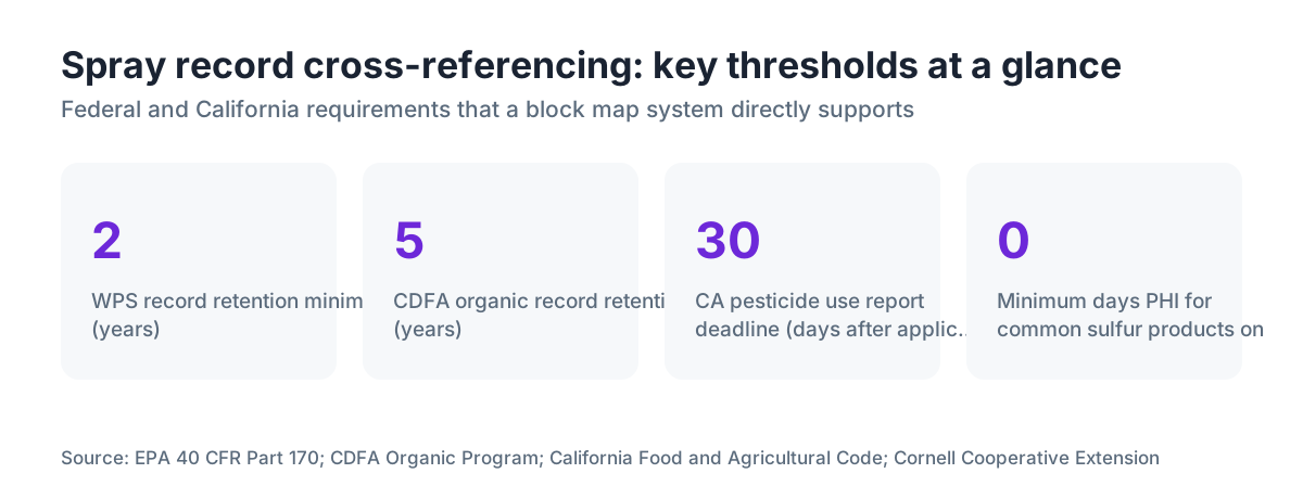
California requires pesticide use reports to reach the county agricultural commissioner within one month of application, and those reports need the legal description or location of the treated site [4]. If your spray record already carries the block ID, and your block map ties that ID to a legal description, building the commissioner's report is a copy job.
For the cross-reference to hold up at audit time, build an index. A simple spreadsheet where every row is a block ID and the columns are the dates that block got treated. One glance gives you the full history for any block. Cornell's Integrated Pest Management program recommends this kind of summary table as a season-end compliance document [5].
What are the EPA Worker Protection Standard requirements for location records?
The WPS, codified at 40 CFR Part 170, requires agricultural employers to keep application records that include the location of the treated area in enough detail for workers and handlers to identify it, along with the crop or site treated [1]. That location has to be accessible to workers before they enter a treated area after an REI.
The 2015 revision to the WPS took effect January 2, 2017, and it tightened the display side of this. Employers must post or otherwise make available information about applications, including the REI end date and time and the location of the treated area [11].
A block map handles this cleanly. Post the map in the central posting area (or keep it in the central record location), and have each posted application notice reference the block ID. A worker who can read the map can tell whether the block they're about to enter is under an active REI.
EPA's WPS guidance is blunt about liability: the agricultural employer is responsible if a worker enters a treated area during an REI, warned or not [1]. A block map tied to spray records is the paper that shows you communicated the location correctly.
How do you handle irregular blocks, mixed varieties, and subdivisions?
Real vineyards don't come in tidy rectangles. You'll have blocks split by a road, blocks with a patch of a different variety grafted in, blocks planted in phases across separate years, and blocks sitting on two or three soil types.
The clean rule: split anything that needs its own spray history into its own block ID. If the grafted-over patch in Block 6 is a different variety with different sulfur sensitivity, give it its own ID (say, Block 6A). If Block 12 straddles a certified-organic line, the organic and conventional portions each need an ID even though they touch.
Blocks with multiple varieties that always get identical treatment can share one ID. Just list every variety in the attribute table. Some certifiers and some state programs want a per-variety breakdown on records, so check your specific program before you assume one ID covers it.
Subdivisions show up most with spot treatments. You sprayed a powdery mildew hot spot in the northwest corner of Block 9, not the whole thing. Handle it by recording the treated acreage as a fraction of the block total and adding a note ("northwest corner, roughly 1.2 acres of 4.8 total"). No new block ID needed for a spot treatment. The record just has to be explicit.
How do you keep the block map current through vineyard changes?
A map that was right in year one and never touched since becomes a liability. Vineyards move. New plantings go in, tired blocks come out and get replanted, varieties change through grafting, certification status shifts, and blocks get split or merged.
Keep a version history. When you update the map, hold onto the old version with a date range showing when it was current. Spray records from 2021 get cross-referenced against the 2021 map, not the 2024 one. If block IDs changed between seasons, keep a plain translation table: "What was Block 3 in 2021 became Block 3A and Block 3B in 2023."
Build a habit. Review and reconcile the block map at the end of each dormant season, before the new year's spray records start. Fix acreages that changed. Add new blocks. Note certification changes. Print a fresh master copy, date it, and file the old one.
Digital maps make versioning easier. Save a dated copy of the KML or shapefile at the start of each season. Cloud storage with version history (Google Drive, Dropbox) does this in the background, but take intentional dated snapshots anyway so the versioning is obvious to anyone opening the folder later.
What does an audit-ready spray record cross-reference system look like?
Inspectors, organic certifiers, and buyers running farm audits all want the same thing: a complete treatment history for any block or product, produced without hesitation. The faster and cleaner you produce it, the shorter the audit runs.
An audit-ready system has three parts working together. A current, dated block map with every block labeled and described. Spray records organized by date, with the block ID sitting prominently on each entry. And a summary index that lets you look up any block and see every application that season, or look up any product and see every block it touched.
That third piece is what most operations are missing. You can build it in an afternoon. Rows are blocks, columns are application dates, cells hold the product name or code. A second tab flips it: rows are products, columns are blocks. This is the document you hand the auditor first. If it reads clean and current, the detailed records behind it rarely get picked apart.
For organic work, the California Department of Food and Agriculture's organic program requires records be kept for five years and that they let an inspector verify no prohibited substances hit certified ground [6]. A block map tied to spray records makes that verification quick. Without one, the inspector is taking your word for it.
VitiScribe's record-keeping tools are built for exactly this, with block IDs linking map layers to application logs and summary exports formatted for common certifier audits.
How does block mapping affect pre-harvest interval tracking?
The pre-harvest interval (PHI) is the number of days that must pass between the last application of a specific pesticide and harvest of the treated crop. Blow a PHI and you've got a residue violation, which can mean rejected loads, fines, and in California, mandatory reporting to the Department of Pesticide Regulation.
A block map with accurate acreage and variety data feeds PHI tracking directly, because PHIs are product-specific and sometimes variety- or crop-group-specific. If you sprayed a product with a 14-day PHI on Block 5 and your expected pick date there is September 20, you need the last application date for that block, not for the whole vineyard.
When every spray record carries a block ID, the query is instant: show me all applications on Block 5 after August 1, with their PHIs. Without the block ID, you're scanning every record from the season by hand, guessing which ones touched Block 5.
Cornell Cooperative Extension notes that PHI violations in grapes usually don't come from growers spraying near harvest on purpose. They come from losing track of which products went on which blocks [5]. Block map cross-referencing is the direct fix.
How do you train employees to use block IDs correctly on spray records?
A block map is only as good as the records linked to it, and the records are only as good as the people filling them out. Applicator error, meaning the wrong block ID or a block name written in place of the ID, is the single most common failure in cross-referencing systems.
The best fix is to make the block ID hard to get wrong. A dropdown of valid block IDs on a digital form eliminates transcription errors outright. On paper, print the block ID list on the form itself, or clip a laminated quick-reference card to every spray record clipboard.
Walk new employees through the map before their first application. Standing in the block, pointing to it on the map, and reading the ID out loud beats any classroom session. Make sure they understand that writing "south block" instead of "BLK-04" creates a record that can't be cross-referenced.
For Spanish-speaking employees, who make up most of the vineyard workforce in California and much of the Pacific Northwest, translate the block ID reference card. The EPA WPS requires pesticide safety information be provided in a language the worker understands [1]. Block maps and their reference materials fall under the same rule of practical access.
Frequently asked questions
Does California law require a vineyard block map for pesticide records?
California doesn't spell out a map requirement, but its pesticide use reporting rules (California Food and Agricultural Code Section 12981) require records to include the legal description or address of the treated site, plus county, commodity, and acreage. A block map tying your block IDs to legal parcel descriptions is the most reliable way to meet that consistently. County agricultural commissioners can reject records that can't be spatially verified.
How many blocks should a small vineyard have?
There's no minimum or maximum. The right number is however many distinct treatment units you actually manage. If you always spray the whole property with the same program, one block is defensible. If different sections get different products, timing, or rates, those sections need separate IDs. Most 5-to-20-acre winegrape operations land at 4 to 15 blocks. Over-splitting adds paperwork with no compliance payoff. Under-splitting hides your real treatment history.
Can I use Google Earth to draw my block map?
Yes. Google Earth Pro (free on desktop) lets you draw polygons over aerial imagery, label them, and export as KML. The measurement tool gives acreage estimates usually within 2 to 5 percent of a surveyed figure, which is close enough for spray records. Google My Maps is a simpler browser option. Export and save a PDF dated to the start of each season so you keep a stable reference document.
What's the difference between a field map and a block map in vineyard record-keeping?
In daily use the terms swap freely, but the distinction that matters is whether the map is georeferenced and formally tied to your records. A sketch on a napkin with field names is a field map. A block map, for compliance, should carry stable block IDs, documented acreages, variety information, and a version date. The spatial reference (GPS coordinates or a georeferenced aerial image) is what makes it audit-ready.
How often do I need to update my vineyard block map?
Review it once a year during dormancy, before the new spray season starts. Update it right away if you add plantings, pull a block, change certification status on any parcel, or split a block for management reasons. Keep dated copies of every prior version. Past-season spray records should be cross-referenced against the map that was current when they were written, not the current one.
How does block mapping help with organic certification audits?
Certifiers need to verify no prohibited substances hit certified ground. A block map showing organic versus transitional versus conventional parcels, with block IDs tied to spray records, lets an inspector check any application against the certified boundary in minutes. Without spatial documentation, the inspector relies on your word alone. CDFA's organic program requires five years of record retention, so the map needs to be versioned and archived alongside the records.
What should I do if a block spans two different certified organic statuses?
Split it into two block IDs. Even if the block is physically continuous, any parcel with different certification status needs its own record trail. Use a clear convention, for example BLK-07-ORG and BLK-07-CONV. Draw the boundary on the map exactly where the certification line falls. Some certifiers require a survey, or at least a GPS-traced boundary, to accept a split like this.
Can spray records and block maps be kept digitally, or do they need to be on paper?
Most state pesticide rules and the federal WPS allow electronic records as long as they're accessible for inspection and can be printed on request. California accepts electronic pesticide use reports through the county agricultural commissioner's system. The key is that records stay retrievable, legible, and preserved for the retention period, which is two years under WPS (40 CFR 170.309) and two years under California law, though organic certification typically wants five years.
What is the EPA WPS requirement for posting pesticide application information near vineyard blocks?
Under 40 CFR 170.309, agricultural employers must post application information in a central location workers can reach before entering treated areas. The posting must include the product name, EPA registration number, the REI, and the location of the treated area. A block map posted in the central location, referenced by block ID on the application notice, satisfies the location requirement. The information stays posted until the REI expires and the area has been ventilated or dried.
How do I cross-reference spray records when the same block is treated multiple times in a season?
Each application gets its own record entry with its own date, but every entry for that block carries the same block ID. At season's end, sort or filter by block ID for the full history. This is where a seasonal summary index earns its keep: block IDs as rows, application dates as columns, so you see at a glance how many times Block 6 was treated and with what.
Do I need GPS coordinates for every block corner, or is a rough aerial sketch good enough?
For most state pesticide records and WPS compliance, a clearly labeled aerial image with boundaries drawn and acreages noted is enough. GPS coordinates for block corners aren't legally required in most jurisdictions. But if you enroll in USDA programs (like the Conservation Reserve Program or EQIP), pursue certain certifications, or use precision agriculture tools, GPS-referenced boundaries will be required. A GPS boundary walk takes a few hours and pays off for years.
What happens if my spray records and block map don't match during an inspection?
Discrepancies between spray records and block maps are among the most common findings in pesticide use inspections. Consequences run from a warning and required correction up to fines, and in California, mandatory reporting of the discrepancy to the county agricultural commissioner. Under CDFA organic certification, repeated discrepancies can trigger suspension or revocation. The fastest way to close a discrepancy is a version-dated map plus a clear record of when block IDs were assigned or changed.
How does WSU Extension recommend structuring vineyard pesticide records for cross-referencing?
WSU Extension's viticulture and pest management guidance recommends keeping a field map as a companion document to spray records, with consistent field or block identifiers used across all records. The guidance stresses that the block identifier on the spray record must match the map without ambiguity, and that records should carry enough spatial information for a third party to reconstruct which areas were treated without interviewing the applicator.
Sources
- EPA, Agricultural Worker Protection Standard (40 CFR Part 170): WPS requires pesticide application records to include the location of the treated area in enough detail for workers to identify it; posting requirements include REI end date and treated area location
- UC Statewide Integrated Pest Management Program: UC recommends spray records include treated acreage, the specific field or block, and method of application for re-entry interval tracking
- WSU Extension, Pacific Northwest Pest Management Handbooks: Block identifier on spray records must match identifier on physical map without ambiguity
- California Department of Pesticide Regulation, Pesticide Use Reporting: California requires pesticide use reports submitted to county agricultural commissioner within one month of application, including the legal description or location of treated site
- Cornell Cooperative Extension, New York State Integrated Pest Management Program: PHI violations in grapes most often occur because growers lose track of which products were applied to which specific blocks; summary cross-reference tables recommended as season-end compliance documents
- California Department of Food and Agriculture, State Organic Program: CDFA organic program requires records be kept for five years and enable an inspector to verify that prohibited substances were not applied to certified ground
- California Food and Agricultural Code Section 12981: California law requires pesticide application records include the legal description or address of treated site, county, commodity, and acreage
- USDA National Agricultural Library: Federal and state pesticide record-keeping requirements for restricted-use pesticides, retention periods, and required data fields
- USDA Web Soil Survey: Publicly available aerial imagery and soil series data usable for block boundary mapping
- UC Agriculture and Natural Resources, Viticulture Resources: Block-level record-keeping practices for California winegrape production
- EPA, Pesticide Worker Safety (Revised Worker Protection Standard): 2015 WPS revision effective January 2 2017 strengthened requirements for posting application information including location of treated area accessible to workers before they enter
Last updated 2026-07-09