Native plant restoration documentation adjacent to vineyard operations
TL;DR
- Vineyards with native plant restoration areas next to their blocks need documentation covering species inventories, pesticide buffer records, permit conditions, and grant deliverables.
- Good records protect you during agency audits, prove compliance with California, Oregon, or Washington habitat rules, and are often a condition of USDA NRCS cost-share money.
- Start with a georeferenced species list and link it to your spray records.
Why do vineyards need to document native plant restoration at all?
The short answer: three different agencies may ask for it at the same time, and each wants something slightly different.
Farm bill programs, state water board permits, and local land-use conditions can all require that a vineyard keep a vegetated buffer or restoration planting next to its blocks. When those plantings qualify for USDA Natural Resources Conservation Service (NRCS) cost-share programs like the Environmental Quality Incentives Program (EQIP) or the Regional Conservation Partnership Program (RCPP), the agency writes specific monitoring and documentation conditions into the payment schedule [1]. Miss a documentation deadline and you can lose a payment or trigger repayment of funds you already banked.
State-level drivers add another layer. California's State Water Resources Control Board requires farms above certain irrigated-acreage thresholds, or in certain priority watersheds, to show that riparian and upland buffer vegetation is being maintained, not removed [2]. Oregon and Washington run their own agricultural water quality programs with similar buffer provisions. None of these agencies want identical paperwork, which is exactly why you need a system that captures the information once and can be reformatted for each requester.
The pesticide side is just as concrete. The EPA Worker Protection Standard (WPS) and the separate label rules around sensitive areas mean that if a restoration planting sits inside the label-defined buffer distance from a spray application, you need to document that you knew the boundary was there and respected it [3]. If you spray in a county that requires pesticide use reports, an application near a restoration area with a rare-species designation may need extra notation. Thin records there are real liability.
What records does a typical native plant restoration program require?
The core set has six pieces. You don't need fancy software to handle them, but you do need consistency.
- A georeferenced species inventory. This is a list of the plant species in the restoration area, tied to GPS coordinates or a mapped polygon. Most NRCS practice standards for upland wildlife habitat or riparian buffers (Practice Standard 390, 391, or 643) require a baseline inventory at installation plus at least one monitoring count per year [1]. Note whether each species is native, introduced, or invasive. Introduced annuals in a planting are not automatically a problem, but your notes should show you're tracking cover percentages over time.
- A restoration planting map. A hand-drawn sketch won't satisfy most agency auditors. You need something that shows the planting boundary, the adjacent vineyard blocks, and any waterways or sensitive areas, with a scale and a north arrow. A PDF export from a GIS layer, or even a high-resolution screenshot from a web mapping tool with your polygons drawn on it, is usually fine. Store it with a date stamp.
- Pesticide application records that reference the restoration boundary. This is the piece most vineyard managers skip. Your spray records should note the distance from the treated block to the restoration edge, the wind speed and direction at application, and confirmation that you read the label for buffer requirements. The EPA WPS requires application records to include the product name, EPA registration number, location, date, time, and amount applied [3]. Adding a field for "adjacent sensitive area" and the measured distance costs nothing and proves you were paying attention.
- Irrigation records if the area is irrigated. This matters for establishment-phase plantings that draw supplemental water from your vineyard system. Some NRCS practice standards require documentation of irrigation events and volumes during the first two to three years after planting.
- Maintenance activity logs. Weeding, mowing outside designated periods, and any soil disturbance inside the restoration area all need logging. California Department of Fish and Wildlife Streambed Alteration Agreements often set explicit windows when no ground disturbance is allowed, usually to protect nesting birds, and your maintenance logs are how you prove you honored those windows [2].
- Photo documentation. Photos taken from the same fixed points, in the same season each year, are the easiest way to show vegetation change over time. Stake your photo points, record the GPS coordinates, and shoot every spring and fall. Put the date and point ID in the file names.
| Document | Typical update frequency | Who usually asks for it |
|---|---|---|
| Georeferenced species inventory | Annually | NRCS, state water boards |
| Restoration planting map | At installation, updated if area changes | NRCS, local permits |
| Pesticide application records with buffer notation | Every application event | EPA WPS, county ag commissioner |
| Irrigation logs (establishment phase) | Growing season | NRCS |
| Maintenance activity logs | Per event | CDFW, NRCS |
| Fixed-point photo set | Twice per year | NRCS, grant funders |
That table is a general frame. Read your specific permit conditions and payment schedule, because requirements shift by state and program year.
How do NRCS EQIP and RCPP programs shape your documentation obligations?
EQIP is the most common funding vehicle for on-farm habitat work in grape country, and it has real paperwork teeth. Sign an EQIP contract and you agree to install specific Conservation Practice Standards inside defined time windows and to document that you did [1]. Your local NRCS field office tells you which standards apply and what each one's "activity approval" documentation looks like.
For a native plant buffer next to a vineyard, you might be installing Practice Standard 390 (Riparian Herbaceous Cover), 391 (Riparian Forest Buffer), or 550 (Range Planting). Each has a technical specification sheet listing minimum species composition, minimum cover percentages, and monitoring requirements. The NRCS state office publishes these as PDFs, and UC Cooperative Extension maintains guidance on using EQIP for habitat plantings in wine grape regions [4].
The EQIP workflow usually runs like this. You install the planting. Your local NRCS conservationist does a practice-approval inspection, signs off, and releases the payment. After that, annual monitoring reports go to your NRCS contact by a set date, usually in fall. Miss the report and NRCS flags the contract as out of compliance. Two consecutive missed reports can trigger a repayment request.
RCPP works the same way but runs through a partnership, often a land trust, watershed council, or resource conservation district, and that partner may layer its own format on top of the NRCS base requirements. Ask the partnership coordinator for their monitoring template before you build your own.
One practical note. NRCS requires that all cost-shared practices stay in place and functioning for the life of the contract, usually five years for EQIP. Remove or substantially alter the planting inside that window and you owe the money back. Document any changes, even small ones, and tell your NRCS contact before you make them, not after.
What pesticide buffer rules apply near native plant restoration areas?
This is where spray record compliance and habitat documentation physically overlap, and where the stakes run highest.
Every pesticide label is a federal legal document under FIFRA [10]. When a label says "do not apply within X feet of water," or "do not apply where runoff could reach sensitive habitat," those are enforceable. A native plant restoration area next to your vineyard can qualify as sensitive habitat, especially if it holds state or federally listed plant species, wetland vegetation, or designated critical habitat for listed pollinators or birds.
The EPA WPS, as amended in 2015, requires applications be recorded with enough detail to reconstruct the conditions at spray time [3]. The record must include start and end times, the pesticide, the amount applied, the crop or site treated, and the applicator's name. Adding the restoration boundary distance is not a WPS requirement, but it's the thing that proves you looked before you sprayed if a county inspector ever questions a drift complaint.
California adds state requirements. The Department of Pesticide Regulation (CDPR) pesticide use report system makes growers report all applications by county and site, and certain restricted materials need a permit from the county agricultural commissioner [5]. If your restoration area holds a CDFW-designated sensitive natural community, or sits next to a critical habitat unit, talk to your county ag commissioner before applying any broad-spectrum insecticide or herbicide in adjacent blocks. The commissioner can tell you whether local conditions apply.
WSU Extension has published drift management guidance for Washington vineyards that fits buffer situations directly, including nozzle selection, application timing, and minimum wind speed thresholds near non-target vegetation [6]. Cornell's viticulture extension team has similar guidance for the Finger Lakes and Hudson Valley [7].
Build one field practice into your spray records. Before any application in a block next to your restoration area, measure the actual distance from the last vine row to the nearest restoration edge and log it. Use a measuring wheel or the GPS polygon from your restoration map. That number, recorded at the time of application, beats a retroactive estimate every time.
How do California, Oregon, and Washington differ in what they require?
The federal floor is the same everywhere: EQIP documentation, EPA WPS records, and FIFRA label compliance. State law and local programs stack on top, and they vary enough to matter.
California is the most prescriptive. The State Water Resources Control Board's Agricultural Order requires Tier 2 and Tier 3 irrigated operations, which sweeps in many larger vineyards, to submit annual reports covering vegetated buffers and their condition [2]. The CDFW Streambed Alteration Agreement process adds work-window and monitoring conditions for any restoration work in or near waterways. The CDPR pesticide use report system is the most detailed in the country and builds a searchable public record of every application by section of land. So your spray records and your restoration documentation need to agree with each other, because an auditor can cross-check both.
Oregon ties native buffer requirements to its Agricultural Water Quality Management Act. The Oregon Department of Agriculture (ODA) runs local area plans that set minimum vegetated buffer widths along streams and water bodies, usually 20 to 50 feet depending on stream type and adjacent slope [8]. Vineyards in priority water quality areas must build farm plans that include those buffers. Documentation of buffer condition is part of the farm plan compliance file.
Washington's Voluntary Stewardship Program (VSP) lets counties build watershed-specific approaches to protecting critical areas on farmland, native buffers included. Vineyards in VSP counties like Yakima or Walla Walla document their buffer plantings as part of their farm stewardship plans. WSU Extension provides technical help and monitoring templates for VSP participants [6].
If your operation crosses state lines, or you're chasing a multi-state RCPP grant, build a documentation system flexible enough to satisfy the most demanding state. Meet California's bar and the others fall into place.
How do you set up a practical record-keeping system for restoration areas?
The honest answer: a well-organized folder structure and a consistent field log will carry most small vineyard operations through an audit. You don't need specialized software to start.
Here's the folder structure that works. One master folder per restoration area, named with the location (block name or GPS centroid), holding subfolders for maps, species inventories, monitoring photos, maintenance logs, pesticide buffer records, and permit or grant documents. Every file gets a date in the file name. That's it. Searchable, portable, free.
Once you're managing more than two or three restoration areas, or the restoration documentation has to link directly to spray records from several blocks, a field operations platform that stores spatial data alongside spray records starts saving real time. VitiScribe, for instance, lets you attach a restoration polygon to adjacent block records so any spray log entry in that block automatically flags the proximity to the sensitive area. That kind of linkage is the thing that's genuinely hard to pull off in folders alone.
Whatever your system, three habits matter most. Log maintenance events the day they happen. Take photos before and after any soil disturbance. Date-stamp every document when you create it. Records written after the fact from memory are worth almost nothing in an audit, and they can create liability if they contradict other dated records.
UC Cooperative Extension has published a field monitoring workbook for riparian restoration projects in California with sample data sheets you can adapt for vineyard-adjacent areas [4]. Cornell's viticulture and enology program has similar templates for northeastern growers [7]. Both are free downloads, built around the metrics NRCS and state water boards actually ask for.
What species inventory methods are accepted by NRCS and state agencies?
This comes up constantly in the field, and the answer is more permissive than most growers expect.
NRCS does not require a certified botanist for routine annual monitoring of a cost-share planting. The practice standard for most upland and riparian habitat practices says monitoring data should come from a "qualified observer," which the local field office interprets case by case [1]. In practice, a vineyard manager who has done basic plant identification training (several UC Cooperative Extension workshops qualify) can serve as the qualified observer for annual photo-monitoring and cover estimates.
Two cover methods carry the load: line-point intercept and the Daubenmire frame. Both are simple field techniques with published protocols. Line-point intercept means stretching a measuring tape across the restoration area and recording the plant species (or bare ground or litter) directly under the tape at fixed intervals, usually every 50 centimeters [4]. The Daubenmire method uses a 0.5 by 1 meter frame and visual cover-class estimates. Both produce the percent-cover-by-species data that NRCS practice standards reference.
For the baseline inventory at installation, most NRCS field offices do want a fuller list, which may need help from a restoration ecologist or a plant ecologist at your local resource conservation district. One professional site visit to nail the baseline costs far less than redoing incomplete baseline documentation years later when you're trying to prove rare species were present from the start.
State water board protocols run on performance standards. California's Agricultural Order asks about buffer condition and percent cover of perennial vegetation, not species-level lists. Oregon's ODA farm plan monitoring is similar. Your NRCS species inventory is more detailed than the state water board needs, so finishing it satisfies both.
What happens if a restoration area contains a listed or rare plant species?
This is where documentation stops being routine paperwork and turns into legal protection.
If a state or federally listed plant species is present in your restoration area, or shows up after planting, you may have obligations under the federal Endangered Species Act (ESA) and the matching state statute. In California, that's the California Endangered Species Act (CESA), run by CDFW [2]. Oregon and Washington each run listed-species programs through their state fish and wildlife departments.
The key threshold under federal ESA Section 9 is whether your actions constitute a "take" of a listed species, which covers harm and harassment as well as direct killing. Documented good-faith management, including records that you knew a listed species was present and modified your practices to avoid harm, is meaningful evidence that any take was not intentional. That documentation gives you no immunity, but it sets you apart from a grower who had no idea the species was there.
Discover a listed plant during a monitoring visit? Contact your regional USFWS field office (federally listed species) or the CDFW regional office (California listed species) before you change any management. Note the find in your monitoring log with GPS coordinates and photos. Leave the area around the plant alone. An NRCS conservationist can tell you whether your existing EQIP contract covers the situation or needs an amendment.
For vineyards in high native-diversity regions, the CDFW California Natural Diversity Database (CNDDB) maps documented rare and sensitive species occurrences and can be queried by county or parcel [11]. Running a records search before you install a planting, and again each year, is a ten-minute step that heads off a very large problem.
How do grant reporting requirements differ from agency compliance requirements?
This distinction matters because growers often blur the two and either do more work than they need to or blow the one deadline that counts.
Agency compliance requirements (NRCS EQIP, state water board, county ag commissioner) are ongoing obligations that run for the life of the permit or contract. Miss a compliance deadline and you can get a notice of violation, a compliance order, or a repayment demand. There's no negotiating room once the deadline passes.
Grant reporting requirements come from discretionary funding sources like USDA Specialty Crop Block Grants, state wildlife habitat incentive programs, or private foundation grants. These grants usually carry annual or semi-annual report deadlines, a set format (often a narrative plus data tables), and a grant officer who reviews before releasing the next payment tranche. Miss a grant report deadline and you typically get a grace period and a phone call from your program officer. Grant reporting culture is more collaborative than regulatory compliance.
The content overlaps heavily. Your NRCS annual monitoring data, your photo sets, and your species inventory satisfy most grant reporting if you format them right. The extra thing funders want is a narrative describing what you saw and what it means. That narrative takes maybe two hours to write if your field data is organized.
Things go wrong when a grower finishes the grant report and assumes the agency compliance requirement is handled too, or the reverse. Different deadlines, different submission addresses, different consequences for missing them. Keep them in separate labeled folders, with each deadline on a calendar.
What should be in an annual restoration monitoring report?
A report that satisfies NRCS, most state agencies, and most grant funders has these parts. None of them need expensive equipment or professional expertise after year one.
A cover page with the site name, the permit or contract number, the monitoring date, and the observer's name and contact information. Simple, but required.
A summary of current vegetation condition. This is where your line-point intercept or Daubenmire data land. Report percent native cover, percent invasive cover, percent bare ground, and percent litter or mulch. Compare to last year's numbers and to the practice standard's target (typically 60 to 70 percent native perennial cover by year three for most NRCS standards) [12].
A species list with status notation (native, introduced non-invasive, invasive). Flag any new species not in last year's list, especially invasives. Note any listed or rare species.
A fixed-point photo set with the point ID, GPS coordinates, date, and compass bearing for each shot. Include a map of the photo point locations.
A management activity summary for the monitoring period. List all weeding, mowing, supplemental irrigation, and other maintenance, with dates.
A deviation report if anything in the planting misses the practice standard targets, with your explanation and proposed corrective action. Agencies expect deviations in early establishment years. What they want to see is that you noticed and have a plan.
For NRCS, the report goes to your local field office conservationist. For state water boards, it's usually part of your annual farm report. For grants, it goes to your program officer. Format the same underlying data for each recipient instead of running three separate data collection processes.
How do you handle spray records when your restoration area is downwind of a vineyard block?
This is the situation that creates the most compliance risk, and the most defensible fix is simple: spray records that prove you were thinking about it.
Before any application in a block next to your restoration area, check the label for buffer requirements near non-target vegetation, sensitive areas, or water. Log that you checked. Note the wind speed (use a hand-held anemometer, not a guess), the wind direction, and the distance from your outer spray row to the restoration edge. If the label says do not apply when wind exceeds 10 mph toward a sensitive area, and your log shows 5 mph from the opposite direction, you have documented compliance.
For California growers, CDPR label requirements get enforced through the county agricultural commissioner, and the commissioner can fine you for a label violation even with no measurable harm. CDPR guidance on spray drift says applicators must read the label before each use and account for weather including wind speed and direction [5]. Your field log is how you prove you did both.
For Washington growers, the Washington State Department of Agriculture (WSDA) enforces similar rules, and WSU Extension's integrated pest management program publishes a spray record template with a field for "adjacent sensitive area" notation [6]. Use that template, or build those fields into whatever system you run, for consistent documentation across the operation.
One point gets missed a lot. The restoration area itself can't take a pesticide application unless the label specifically allows it and you hold any required permits. If you're doing weed control inside the planting (often necessary during establishment), use only products whose labels permit application in or near natural vegetation, and record those applications separately from your vineyard spray records. Mixing them makes for confusing records that look worse, not better, to an auditor.
VitiScribe's block-linked spray record system lets you tag a restoration area as a sensitive area adjacent to specific blocks, so the field flags each time you log an application for those blocks. That automated reminder earns its keep during a busy spray season, when it's easy to default to habit.
Frequently asked questions
Do I need a professional botanist to do annual native plant monitoring for my NRCS EQIP contract?
Not for routine annual monitoring. NRCS field offices generally accept a "qualified observer," which in practice means someone trained in basic plant identification, for photo-point monitoring and cover-class estimates. You may need professional help for the baseline species inventory at installation, especially if rare plants are likely on site. Contact your local NRCS field office to confirm what your specific contract requires.
What distance from my vineyard spray rows triggers buffer documentation obligations?
There's no single federal threshold. The obligation comes from the pesticide label, not a fixed distance. Each label sets its own buffer requirements near water, sensitive habitat, or non-target vegetation. Practically, if any restoration edge sits within 200 feet of a treated block, log the measured distance in your spray record every time you apply. Some fungicide and insecticide labels are stricter, so always read the label for the specific product.
Can my pesticide use reports and my NRCS monitoring records be stored together?
Yes, and there's a real advantage to linking them. If an inspector cross-references your pesticide use reports with your restoration area location and asks whether you kept the required buffers, having both sets in one organized file makes your answer immediate. Keep them so the relationship between the spray block and the adjacent restoration area is clear, with dates that align across both record types.
What is the NRCS practice standard for riparian buffers most commonly used in vineyard regions?
Practice Standard 391 (Riparian Forest Buffer) covers tree and shrub plantings along waterways. Practice Standard 390 (Riparian Herbaceous Cover) covers grass and forb plantings. For upland habitat not next to water, Practice Standard 550 (Range Planting) or 643 (Restoration and Management of Rare and Declining Habitats) may apply. Your local NRCS field office picks the standard that fits the site and goal. Get the technical specification sheet before you start monitoring.
What happens to my EQIP payments if I remove part of the restoration planting?
Remove a practice before the contract end date without approval and NRCS can require repayment of the practice payment, sometimes with interest. The amount depends on the payment schedule and how much of the practice remains. Contact your NRCS conservationist before changing any cost-shared practice. There's a formal amendment process that can authorize changes without triggering repayment when the reason is legitimate.
Does the EPA Worker Protection Standard require me to document the distance to adjacent non-target vegetation?
The WPS as written requires application records to include the product, amount, location, date, time, and applicator name. It does not explicitly require buffer distances to adjacent vegetation. But logging the distance is best practice and is required by many state rules and pesticide labels. California CDPR, Oregon ODA, and Washington WSDA all enforce label requirements, and most broad-spectrum product labels carry non-target vegetation buffer language.
How do I document a native plant restoration area that straddles a property line or a public road right-of-way?
Map the full planting with GPS, marking the property boundary as a separate polygon layer. In your monitoring records, track only the portion on your parcel for compliance, but photograph the whole area to show its ecological function. If the adjacent portion is managed by a different owner, a short written agreement that the other party won't disturb that area is worth having. For grant reporting, check whether the funder counts off-parcel restoration toward total acreage.
Are there any tax benefits to documenting a native plant conservation easement adjacent to a vineyard?
A qualified conservation easement can generate a charitable deduction under Internal Revenue Code Section 170(h), but the IRS has tightened enforcement after abuse in syndicated conservation easements. A straightforward vineyard buffer easement donated to an accredited land trust, with a qualified appraisal, can still yield legitimate deductions. This is a specialized tax question. Work with a tax attorney and a qualified appraiser, not only an accountant, before structuring any easement.
Do Oregon's buffer requirements apply to small vineyards with fewer than ten acres?
Oregon's Agricultural Water Quality Management Act applies to agricultural operations of any size in priority areas, and vineyard acreage is not an explicit exemption threshold. Local area plans run by the Oregon Department of Agriculture specify which operations must develop farm plans. Small vineyards in priority areas may need plans, buffer documentation included. Contact your local ODA watershed manager or Oregon State University Extension office to check your specific watershed area plan.
What records do I need if a listed pollinator species is documented in my vineyard restoration area?
Log the observation with GPS coordinates, photos, date, and observer name. Report it to your NRCS contact if you hold a cost-share contract. For federally listed species, USFWS may already track the population, but a grower-documented observation adds to the record. Modify your nearby spray practices to avoid applications during bloom of the plants the species uses, and log those changes. Documented good-faith avoidance is meaningful if a compliance question comes up later.
How long do I need to keep native plant restoration documentation?
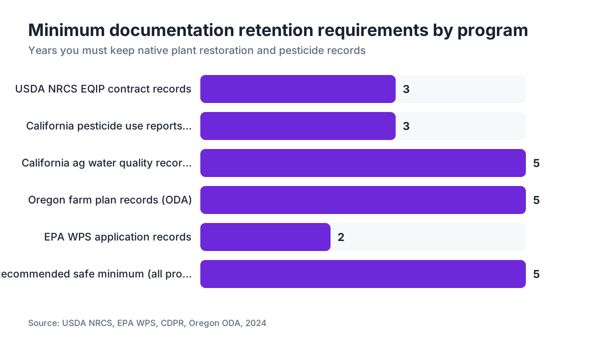
For NRCS EQIP contracts, keep all documentation at least three years after the contract end date, the federal retention rule for USDA program records. California's agricultural water quality program recommends five years for farm records. For pesticide use records, California requires three years; most other states require two. The safest rule across everything is five years from the date of the record. Digital storage with offsite backup makes that essentially free.
Can I count a vineyard cover crop as a native plant restoration area for compliance purposes?
Generally, no. Cover crops between vineyard rows don't meet the definition of native plant restoration for NRCS practice standards, state water board buffer requirements, or most conservation grant programs. The distinctions are species composition (native perennial species vs. introduced annual seed mixes) and location (a defined buffer area separate from cropped rows vs. in-row cover). Some habitat corridor programs count diverse cover crops toward pollinator habitat, but that's separate from native plant restoration documentation.
Sources
- California State Water Resources Control Board: California's Agricultural Order requires Tier 2 and Tier 3 irrigated agricultural operations to document vegetated buffer condition in annual reports; CDFW administers Streambed Alteration Agreements with work-window and monitoring conditions.
- EPA, Agricultural Worker Protection Standard: The EPA WPS requires that pesticide application records include product name, EPA registration number, location, date, time, amount applied, and applicator name.
- University of California Agriculture and Natural Resources (UC Cooperative Extension): UC Cooperative Extension publishes field monitoring workbooks for riparian restoration projects in California, including line-point intercept methodology and sample data sheets adaptable for vineyard-adjacent restoration.
- California Department of Pesticide Regulation: CDPR requires reporting of all pesticide applications by county and site, and guidance specifies applicators must read labels and consider wind speed and direction before each application.
- Washington State University Extension: WSU Extension publishes drift management guidance for Washington vineyards including nozzle selection, application timing, and minimum wind speed thresholds for applications adjacent to non-target vegetation; also provides VSP monitoring templates.
- Cornell University College of Agriculture and Life Sciences, Viticulture and Enology: Cornell's viticulture and enology program provides pesticide application guidance and monitoring templates for northeastern vineyard operations.
- Oregon Department of Agriculture, Agricultural Water Quality Management Program: Oregon's Agricultural Water Quality Management Act local area plans specify minimum vegetated buffer widths of 20 to 50 feet along streams depending on stream type and adjacent land slope.
- EPA, Federal Insecticide, Fungicide, and Rodenticide Act: Under FIFRA, every pesticide label is a federal legal document; label buffer requirements near sensitive habitat are enforceable regardless of whether a measurable adverse outcome occurs.
- California Department of Fish and Wildlife, California Natural Diversity Database: The CDFW California Natural Diversity Database maps documented occurrences of rare, threatened, and endangered plant and animal species by location and can be queried by parcel or county.
Last updated 2026-07-11