Riparian buffer documentation for vineyard operations near waterways
TL;DR
- Vineyards operating within 50 to 300 feet of streams, rivers, or wetlands must document buffer zone boundaries, pesticide application setbacks, and any disturbance activities to satisfy Clean Water Act, state water quality, and pesticide use permits.
- Required records typically include GPS-mapped buffer edges, spray records with setback distances, and site-specific BMPs.
- Gaps in documentation are the most common compliance failure during agency inspections.
What is a riparian buffer and why does it matter for vineyard compliance?
A riparian buffer is the strip of vegetation, soil, and land between your vines and a nearby stream, river, pond, or wetland. Its job is to catch sediment, filter nutrients and pesticides from runoff, and hold the bank in place. For compliance purposes, it's also the line that decides which rules apply to your spraying, tillage, and planting.
Federal jurisdiction enters under the Clean Water Act. Section 402 covers the National Pollutant Discharge Elimination System (NPDES), and Section 404 governs fill and discharge into waters of the United States [1]. State programs stack on top. California, Oregon, Washington, New York, and most other wine-producing states have their own water quality rules that set specific buffer widths and activity restrictions going further than federal minimums.
Here's the practical consequence. If you spray a pesticide, apply fertilizer, run a tractor, or install a trellis post inside a regulated buffer without documenting it correctly, you can face stop-work orders, fines, or loss of your pesticide applicator license. The buffer doesn't disappear just because grapes are growing there.
Small operations often assume they're exempt. They're usually not. The EPA's NPDES general permit for agricultural stormwater does exclude most routine field activities, but pesticide applications to or near waterways fall under a separate permitting pathway, and state riparian protection statutes commonly apply to every agricultural operation regardless of size [2].
Which federal and state regulations apply to riparian areas in vineyards?
Three federal sources set the baseline. The Clean Water Act Sections 402 and 404 establish the floor for water protection. The Federal Insecticide, Fungicide, and Rodenticide Act (FIFRA) gives EPA authority over pesticide labels, which are legally enforceable and often carry specific buffer language for aquatic environments [3]. The EPA Worker Protection Standard (WPS) is separate from water protection but overlaps when restricted-entry intervals or handler buffer restrictions affect crews working near water [4].
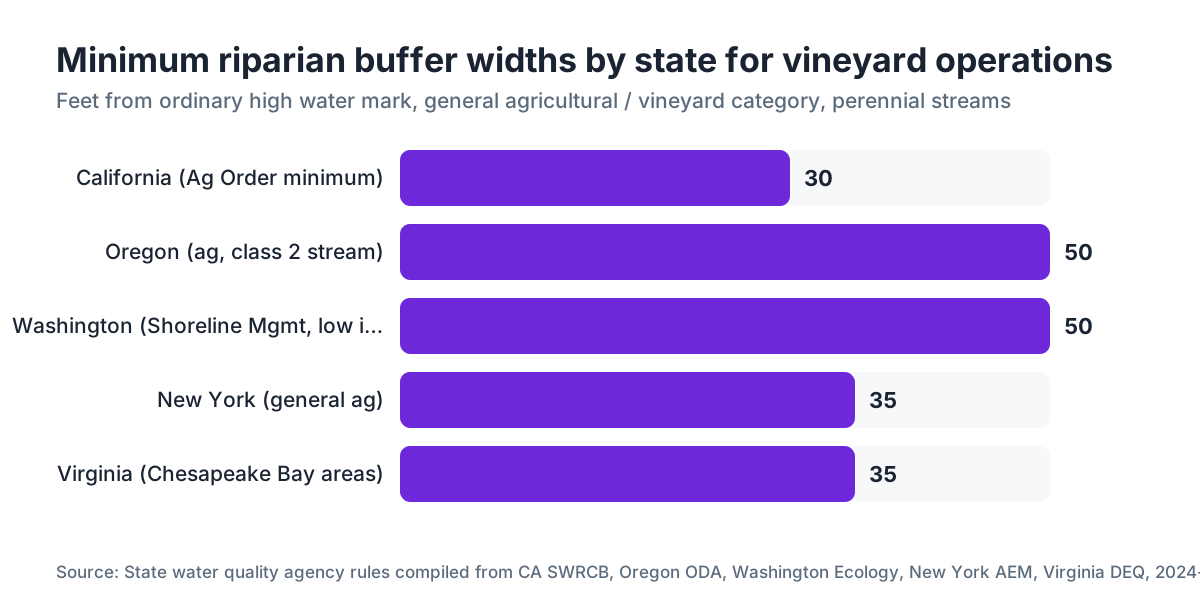
State programs vary enormously. Here's a practical comparison of buffer-width requirements and documentation rules across major wine states:
| State | Minimum buffer width (stream) | Key rule / program | Documentation required |
|---|---|---|---|
| California | 30 ft (basic); up to 200 ft for some tributaries | Porter-Cologne Water Quality Control Act; Ag Order (CVRWQCB) | Farm Water Quality Management Plan, annual compliance report |
| Oregon | 50 ft (timber); 10-50 ft ag depending on stream class | Oregon Forest Practices Act (timber); ODA Water Quality Program for ag | Field-by-field map, pesticide records with setback notation |
| Washington | 25-200 ft depending on stream type | Shoreline Management Act; WSDA water quality | Buffer maps, spray records, BMP documentation |
| New York | 35 ft (general); 100 ft riparian buffer incentive | Ag Environmental Management (AEM) program | AEM Tier II or III assessment on file |
| Virginia | 35 ft mandatory (Chesapeake Bay Preservation Act for CBPA areas) | Chesapeake Bay Preservation Act | Site plan showing vegetated buffer |
Widths in the table are minimums from primary state rules as of 2024-2025. Your county or water board may add requirements. Always verify with your local agency.
In California, the Central Valley Regional Water Quality Control Board's Conditional Waiver of Waste Discharge Requirements (the "Ag Order") is the instrument most vineyard managers actually deal with. It requires a Farm Water Quality Management Plan and annual self-certification that you're meeting buffer and irrigation water management standards [5]. Missing or outdated plans are the most cited deficiency in Central Valley ag inspections.
What specific records do you need to document a riparian buffer?
There's no universal single-page form for this. What agencies want is a file that proves, after the fact, that you knew where the buffer was and operated accordingly. That file needs several pieces.
First, a site map showing the water feature, the buffer boundary, and your vineyard blocks relative to it. GPS coordinates or a survey-quality boundary make this defensible. A hand-drawn sketch on a topo map works for low-risk situations. If you're in a 303(d) impaired watershed or your county has a riparian corridor ordinance, you want something better.
Second, pesticide application records that include the distance from the application site to the nearest water feature. FIFRA requires pesticide applicators to keep records for commercial applications, and state pesticide regulations generally extend that to private applicators [3]. If a label says "do not apply within 50 feet of any body of water," your spray record needs to show the application was outside that boundary. The label language is law. A record that just says "Block 7, Chardonnay" without noting proximity to the creek is not adequate documentation.
Third, disturbed-area records. If you graded, tilled, or installed drainage within or next to the buffer, you need dates, equipment used, acreage disturbed, and what BMPs (silt fences, straw wattles, revegetation) you applied. California's Construction General Permit, if your project disturbed more than one acre, required a Stormwater Pollution Prevention Plan (SWPPP). Smaller disturbances near waterways may still trigger local grading permits that carry their own record requirements.
Fourth, a vegetation management log if you're mowing or applying herbicides in the buffer zone itself. Many water quality programs require or strongly encourage keeping native or perennial vegetation in the buffer. If you're maintaining it differently, you need documentation of why and what alternative practice you're using.
Keep these records for at least three years. California's Ag Order requires five. Some pesticide use reports under state law must be filed with the County Agricultural Commissioner within specific timeframes, often 7 days for restricted-use pesticides [6].
How do you map and GPS your buffer boundaries correctly?
Good buffer documentation starts with an accurate base map. For most vineyard operations, that means a mix of aerial imagery (Google Earth or NAIP imagery from the USDA Farm Service Agency is free) and on-the-ground GPS waypoints at the ordinary high water mark (OHWM) of the stream or the edge of the wetland [7].
The ordinary high water mark is a legal concept, more than a physical feature. It's the line where the presence and action of water have left a mark on the shore, such as a clear change in vegetation, soil character, or a debris line. EPA and Army Corps of Engineers guidance documents describe how to identify it [1]. If there's any ambiguity, a qualified wetlands delineator or your county resource conservation district (RCD) can help mark it without a formal delineation costing thousands of dollars.
Once you have the OHWM or wetland edge, measure your required buffer width from that line, not from the water's edge during low flow. This is where many operators get it wrong. During a dry summer, a creek might look 20 feet narrower than it runs in spring, and if you set your buffer from the summer water edge, you're probably operating inside the regulated zone.
For most vineyards, a consumer-grade GPS unit accurate to 3 to 10 feet is enough for buffer mapping. Sub-meter GPS (like the Trimble Geo series) is worth it if you have tight blocks close to a buffer boundary, or if you're in a county with strict setback enforcement. Document the datum (NAD83 or WGS84), the collection date, and who collected the data.
Store your maps digitally, ideally in a format that layers your blocks, buffer zones, and application areas. This is exactly the kind of record that tools like VitiScribe are built around: keeping spatial and compliance records linked so you can pull a complete picture during an inspection.
What are the pesticide label setback requirements near water features?
Pesticide labels are federal law under FIFRA. The phrase "the label is the law" is not a metaphor. Violating a label direction is a federal violation, even if your state doesn't separately prohibit the action [3].
Many common vineyard pesticides carry specific aquatic buffer language. Mancozeb fungicides often require a 50-foot no-spray buffer from bodies of water. Sulfur-based products typically have no aquatic buffer requirement. Imidacloprid, a systemic insecticide used in some vine programs, carries a bee protection buffer plus aquatic organism language. Glyphosate formulations differ: Roundup ProMax, for example, requires specific precautions near aquatic areas that differ from agricultural glyphosate products approved for near-water use.
The thing to remember: the buffer width printed on the label applies to the pesticide as mixed and applied, more than the active ingredient alone. Surfactants and adjuvants can have their own aquatic toxicity. If you're tank-mixing, the most restrictive buffer among all products in the mix applies.
California has gone further with the Sustainable Groundwater Management Act and related surface water protections. Some County Agricultural Commissioners now require applicators to note GPS coordinates of application nearest to water features for any restricted-use pesticide applied within 100 feet of a waterway. Check with your CAC for local rules [6].
For Washington State vineyards, the WSU Extension pesticide safety program publishes practical guidance on label compliance near water, including which products are approved for over-water or near-water use under Washington's Surface Water Quality Standards [8]. Cornell's Cooperative Extension program in New York has similar materials tailored to Finger Lakes and Hudson Valley operations near tributaries [9].
What are best management practices (BMPs) for buffers and how do you document them?
BMPs are the specific practices an operation commits to in order to prevent or minimize water quality impacts. For riparian buffers, they fall into a few categories.
Vegetation management BMPs include keeping a permanent cover of grasses, perennial plants, or native vegetation in the buffer. USDA NRCS Practice Standard 393 (Filter Strip) and Practice Standard 391 (Riparian Forest Buffer) define what qualifies and how to measure it [10]. If you're establishing a filter strip as a BMP, document the species planted, seeding date, establishment method, and a photo log of vegetation coverage over the first two growing seasons.
Erosion control BMPs include cross-slope cover crops in vineyard rows that drain toward waterways, water bars or grade breaks to redirect concentrated flow, and end-of-row silt socks or check dams. Document these with photos, installation dates, and maintenance records.
Fertilizer and nutrient management BMPs for buffers mean no broadcast spreading of fertilizer inside the buffer, and any fertigation program should have backflow prevention and shut-off distances documented.
The documentation format most agencies accept is either a written farm plan (California's Ag Order uses a Farm Water Quality Management Plan template), an NRCS conservation plan (available through your local NRCS office and often funded through EQIP), or an Ag Environmental Management (AEM) workbook in New York [9]. Use these templates. They were designed by the agencies that will eventually audit you. A custom document format may cover the same ground but requires more explaining during an inspection.
Photo documentation is underrated. A dated photo of your buffer vegetation each spring and fall takes five minutes and can settle a dispute about when a practice was established or whether vegetation was present during a particular application.
What happens during a riparian buffer inspection and what do agencies look for?
Inspections come from several directions. The most common trigger for small and mid-size vineyards is a complaint, usually from a downstream neighbor, a fishing or conservation group, or a county stormwater agency following a rain event that turned a local creek muddy. Routine inspections under state Ag Orders happen on a scheduled cycle in some regions.
What an inspector typically asks for: your Farm Water Quality Management Plan or equivalent, your last two to three years of pesticide use records, your buffer map, and evidence that you've maintained or documented any disturbed areas near waterways. If you're in a CAFO permit situation (concentrated animal operations on mixed ag property), there may be extra requirements, but most pure vineyard operations aren't in that category.
Inspectors look at the buffer itself, more than your records. They'll walk the bank and look for signs of direct tillage or spray damage to riparian vegetation, erosion rills running toward the creek, tire tracks, or bare soil inside the buffer boundary. Records that say you maintained the buffer while a denuded bank tells a different story cause problems.
The most common deficiencies cited in California water board inspections of ag operations: no written Farm Water Quality Management Plan on file, pesticide records that don't include application location relative to water features, and no erosion control BMPs on slopes draining to waterways. Even a basic written plan puts you ahead of a large share of operations that get notices of violation.
Fines under California's Porter-Cologne Act can reach $10,000 per day per violation for water quality violations [13]. FIFRA civil penalties for label violations can reach $19,162 per violation for private applicators as of the EPA's 2024 penalty adjustment [3]. These numbers aren't meant to scare you. They explain why a few hours of documentation work is a reasonable investment.
How do Farm Bill conservation programs help with buffer documentation and funding?
The USDA Natural Resources Conservation Service runs two programs that matter here. The Environmental Quality Incentives Program (EQIP) pays cost-share for installing conservation practices, including riparian buffers, filter strips, and stream bank stabilization [10]. Payment rates vary by state and practice. For a 100-foot riparian buffer established under NRCS Practice Standard 391, cost-share rates in California in 2024 ran from $800 to $1,400 per acre depending on plant materials.
The Conservation Reserve Program (CRP) is less common for active vineyards because it means taking ground out of production. For marginal or flood-prone strips next to vines, it's worth a look.
Here's the point for documentation. Enrolling in NRCS programs gives you a conservation plan prepared by an agency technical specialist, which works as ready-made buffer documentation. The plan names the water feature, the buffer dimensions, the prescribed practice, and the maintenance schedule. That document was written by the agency and signed off by the agency. It's as defensible as documentation gets.
Contact your local NRCS service center to start. You can find your office through the USDA NRCS office locator [10]. The UC Davis Agricultural and Natural Resources (UC ANR) program and UC Cooperative Extension farm advisors can help California vineyard operators sort out which EQIP practices are eligible and how to prioritize them [11].
What do UC Davis, Cornell, and WSU extension programs say about riparian buffer management?
University extension programs are the most practical source of region-specific guidance, and they publish most of it for free.
UC Cooperative Extension and UC Davis have published widely on vineyard water quality under the UC ANR program. Their "Water Quality Manual for the Wine Grape Industry" covers buffer design, pesticide setbacks, and farm planning in detail [11]. The UC ANR Statewide Integrated Pest Management Program also publishes pesticide-specific guidance on water quality restrictions. Bookmark these and cite them in your farm plan, because they represent the current consensus of the state's leading vine researchers.
Cornell Cooperative Extension has strong materials for New York vineyards, particularly around the Finger Lakes tributaries to Seneca and Cayuga Lakes, which have Total Maximum Daily Load (TMDL) restrictions. Cornell's Viticulture and Enology program at the College of Agriculture and Life Sciences publishes guidance on nutrient management near water and cover crop establishment for buffer zones [9].
WSU Extension publishes the Pest Management Guide for Wine Grapes in Washington, which includes water quality considerations and setback requirements for the state's major viticultural regions [8]. The Columbia Basin regions operate under state NPDES coverage, and WSU's materials help applicators understand which label conditions trigger state-specific reporting.
All three programs offer farm planning templates and, in some cases, direct technical help through county extension advisors. The help is free, and the advisor's notes from a site visit add another layer of documented good-faith compliance.
How should you organize your riparian buffer compliance file?
A compliance file doesn't need to be elaborate. It needs to be complete and findable when someone shows up at your operation unannounced.
The basic structure that works for most vineyard operations:
- Site map (current, dated, with buffer boundaries and block labels)
- Water feature identification (creek name or identifier, tributary status, whether it's on the 303(d) impaired waters list)
- Farm Water Quality Management Plan or equivalent written BMP plan
- Pesticide use records by date, block, product, rate, and setback from water (three to five years of history)
- Fertilizer and soil amendment records with application locations
- Disturbance log (any tillage, grading, or installation work near the buffer, with dates and BMPs applied)
- Vegetation monitoring photos (spring and fall)
- Copies of any NRCS conservation plans or AEM workbooks
- Any agency correspondence, inspections, or notices of violation
Keep the file in one physical binder and a digital backup. If you use field management software, a tool like VitiScribe can keep spray records, block maps, and compliance notes in one place you can pull up during a field inspection from a phone or tablet instead of a binder that's back at the office.
Review the file at the start of each season and after any significant rain event or disturbance near the buffer. A 15-minute annual review catches gaps before an inspector does.
What are the most common documentation mistakes vineyard operators make?
The number one mistake is no written plan at all. Plenty of operators manage their buffers correctly in practice but have nothing on paper showing it. An inspector can only evaluate what's documented.
Close behind is spray records that don't connect to geography. A record listing the product, rate, and date but not the block or its relationship to a water feature is incomplete for compliance. Adding a single field to your spray form, "distance to nearest waterway," fixes this and takes two seconds.
Third is buffer creep. Over time, equipment operators park in the buffer, row end-posts get pushed closer to the creek, and the effective buffer shrinks. Without a map checked against field reality each season, this happens invisibly. A GPS track of the buffer edge stored in your file and walked every two or three years catches it.
Fourth is using the summer water edge as the buffer baseline. The ordinary high water mark is typically wider and higher than the low-water summer channel. Measure your setbacks from the wrong line and you can be in violation without knowing it.
Fifth is ignoring temporary waterways. Seasonal drainage ditches, swales, and ephemeral channels that only flow after rain are often regulated the same as perennial streams for pesticide setback purposes, under both FIFRA label language and many state water quality programs. "It's dry in summer" does not make it unregulated.
Frequently asked questions
How wide does a riparian buffer need to be for a vineyard?
Minimum widths vary by state and stream type. California's Ag Order sets buffers based on slope and erosion risk, often 30 feet minimum. Oregon ranges from 10 to 50 feet for agricultural land. Washington's Shoreline Management Act sets 25 to 200 feet depending on stream classification. Always measure from the ordinary high water mark, not the summer water edge. Verify your specific requirement with your state water quality agency or county.
Do vineyard pesticide applications require setbacks from streams even if the label doesn't mention it?
Yes, in most cases. Even if a specific pesticide label has no explicit aquatic buffer language, state water quality regulations and county agricultural commissioner rules may impose their own setbacks. California, for instance, applies extra restrictions beyond labels for applications near water bodies. The FIFRA label is the floor, not the ceiling. State rules frequently require larger setbacks or prior notification.
What is a Farm Water Quality Management Plan and does my vineyard need one?
A Farm Water Quality Management Plan (FWQMP) is a written document describing how your operation manages irrigation, runoff, pesticides, and nutrients to protect water quality. In California's Central Valley, the Ag Order from the Regional Water Quality Control Board requires most irrigated agricultural operations, including vineyards, to have one on file and certify compliance annually. Other states have equivalent programs under different names.
How long do I need to keep riparian buffer and pesticide records?
California's Ag Order requires five years. Federal FIFRA regulations require private applicators to keep records of restricted-use pesticide applications for two years, and commercial applicators for two years as well. California pesticide use reports must be filed with the County Agricultural Commissioner within seven days for restricted-use materials. Keep everything for five years to satisfy the strictest applicable requirement.
Can I apply herbicides within the riparian buffer zone?
It depends on the product label and state rules. Most standard vineyard herbicides, including many glyphosate formulations, carry explicit restrictions on use near water. Products approved for use in or near water (labeled under FIFRA for aquatic use) exist but require separate certification in some states. Mechanical management or approved ground cover programs are the most defensible practices within a buffer zone.
What triggers a riparian buffer inspection for a vineyard?
The most common triggers are downstream complaints, visible turbidity in nearby waterways after rain events, and routine compliance checks under state Ag Orders. In California, the Regional Water Quality Control Boards conduct inspections on a rolling schedule. Having an up-to-date Farm Water Quality Management Plan on file significantly reduces the risk of a notice of violation during an inspection.
Does USDA NRCS offer funding to help establish riparian buffers in vineyards?
Yes. The Environmental Quality Incentives Program (EQIP) pays cost-share for installing riparian buffers, filter strips, and stream bank stabilization practices. In California, cost-share rates for riparian buffer establishment in 2024 ranged from roughly $800 to $1,400 per acre depending on plant materials. Contact your local NRCS service center to check current rates and eligibility for your operation.
What GPS accuracy is needed for buffer boundary mapping?
Consumer-grade GPS accurate to 3 to 10 feet is adequate for most vineyard buffer documentation. Sub-meter accuracy matters if your vine rows run close to the buffer edge or if your county enforces precise setbacks. Record the GPS datum (NAD83 or WGS84), the collection date, and the collector's name in your file. Update the map if the channel moves significantly after a flood event.
Are seasonal or ephemeral streams regulated the same as perennial streams for vineyard setbacks?
Often yes. Many pesticide labels use language like "any body of water" or "surface water" that includes seasonal drainages. State water quality programs in California, Oregon, and Washington typically extend protections to ephemeral channels that flow after precipitation. The fact that a drainage is dry in summer does not exclude it from label-based or statutory setback requirements.
What is the ordinary high water mark and how do I identify it?
The ordinary high water mark (OHWM) is the line where water presence has left a physical mark on the shore, typically shown by changes in soil character, vegetation type, or a debris line. It's the legal baseline for measuring buffer widths and determining Clean Water Act jurisdiction. EPA and Army Corps of Engineers guidance documents describe identification methods. When in doubt, contact your county resource conservation district for a free site visit.
Do the EPA Worker Protection Standard rules apply inside riparian buffer areas?
The EPA Worker Protection Standard governs pesticide handler and fieldworker safety, including restricted-entry intervals and personal protective equipment. It applies to workers who enter treated areas, including areas near water features. While WPS doesn't set aquatic buffer distances directly, restricted-entry intervals may limit crew access to buffer-adjacent blocks after application, affecting your operational timing.
What photos should I be taking for riparian buffer compliance documentation?
Take dated photos of buffer vegetation at the start and end of each growing season, any erosion control BMPs you've installed, and any disturbance areas before and after remediation. Photos showing the bank, vegetation cover, and any silt or runoff controls are the fastest way to document good faith compliance. Store them in a folder labeled by date and block, linked to your written records.
How do I find out if my vineyard is in a 303(d) impaired watershed?
The EPA's ATTAINS (Assessment, Total Maximum Daily Load Tracking and Implementation System) database lets you search by watershed or water body for impaired designation. Your state water quality agency also publishes 303(d) lists. Being in an impaired watershed typically triggers stricter documentation requirements and may require participation in a TMDL program with specific load reduction commitments.
What is the difference between a riparian buffer and a filter strip?
A riparian buffer is the broader protected zone next to a waterway, covering vegetation, soil, and sometimes floodplain area. A filter strip is a specific BMP practice, defined under NRCS Practice Standard 393, consisting of uniform dense vegetation designed to slow runoff and filter sediment and chemicals. A filter strip can be part of a riparian buffer, but the two terms aren't interchangeable in regulatory or NRCS program contexts.
Sources
- U.S. EPA, Clean Water Act Sections 402 and 404 overview: Clean Water Act Section 404 governs fill and discharge into waters of the United States; Section 402 covers the NPDES program
- U.S. EPA, NPDES agricultural stormwater exemption and pesticide general permit: EPA's NPDES general permit excludes most routine agricultural stormwater activities but pesticide applications to waterways fall under a separate permitting pathway
- U.S. EPA, FIFRA pesticide labels and enforcement: FIFRA pesticide labels are legally enforceable; civil penalties for label violations can reach $19,162 per violation for private applicators as of the 2024 penalty adjustment
- U.S. EPA, Worker Protection Standard for agricultural pesticides: The EPA Worker Protection Standard regulates pesticide handler and fieldworker safety including restricted-entry intervals and PPE requirements
- California State Water Resources Control Board, Irrigated Lands Regulatory Program (Ag Order): California's Ag Order requires most irrigated agricultural operations to keep a Farm Water Quality Management Plan and self-certify compliance annually, with records retained five years
- California Department of Pesticide Regulation, pesticide use reporting requirements: California requires restricted-use pesticide use reports to be filed with the County Agricultural Commissioner within seven days of application
- USDA Farm Service Agency, NAIP aerial imagery program: NAIP aerial imagery is freely available through USDA FSA and can be used as a base map for buffer boundary documentation
- Washington State University Extension, Pest Management Guide for Wine Grapes in Washington: WSU Extension publishes pesticide application guidance including water quality setback requirements for Washington viticultural regions
- Cornell Cooperative Extension, Viticulture and Enology / Ag Environmental Management: Cornell publishes guidance on nutrient management near water and buffer establishment, and New York's AEM program provides Tier II and III workbook documentation
- University of California Agriculture and Natural Resources (UC ANR): UC ANR publishes the Water Quality Manual for the Wine Grape Industry covering buffer design, pesticide setbacks, and farm planning
- U.S. EPA, ATTAINS impaired waters database: EPA's ATTAINS database allows search by watershed or water body for 303(d) impaired waters designation
- California Porter-Cologne Water Quality Control Act, Water Code Section 13000 et seq.: Porter-Cologne Act civil penalties for water quality violations can reach $10,000 per day per violation
Last updated 2026-07-11