Setting up a vineyard block map for spray record keeping

TL;DR
- A vineyard block map assigns every row group a unique ID, acreage, and crop description so each spray record ties to a specific location.
- Most states require pesticide application records to identify the treated site by field or block.
- Getting the map right before you spray saves hours of reconstruction and protects you in an audit.
Why does a vineyard block map matter for spray records?
A spray record without a map is a list of chemicals and dates that tells nobody where the product went. That is the first thing a county agricultural commissioner or state pesticide inspector asks. Every major state pesticide record-keeping rule, including California's CCR Title 3 Section 6624 and Washington's WAC 16-228, requires application records to identify the treated site or field [1][2]. Without a map that ties your block names to real acres, you cannot answer that on paper.
There is also a worker safety angle. The EPA Worker Protection Standard (WPS) applies to any agricultural establishment using registered pesticides. It requires the location of pesticide applications to be recorded and workers to be kept out of restricted-entry intervals (REIs) in treated areas [3]. Inspectors verify compliance by matching application records to block locations. If your block names are vague or inconsistent, that match fails.
The map pays off at harvest too. When you need to check pre-harvest intervals (PHIs) across several applications on one block, an authoritative map means you pull records for Block 12 and get everything. No hunting through notes that say "the cabernet by the barn" versus "north cab block" versus "block C."
Small vineyards skip this step because it feels like paperwork. That is a mistake. It costs real time during audit season, or the day a pest control adviser asks for your spray history on a specific parcel.
What information does each block entry need to include?
Treat each block entry as the header on a form. Every spray record you create references it, so it needs enough detail to answer the five questions a regulator asks: where, how big, what crop, what timing matters, and who's responsible.
At minimum, each block entry should carry:
- Block ID: a short, unique code you will actually use consistently. Something like "EST-12" or "CAB-NW-04" works. Avoid names that need local knowledge to decode.
- Legal parcel or APN: ties the block to the property record your county has on file.
- Acreage: the treated acreage, not the total parcel acreage. Regulators care about what got sprayed.
- Crop and variety: "Vitis vinifera, Cabernet Sauvignon" is the right level of detail. Some state forms ask for the EPA site code (grapes fall in the 3500s range of the EPA commodity system) [4].
- Irrigation type: drip, overhead, flood. This matters because some labels restrict application near water systems.
- Row orientation and spacing: useful for calculating spray volume and for operators who need to verify coverage.
- Year planted or vine age: affects label language around established versus newly planted vines.
You do not need GIS precision on day one. A hand-drawn map with measured acreage gets you compliant. Accuracy beats technology.
Many managers skip a "notes" field for anything unusual about the block: a riparian buffer on the east edge, or a section replanted in 2022 on a different rootstock. Those details show up in spray records eventually. Having them in the block entry beats trying to remember them under audit.
How do you measure and assign acreage to each block?
Acreage accuracy matters because pesticide use reports (PURs) in California and similar documents in other states require the treated acreage per application, and inspectors cross-check your totals against parcel records [1]. Being off by half an acre on a five-acre block is survivable. Being off by five acres on a fifteen-acre ranch raises flags.
The common methods:
| Method | Accuracy | Cost | Good for |
|---|---|---|---|
| GPS field app (e.g., CalTopo, OnX) | ±2% on irregular shapes | Free to ~$100/yr | Most operations |
| County assessor parcel map + block subdivision | Exact to parcel boundary | Free | Rectangular blocks |
| Dedicated ag mapping software | ±1% | $500-$2,000/yr | Large or complex ranches |
| Licensed surveyor | <0.1% | $2,000-$8,000 per property | Legal disputes, subdivision |
| Row count x row length math | ±5% | Free | Quick sanity check |
For most small and mid-size vineyards, a GPS field app plus your county assessor's parcel data is accurate enough. Walk the block perimeter with your phone, record the polygon, and you have a defensible acreage figure. Washington State University's viticulture extension program publishes guidance on free GIS tools for vineyard mapping worth reading before you buy anything [5].
One honest caveat: if your vineyard has irregular shapes, knolls left out of planting, or easements, the row-count math method can be significantly off. Measure the actual planted area, not the parcel boundary.
What's the best naming system for vineyard blocks?
There is no universal standard, but some naming systems create problems and some do not.
Problems come from names that depend on memory: "the old zin block," "Tom's cab," "the steep one." Fine in conversation. Useless in a pesticide record that needs to hold up five years later, after Tom has left and the vines are a different age.
A workable scheme has three parts: a prefix that identifies the ranch or estate (important if you manage multiple properties), a variety or use code, and a sequential number. Something like EST-CS-01 for the first Cabernet Sauvignon block at a single estate. Multiple ranches? RCH1-CS-01 and RCH2-CS-01 keep them distinct.
Some operations prefer grid-based naming: blocks named by compass quadrant and sequence. NE-01, NE-02, SW-01, and so on. That works well for larger, more uniform ranches.
Whatever you pick, write it down as a legend on the master map, date it, and do not change it mid-season. Rename a block in July and your spray records from before and after refer to different labels for the same physical dirt. That is exactly the confusion you are trying to avoid.
Cornell's viticulture and IPM extension programs recommend keeping a formal block legend as a standalone document, separate from the map itself, so the naming logic stays findable [6].
How do you draw the actual map, and what format works best?
You have three real options: hand-drawn on paper, a spreadsheet with a rough sketch, or a digital map in a GIS or farm management app. Each has trade-offs.
Hand-drawn maps work. Seriously. A clear hand-drawn map on grid paper, with labeled blocks, a north arrow, a scale bar, and a legend, satisfies every state pesticide record requirement I know of. Laminate it. Keep a copy in the spray rig. University of California's viticulture extension has long recommended this for small operations because the setup cost is zero and the update cost is a pen [7].
Spreadsheet-plus-sketch is a step up. You keep the block data (ID, acreage, variety, parcel) in a spreadsheet and reference a hand-drawn or printed aerial image. The spreadsheet makes it easy to generate the "treated site" data for spray records without rewriting it each time.
Digital GIS maps are the most powerful and the most work to set up right. Tools like Google Earth (free), ArcGIS Online, or vineyard-specific platforms let you draw polygons, auto-calculate acreage, and export block data into application records. The real advantage: replant two rows, update the block once, and every future record reflects the change.
Manage more than 50 acres or more than one property, and the digital route pays for itself fast in reduced transcription errors. Under 50 acres, a clean paper map with a spreadsheet legend is genuinely fine.
VitiScribe, for example, lets you build a block map and attach it directly to your spray records, so block data auto-populates each application entry without re-keying. Purpose-built tool or spreadsheet, the principle holds: one master map, referenced by every record.
How do EPA WPS requirements connect to your block map?
The EPA Worker Protection Standard (40 CFR Part 170) requires agricultural employers to post information about pesticide applications in a central location accessible to workers and handlers [3]. That posting must include the location of each application, which means the treated field or block has to be identifiable on something workers can read.
The WPS was revised in 2015 and those revisions took effect in 2017. Under the current rule, the application-specific information posted must include the location of the treated area (described by field, block, or another designation workers can match to the actual physical location), the product name, the REI, and the end time of the REI [3].
EPA's WPS applicator training materials state that the treated area should be described "in a way that allows workers to identify where they should not enter" during the restricted-entry interval [11]. A block ID that workers recognize, on a posted map they can see, is how you meet that.
If your block names differ between your spray records and your posted central display, you have a compliance gap. Inspectors have caught exactly this during WPS audits: the spray record says "Block 4-A" but the posted notice says "east grenache." Same block, different name, different record.
One practical step: post a copy of your block map at your central location display. If an inspector sees a block name on a spray record they do not recognize, they can cross-reference it on the spot.
What state-specific rules should you know about block identification?
States vary on how specifically they require treated-site identification, and the trend runs toward more detail, not less.
California: The Department of Pesticide Regulation requires each application record to include the county, legal description or site address, and commodity [1]. DPR inspectors expect block-level identification for vineyards. The Pesticide Use Report system, which licensed pest control operators and growers must file, requires the section/township/range or a GPS point for the treated site.
Washington: WAC 16-228-1250 requires the location of the application, described as specifically as is practicable. State Department of Agriculture audits have cited vague location descriptions as violations [2].
Oregon: OAR 603-057-0400 requires the field or location of application. Oregon Department of Agriculture guidance recommends a permanent field identifier that matches your property records [8].
New York: New York State DEC Part 325 requires a description of the location treated. Cornell's extension programs recommend tax map parcel numbers combined with block names [6].
Other states: Check your state department of agriculture's pesticide record-keeping division directly. Most publish their required record fields on a public webpage. If they do not, the label itself is always the floor: labels are federal law under FIFRA Section 12, and some specify record-keeping requirements directly [10].
The safest approach is a block identifier that appears in at least two places: your spray records and your county assessor or property records. That ties operational records to the legal land description without demanding GPS precision.
How do you handle blocks that change over time?
Vineyards change. You replant a section, pull out a variety, add drip to a block that used to be dry-farmed, or subdivide a large block once you farm it differently. Your map has to handle those changes without losing the historical record.
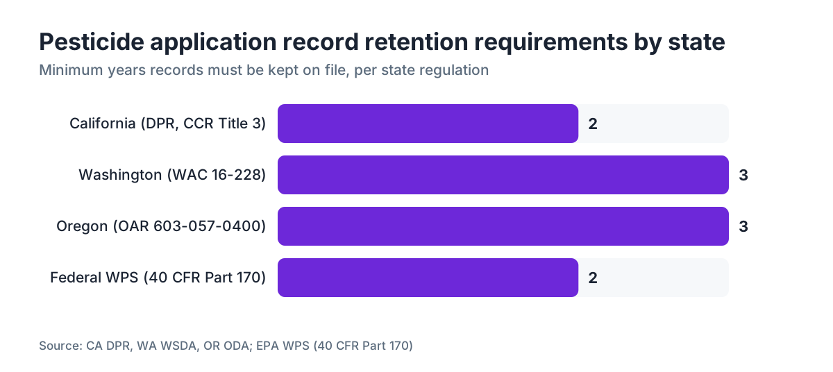
The key rule: never erase old block data, retire it. When a block changes substantially, give the new configuration a new ID (or append a version suffix like EST-CS-01v2) and note the date the old configuration was retired. Keep the old map version on file. Pesticide records typically must be kept two to three years depending on state (California requires two years for most records, Oregon requires three) [1][8]. Your map from two years ago has to stay legible and accurate for that period.
For partial replants, the most defensible move is to split the block formally. If Block 12 loses its northwest quarter to a replant in spring 2024, create Block 12A for the original vines and Block 12B for the replant. They may get different spray treatments, different PHIs once the new vines bear, and different REI postings. One block ID for both creates ambiguity that is hard to unwind later.
Digital maps make versioning easier. Most GIS tools date-stamp polygon changes. On paper, keep physical copies of the old map with a clear date label. A manila folder marked "Block map 2022-2024" costs nothing and satisfies a records inspector completely.
How does your block map connect to spray record fields?
A block map is only useful if every spray record references it consistently. Your spray record form (paper or digital) needs a field that accepts the exact block ID from your map, not a free-text description.
Here is what a well-formed spray record entry looks like when the block map is set up right:
| Record Field | Pulls from block map | Example value |
|---|---|---|
| Block ID | Yes, direct lookup | EST-CS-01 |
| Commodity / crop | Yes | Vitis vinifera, Cabernet Sauvignon |
| Treated acreage | Yes, from block entry | 4.2 acres |
| County and site location | Yes, from parcel reference | Napa County, Sec. 14 T7N R5W |
| Application date | No, entered fresh | 2024-05-15 |
| Product name and EPA reg. no. | No, from label | Quintec, EPA Reg. No. 264-828 |
| Application rate and volume | No, calculated from acreage | 4 fl oz/acre, 16.8 fl oz total |
| REI end date/time | No, calculated from label | 2024-05-16 12:00 PM |
| Applicator name and license no. | No, entered or pre-filled | Jane Smith, CA QAL 12345 |
When the first four rows come straight from your block map, the transcription error rate on those fields drops to near zero. Acreage errors on pesticide use reports are one of the most common audit findings in California, and they almost always trace back to someone re-entering acreage from memory instead of from a master record [1].
Managing multiple blocks in a single application? The record needs a separate line or sub-entry for each block. Lumping two blocks onto one line because they got the same treatment is convenient and wrong. Block-level records are what let you reconstruct the REI boundary for any single physical location.
What are the most common mistakes in vineyard block map setup?
These patterns show up repeatedly in audit findings and in conversations among vineyard managers.
Using the same name two ways. Block names that mean one thing to the spray crew and another in the records. The crew calls it the "home block," the records say "Block 1," the map says "A-1." Pick one and enforce it.
Acreage that doesn't match parcel records. If your parcel is 10.4 acres but your spray records show 12 acres treated in a season, someone will ask why. Calculate treated acreage carefully and reconcile it against assessor data once.
No map on file, just memorized block names. Common in operations where the same person has run the vineyard for twenty years. It is not a compliance strategy. It is institutional knowledge that vanishes when that person retires or is out sick during an audit.
Maps that are not dated. A map without a date is ambiguous. When did this configuration apply? Put the creation date and any revision dates directly on the map.
Blocks that span property lines. Farm a block that crosses APN boundaries and each portion needs to be recorded separately for pesticide use reporting in most states. A block sitting on two parcels is two treated sites for reporting, even if you treat it in one pass.
REI boundaries that don't match block boundaries. If your REI posting says "east side of estate" but your spray records use numbered blocks, workers cannot map one to the other. The block map and the WPS central display need to speak the same language.
Can a simple spreadsheet work, or do you need dedicated software?
For a vineyard under 20 acres with a single operator and a straightforward block structure, a well-organized spreadsheet and a printed paper map satisfy every regulatory requirement I know of. The state does not care what software you used. It cares that records are accurate, complete, retained for the required period, and available for inspection.
A spreadsheet block registry with columns for Block ID, Variety, Acreage, APN, Year Planted, Irrigation Type, and Notes, paired with a dated aerial or hand-drawn map, is a solid foundation. Add a consistent spray record form that references the block IDs from that spreadsheet, and you have a compliant system.
Where spreadsheets break down: multi-user operations, multiple properties, and complex spray programs with many products and many blocks per season. When three people enter spray records and the master block list lives on one person's laptop, you get version drift. You also get the risk of a block renamed casually in one record while nobody updates the master.
Purpose-built tools like VitiScribe earn their keep at that complexity threshold, because they enforce the block ID as a controlled vocabulary item rather than a free-text field, and they generate the formatted pesticide use reports California and Washington require. Whether that is worth the cost depends entirely on your operation's size and record volume.
The honest answer: no software makes a bad block map good. Get the map right first, then automate around it.
For operations just getting started, University of California's viticulture extension publishes a free vineyard record-keeping workbook that includes block map templates [7]. It is a sensible starting point before you spend a dollar on anything.
How do you create a block map that works for both spray records and harvest records?
The spray record and the harvest record use the same physical block, so they need the same block ID. Sounds obvious, but vineyards often build spray records and harvest records independently, with naming conventions that never quite line up.
The simplest fix: build one master block list and reference it in both workflows. If a winery manages your harvest records, share the block ID list with the winery's vineyard intake forms at the start of every season. Many wineries require their own block codes for receiving logs. If that is the case, add a column to your master block list showing both your internal block ID and the winery's receiving code. Two codes for the same block, documented in one place, is fine. Two inconsistent names with no documented link is not.
Pre-harvest interval tracking is where the two systems have to talk directly. You need the last application date and PHI for every product applied to a block before you can certify the fruit ready for harvest. If your spray records are keyed to Block EST-CS-01 but your harvest planning sheet calls it "Block 12," you have a reconciliation step every harvest that exists only because of a naming mismatch.
California's organic regulations and several certification bodies (CCOF, for example) require organic growers to keep records linking spray history to harvest blocks specifically. So the connection between spray and harvest records is more than convenient. It can be a certification requirement [9].
Large properties like Ponte Winery and South Coast Winery run block-level record management across hundreds of acres and many varieties, and the same one-master-map principle scales to that size.
Frequently asked questions
How many acres can I group into a single vineyard block for spray records?
There is no federal maximum block size for spray record purposes. Practically, split blocks when they receive different treatments, have different varieties, or are separated by a physical boundary. Most regulatory guidance treats a block as a distinct management unit. A 40-acre block that always gets the same program is one block. A 10-acre parcel split between two varieties on different fungicide programs should be two blocks.
Do I need GPS coordinates on my block map to be compliant?
GPS coordinates are not required by any state pesticide record-keeping regulation I am aware of, though California's Pesticide Use Report system accepts GPS points as an alternative to section-township-range legal description. A clear location description tied to a parcel number or legal description is enough. GPS adds precision and makes digital mapping easier, but a hand-drawn map with a legal description and acreage meets the requirement.
What happens if my spray records don't match my block map during an inspection?
The inspector asks you to reconcile them on the spot. If you cannot, it is typically recorded as an incomplete or inaccurate record, which is a violation under most state pesticide regulations. California's DPR can issue civil penalties for inaccurate pesticide use reports; fines start at a few hundred dollars and can reach $5,000 or more per violation for repeat or willful non-compliance. Keeping your block map current is much cheaper.
How long do I need to keep vineyard spray records and the associated block map?
California requires pesticide application records to be retained for two years from the date of application [1]. Washington requires three years [2]. Oregon requires three years [8]. Federal WPS record requirements run two years for most documentation. Keep your block map at least as long as your oldest spray records that reference it, because the map is the key to reading those records during an audit.
Can a single block map cover multiple ranches or vineyards I manage?
Yes, but each property should have its own map section or file, because pesticide records are site-specific and county agricultural commissioners file records by property. Use a property prefix in your block IDs (RCH1 vs RCH2, for example) so records from different ranches never mix. If you manage properties in different counties, you will typically file separate pesticide use reports by county anyway.
What block map information do I need for organic certification?
Organic certification bodies like CCOF and Oregon Tilth require field maps showing each block's location, acreage, variety, and any buffer zones adjacent to non-organic land. They also require your spray records to tie directly to those mapped blocks so auditors can verify no prohibited materials were applied. The map must be current and match your Organic System Plan. A spray record referencing a block not on your OSP field map creates a certification gap.
How do I document a block that was partially treated, not the whole block?
Record the actual treated acreage, not the full block acreage. If Block EST-CS-01 is 4.2 acres and you treated only 2.0 acres (say you stopped early for wind), the record shows 2.0 acres treated with a note explaining the partial treatment. If partial treatments happen regularly because the block has a standing-water area or buffer zone, consider formally splitting the block so the treatable portion has its own acreage entry.
Should vineyard row numbers be on the block map?
They are not required, but they are useful. Row numbers on the block map, or at least row count per block, let you calculate spray volume more precisely and help applicators identify the exact area for REI postings. If a block has an untreated buffer row along a property line, noting the row numbers makes that exclusion explicit and defensible. It also helps scouting records tie pest observations to specific rows.
Can I use Google Maps or Google Earth to build my vineyard block map?
Yes, and many small operations do. Google Earth Pro (free since 2015) lets you draw polygons over satellite imagery, label them, and export the polygon area as acreage. The result is accurate enough for spray records in most states. Save a dated PDF or KMZ export of your block polygons as your official map file. The main limitation is that Google's imagery may lag recent changes, so verify the imagery shows your current block layout before relying on it.
What is an EPA site code and do I need it on my block map?
EPA site codes are identifiers in the EPA's pesticide registration system describing the crop or site where a pesticide is applied. For grapes, the relevant site codes fall in the 3500s range. Some states require or accept EPA site codes on pesticide use reports. They belong on your spray records rather than the block map itself, but noting the EPA site code in your block legend is a useful cross-reference when filling out state use reports.
How often should I update my vineyard block map?
Update it whenever a block changes: replanting, new irrigation, a variety change, a boundary adjustment. At minimum, review and date-certify your block map at the start of each growing season before the first spray application. A map accurate for 2023 but never reviewed for 2024 creates record errors if a replant or boundary change happened over winter. A seasonal review takes fifteen minutes and eliminates a category of audit risk entirely.
Do I need a separate block map entry for cover crops or other non-grape crops in the vineyard?
If you apply registered pesticides to cover crops (including herbicides between rows), those applications need records too, and the treated site description should reflect what was actually treated. Spray a contact herbicide in the drive row of a block and the record should note the commodity is the cover crop or bare ground, not the grape vines. Your block map entry can note whether the block has a treated drive row so the applicator records it correctly.
What should I do if I bought a vineyard that has no existing block map?
Start fresh rather than reconstructing the previous owner's system, unless you also have their spray records and can match their block names. Walk the vineyard, number every distinct management unit, measure or GPS-trace each one, and build the map from the ground up. Check with your county agricultural commissioner about any pesticide use reports filed for the parcel in the past two years; those records may contain the previous block names, which you can cross-reference against the vine history.
Sources
- California Department of Pesticide Regulation, Pesticide Use Reporting program: California requires pesticide application records to include county, legal description or site address, and commodity; records must be retained for two years
- Washington State Department of Agriculture, Pesticide Licensing and Recordkeeping (WAC 16-228): WAC 16-228-1250 requires that application records include the location described as specifically as is practicable; records retained three years
- U.S. EPA, Agricultural Worker Protection Standard (40 CFR Part 170): WPS requires agricultural employers to post treated area location, product name, REI, and REI end time in a central location accessible to workers; the location must allow workers to identify where entry is restricted
- U.S. EPA, Pesticide Registration: EPA site codes exist for crop-specific pesticide registration; grapes are covered under site codes in the 3500s range of the EPA commodity grouping system
- Washington State University Extension, Viticulture and Enology program: WSU Extension has published guidance on using free GIS tools for vineyard mapping and site-specific management
- Cornell University College of Agriculture and Life Sciences, viticulture and IPM extension programs: Cornell extension programs recommend keeping a formal block legend as a standalone document and using tax map parcel numbers combined with block names for location records
- University of California Agriculture and Natural Resources, viticulture extension: UC Cooperative Extension recommends hand-drawn maps for small operations and publishes free vineyard record-keeping workbook templates including block map formats
- Oregon Department of Agriculture, Pesticides program (OAR 603-057-0400): Oregon requires pesticide application records to include the field or location of application and to be retained for three years
- CCOF Certification Services, Organic System Plan requirements: CCOF requires organic growers to maintain field maps showing each block's location and acreage and to link spray records to mapped blocks to verify no prohibited materials were applied
- U.S. EPA, Federal Insecticide, Fungicide, and Rodenticide Act (FIFRA): FIFRA Section 12 makes pesticide label requirements federal law; some labels specify record-keeping requirements that serve as a minimum floor regardless of state rules
- U.S. EPA, Worker Protection Standard applicator training and worker safety resources: EPA WPS guidance states that the location of the treated area should be described in a way that allows workers to identify where they should not enter during the restricted entry interval
Last updated 2026-07-11