Sonoma County stream setback requirements and how to document compliance
TL;DR
- Sonoma County stream setbacks for vineyards run through three overlapping frameworks: the county's Riparian Corridor and Setback Policy, the state Department of Fish and Wildlife's Streambed Alteration Agreement process, and the Regional Water Board's VESCO ordinance.
- Minimum buffers start at 50 feet on small intermittent streams and hit 200 feet on the Russian River main stem.
- Document compliance with dated site maps, permits, and annual inspection logs.
What stream setback rules actually apply to Sonoma County vineyards?
Three regulatory layers apply, and they stack on the same stretch of creek. Figure out which agency controls which piece before you move any dirt, plant a new block, or run irrigation near water.
The Sonoma County Riparian Corridor and Setback Policy sets a minimum 50-foot setback from the top of the bank (or the edge of riparian vegetation, whichever is greater) for most land use, vineyard development included. That 50-foot floor grows based on stream order and whether the stream holds salmonids [1].
Layer two is the California Department of Fish and Wildlife (CDFW). Under Fish and Game Code Section 1602, any project that may substantially divert, obstruct, or change the natural flow or bed of a stream needs a Streambed Alteration Agreement before work starts [2]. This is the permit people skip most often, and it generates more enforcement problems in Sonoma wine country than anything else on this list.
Layer three is the North Coast Regional Water Quality Control Board's Vineyard Erosion and Sediment Control (VESCO) Ordinance, adopted under the Porter-Cologne Water Quality Control Act. VESCO covers all new vineyard development and any conversion of non-irrigated land to irrigated vineyard within named watersheds, including parts of the Russian River basin [3]. The VESCO permit makes you prove your buffer widths meet or beat the protective standards before you grade or plant.
If your land touches a wetland or waters of the United States, add a Section 404 permit from the Army Corps of Engineers and a Section 401 water quality certification from the Regional Water Board. Most Sonoma vineyard sites in the Russian River, Dry Creek, and Alexander Valley appellations trigger at least two of these four frameworks.
What is the minimum buffer width required in Sonoma County?
The floor is 50 feet. That number almost never describes the real setback for a working vineyard next to a salmonid stream, so don't plan around it.
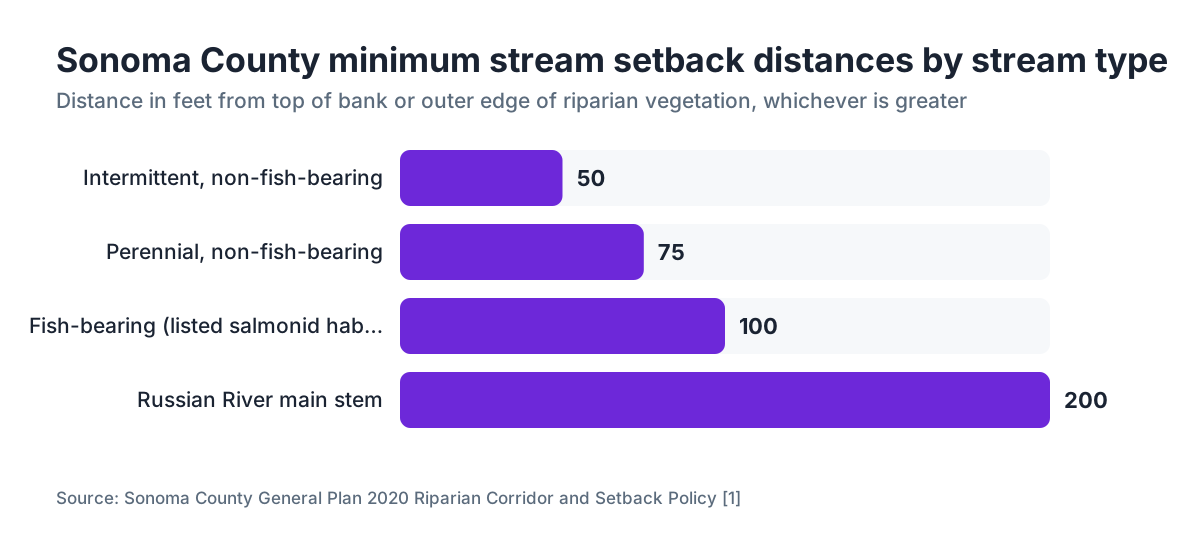
The Sonoma County General Plan 2020 and its Riparian Corridor and Setback Policy set this structure [1]:
| Stream Type | Minimum Setback from Top of Bank |
|---|---|
| Intermittent, non-fish-bearing (small) | 50 ft |
| Perennial, non-fish-bearing | 75 ft |
| Fish-bearing streams (listed salmonid habitat) | 100 ft |
| Major rivers (Russian River main stem) | 200 ft |
These are floors, not targets. CDFW Streambed Alteration Agreements routinely push buffers wider based on site-specific biological assessments, especially where coho salmon or steelhead show up [2]. Sonoma County also runs a Biotic Resources Overlay that adds another review layer in sensitive areas.
VESCO references the California Department of Food and Agriculture standard of a minimum 50-foot undisturbed vegetated buffer along all watercourses for new vineyard development, but the Vineyard Watershed Quality Control Plan for any given site can require more [3].
Here's the part that trips people up. The setback is measured from the top of bank or the outer edge of riparian vegetation, whichever sits farther from the channel. On a creek with 30 feet of willows growing back from the water, your 50-foot setback starts at the outer willow dripline, not at the bank. That's an 80-foot exclusion in real terms, and people misread it constantly.
How does California Fish and Game Code Section 1602 affect vineyard operations?
Section 1602 requires a Streambed Alteration Agreement (SAA) from CDFW for any project that "will substantially divert or obstruct the natural flow, or substantially change or use any material from the bed, channel, or bank of, any river, stream, or lake." That's the statutory language, and CDFW reads "substantially change" broadly [2].
For vineyards, it captures road crossings and culverts, bank re-contouring, removal of riparian vegetation in or beside the channel, water diversions and pump stations, and sometimes herbicide use near the channel edge. CDFW can require an SAA even for activity outside the ordinary high-water mark if there's a reasonable expectation of indirect impact.
You start with a Notification of Lake or Streambed Alteration. Submit project plans, site maps, and a biological assessment if CDFW asks for one. CDFW has 60 days to issue an agreement, request more information, or tell you no agreement is needed [2]. Do not start work during that window.
Agreements come loaded with conditions: work windows (usually outside the wet season, October 15 through April 15 across most of Sonoma County), erosion control requirements, vegetation restoration standards, and post-project monitoring. Violating an SAA is a misdemeanor and can trigger a stop-work order.
The SAA is the most time-sensitive permit you'll deal with. CDFW's review clock plus the seasonal work window means a late filing can cost you a full year. File in early spring if you want fall earthwork.
What does the VESCO ordinance require for vineyard compliance?
VESCO is the North Coast Regional Water Quality Control Board's Vineyard Erosion and Sediment Control Ordinance (Resolution R1-2000-0086 and later amendments). It applies to new vineyard development and conversion to irrigated viticulture in the Russian River watershed and several adjacent drainages inside the Board's jurisdiction [3].
If your project triggers VESCO, you file a Vineyard Watershed Quality Control Plan (VWQCP) before any grading or planting. The plan documents:
- Existing site conditions (soils, slopes, existing vegetation, drainage features)
- Proposed buffer widths with justification
- Erosion control best management practices (BMPs)
- An implementation schedule tied to the farming calendar
- A long-term operations and maintenance program
Buffer requirements in the VWQCP have to line up with the North Coast Basin Plan's narrative water quality objectives, and in practice they match or beat the county setbacks in the table above [3]. The Board may also require a Section 401 water quality certification if federal permits are in play.
Once it's approved, you're bound by the VWQCP for the life of the vineyard. Annual self-monitoring reports, usually due March 1, document whether buffers stayed intact, whether erosion controls held, and whether any spills or discharges happened. Blow the reporting deadline and you're in violation even if nothing on the ground moved.
Which watersheds and appellations are most likely to trigger multiple permits?
The watersheds that stack the most requirements are the ones with documented salmonid populations and heavy vineyard conversion history. In Sonoma County that's the Russian River main stem and its big tributaries: Dry Creek, Warm Springs Creek, Maacama Creek, Mark West Creek, and parts of the Laguna de Santa Rosa system [1].
Alexander Valley AVA and Dry Creek Valley AVA sit almost entirely inside VESCO territory and hold real coho salmon and steelhead habitat. Projects there almost always need a VWQCP, a Section 1602 SAA if work goes near any waterway, and county setback compliance. Russian River Valley AVA has the densest tangle of Laguna de Santa Rosa wetland interactions, which can pull in Army Corps Section 404 requirements.
Work in the Sonoma Coast AVA on small upland streams that are intermittent and non-fish-bearing, and your load is lighter. The county 50-foot setback applies, a Section 1602 agreement may not be needed if there's no substantial change to flow or channel, and VESCO may not apply depending on the exact watershed line. But "may not" is not "does not." That call comes from each agency, not from your own read of the maps.
Use the Sonoma County Permit and Resource Management Department (PRMD) pre-application conference. It takes a few weeks, and it maps your project against every applicable overlay before you spend money on consultants or plans.
How do you build a stream setback compliance documentation file?
Setback compliance isn't a single form. It's a file you build over time and hand to an inspector without scrambling. Here's what goes in it.
First, a dated site map at a usable scale (1:2,400 or better) showing every waterway on and next to the parcel, the delineated top of bank or riparian edge, and measured setback distances from vineyard features to those lines. Put a north arrow, scale bar, date, and preparer name on it. A licensed surveyor or qualified biologist should prepare or certify the map if permits are involved.
Second, copies of every permit and agreement: county grading permit, any CDFW Streambed Alteration Agreement, the approved VWQCP if VESCO applies, Section 404 permits, and Section 401 certifications. Keep original signed copies. Track expiration and renewal dates on a calendar.
Third, annual inspection logs. Walk the buffer at least once a year, twice is better (once after the wet season and once mid-summer). Photograph conditions, note any erosion, encroachment, or vegetation loss, and record the corrective action you took. Date every entry. Sign it.
Fourth, agency correspondence. If you called CDFW to ask whether your project needs an SAA and they said no, follow up with an email summarizing the call. That email thread is your documentation.
Tools like VitiScribe store dated inspection records, attach photos, and timestamp compliance entries so your buffer logs hold up in an audit without manual file wrangling.
Fifth, erosion control BMP maintenance records: dates you inspected inlet protection, re-seeded disturbed ground, cleaned sediment basins, or fixed road drainage. These feed straight into your VWQCP annual self-monitoring report.
What do annual self-monitoring reports for VESCO need to include?
Operate under a VESCO-approved VWQCP and you file an annual self-monitoring report with the North Coast Regional Water Quality Control Board. Reports are usually due March 1 for the preceding water year (October 1 through September 30). The Board hands you a standard form, but knowing what's in it lets you collect the right information all year instead of reconstructing it from memory in February.
The report wants a summary of vineyard activities that could affect water quality, proof that buffer zones stayed intact and at specified widths, a record of any discharges or unauthorized releases (even small sediment events in a stream), a log of BMP installation and maintenance, a statement on any modifications to the approved plan, and photo documentation of site conditions [3].
Had a violation or non-compliance event during the year? The report is where you disclose it and describe the fix. Voluntary disclosure with a credible corrective action plan lands very differently than a violation an inspector finds. The Board has enforcement discretion, and its inspectors notice whether operators are engaged and organized.
Miss March 1 and you technically fall out of compliance with your VWQCP, which can bleed into your county grading permit conditions. Set a hard February 1 internal deadline so you have a month to chase down missing paperwork.
What happens if you're found to have violated a stream setback requirement?
Enforcement climbs in steps, and the outcome depends on which agency is acting.
For county violations (planting or grading inside the required riparian setback), PRMD can issue a Notice of Violation, order restoration of disturbed areas and replanting of riparian vegetation, and put a hold on your future permits. Unpermitted grading within a riparian setback can run fines up to $10,000 per day under California Government Code Section 53069.4, though small operators usually see negotiated compliance orders rather than maximum penalties on a first offense [12].
For CDFW, operating without a required Streambed Alteration Agreement or breaking an existing agreement's conditions is a misdemeanor under Fish and Game Code Section 1615 [9]. CDFW also has civil penalty authority and can order restoration at your expense, which often costs more than any fine.
The Regional Water Board works under Porter-Cologne and can issue Cleanup and Abatement Orders, Cease and Desist Orders, and civil penalties up to $10,000 per day per violation for VESCO non-compliance [8]. In practice, the Board saves these tools for repeat violators or serious discharges. A first-time administrative slip, like a late self-monitoring report, usually gets a compliance schedule.
Here's the practical lesson. An unpermitted road crossing over a fish-bearing stream in Dry Creek Valley pulls in all three agencies at once. Restoration costs, consultant fees, and penalties in documented Sonoma County enforcement cases have run well into six figures. The permits are not optional overhead.
How do setback requirements interact with pesticide and spray record-keeping near waterways?
Spray records and setback compliance meet in two places, and vineyard managers need to track them together.
First, the Sonoma County Agricultural Commissioner requires pesticide application records that include the application site, crop, target pest, product, rate, and equipment. For blocks next to riparian setbacks, those records have to be specific enough to show that restricted materials never landed inside buffer zones set by the permit or the label [4]. If a CDFW agreement or a VWQCP includes a no-spray buffer along the creek, your spray records should explicitly document that buffer, beyond the field-level application detail.
Second, the EPA Worker Protection Standard (WPS) requires that workers in treated areas are kept safe from pesticide exposure [5]. That's not a setback rule directly. But if you have crews doing buffer maintenance (hand-weeding, mowing, vegetation checks), their proximity to recently sprayed blocks falls under WPS re-entry intervals. Make your buffer inspection logs note when adjacent blocks were last treated.
County Agricultural Commissioner offices maintain grower spray records under the California Department of Pesticide Regulation. Sonoma County's office has published guidance on pesticide buffers for restricted materials near waterways [4]. Copper-based fungicides, common in organic vineyards, carry their own label language about waterway buffers that you respect and document separately from the general stream setback.
For how to organize field spray records alongside your compliance file, the vineyard operations framework covers the structure.
What role do biotic resource assessments and biological surveys play?
For most Sonoma County vineyard projects near water, a biological assessment isn't optional. It's the document agencies use to decide which rules actually apply to you.
A qualified biologist surveys the site for sensitive species, classifies the stream type and order, maps the extent of riparian vegetation, and marks ordinary high-water marks. That report becomes the basis for CDFW's call on whether an SAA is required and what conditions ride with it. It also drives the VWQCP's erosion control prescriptions.
For properties with possible coho or steelhead habitat, CDFW may want a full salmonid habitat assessment. In some cases the Regional Water Board requires a wetland delineation by a qualified wetland scientist before it approves a VWQCP. If the project is large enough to trigger CEQA review (the California Environmental Quality Act), the biological assessment folds into the initial study or environmental impact report.
Treat the biological assessment as the thing that sets your setback distances in concrete. If the biologist calls the creek non-fish-bearing and intermittent, you may be looking at 50 feet. If they find coho rearing habitat, you're at 100 feet minimum, probably more. Get it done before you stake the vineyard layout, and you design around the setbacks instead of paying to redesign later.
UC Cooperative Extension has published guidance for growers working through biological assessments and permits for new vineyard projects [11]. Their farm advisors can point you to biologists with a real track record in the county.
How do you handle existing vineyards that predate current setback requirements?
Blocks planted before current setback rules took effect sit in a gray zone that plenty of Sonoma County operators work around every season.
Legally established prior-existing vineyards generally hold a vested right to keep operating. That protection does not stretch to expanding a non-conforming use or adding infrastructure. Replanting an existing block within the setback after you pull old vines is usually fine (same footprint, same use). Converting that block to a different variety or changing the trellis in a way that needs significant soil disturbance can trigger fresh permit review, depending on how the county planner reads it.
The riskiest moves on a pre-existing block: trenching new drip irrigation near the bank, adding a permanent road or vehicle access inside the setback, grading to improve drainage, or clearing riparian vegetation that grew up since the vineyard went in. Any of these can get treated as new activity under current rules.
Get a pre-application meeting with PRMD before you do anything structural in or near a pre-existing non-conforming block. They won't penalize you for asking, and their written response becomes part of your compliance file.
Document the history of pre-existing blocks hard. Historical aerial photos (USGS Earth Explorer carries imagery going back decades for many California locations [7]), old grading permits, and photos in farm files all back the argument that a block predates current requirements.
Where do you get current permit applications and which agency do you contact first?
Start with Sonoma County PRMD. Their Planning Division handles Riparian Corridor and Setback Policy review and can tell you whether an SAA, CEQA review, or other approvals apply based on your project description. Their online portal and pre-application conference request forms live on the county's permit site [1].
For the CDFW Section 1602 process, submit the Notification of Lake or Streambed Alteration through CDFW's online EPIMS portal [2]. Have your site map, project description, and biological assessment ready before you start.
For VESCO, contact the North Coast Regional Water Quality Control Board directly. Their Santa Rosa office handles Russian River watershed permits. The Board publishes the VESCO ordinance text, the VWQCP template, and the annual self-monitoring report form through the State Water Resources Control Board [3].
For Section 404/401, the Army Corps Sacramento District handles Section 404 for Sonoma County [10]. Their Regulatory Division processes nationwide permits for smaller impacts and individual permits for larger ones. Section 401 certification comes from the Regional Water Board as part of the same process.
One piece of honest advice. Hire a water resources consultant or environmental permitting professional with recent Sonoma County experience. The agencies know the local consultants, timelines move faster when submissions are complete, and you skip the first-timer learning curve. Consultant fees for a typical vineyard project run roughly $8,000 to $25,000 depending on complexity. That's real money, and it's usually far less than an enforcement action.
To keep every permit, inspection record, and agency email in one place, VitiScribe has a compliance record-keeping module built for this multi-agency load.
Frequently asked questions
How far from a creek do I need to stay when planting new vines in Sonoma County?
The minimum is 50 feet from the top of bank or the outer edge of riparian vegetation, whichever sits farther from the channel. For fish-bearing streams with salmonid habitat that jumps to 100 feet minimum, and the Russian River main stem carries a 200-foot setback. Your site may need more based on a biological assessment and permit conditions from CDFW or the Regional Water Board.
Do I need a Section 1602 Streambed Alteration Agreement to install a drip irrigation line near a creek?
Possibly. CDFW reads Section 1602 broadly. If installing the line requires any trenching, vegetation removal, or equipment operation in or beside the stream channel, submit a Notification of Lake or Streambed Alteration and let CDFW make the call. Operating without a required agreement is a misdemeanor, so it's better to ask and get a written no than to assume.
What is the VESCO ordinance and does it apply to my vineyard?
VESCO is the Vineyard Erosion and Sediment Control Ordinance adopted by the North Coast Regional Water Quality Control Board. It applies to new vineyard development and conversion of non-irrigated land to irrigated vineyards in the Russian River watershed and adjacent drainages in Sonoma and Mendocino counties. If your project triggers it, you need an approved Vineyard Watershed Quality Control Plan before grading or planting.
How often do I need to inspect my riparian buffer zone?
VESCO annual self-monitoring requires you to document buffer conditions at least once a year, but most permits and good practice call for two inspections: one after the wet season ends (April or May) to catch winter erosion, and one mid-summer to check vegetation health and encroachment. Photograph both, and log the date and findings in writing.
Can I replant existing vines within the riparian setback area after pulling out old vines?
Generally yes, if you replant the same footprint with no new soil disturbance beyond normal re-establishment. That counts as continuing a legally established use. But if replanting needs new grading, significant soil disturbance, or infrastructure changes, it can trigger fresh permit review. Get written confirmation from Sonoma County PRMD before you pull the old vines.
What is the annual self-monitoring report deadline for VESCO permits?
Annual self-monitoring reports are usually due March 1, covering the preceding water year from October 1 through September 30. The North Coast Regional Water Quality Control Board provides a standard form. Missing the deadline technically puts you out of compliance with your Vineyard Watershed Quality Control Plan, which can affect other permits. Build in a February 1 internal deadline.
How do stream setbacks affect pesticide application records in Sonoma County?
Pesticide records need to show that restricted materials were not applied inside any buffer zone set by your permits or product labels. If a CDFW agreement or VWQCP includes a no-spray buffer, your spray records should explicitly document compliance with that zone, beyond field-level application data. The Sonoma County Agricultural Commissioner's office has guidance on pesticide buffers near waterways.
What fines can I face for violating a stream setback in Sonoma County?
County violations can reach $10,000 per day under California Government Code Section 53069.4. CDFW violations under Fish and Game Code Section 1615 are misdemeanors with potential civil penalties and mandatory restoration costs. The Regional Water Board can impose up to $10,000 per day per violation under Porter-Cologne. Documented Sonoma County enforcement cases have run well into six figures once restoration work is counted.
Do I need a biological assessment before applying for vineyard development permits near a creek?
Yes, for most projects near waterways in Sonoma County. CDFW typically requires a biological assessment to decide whether a Streambed Alteration Agreement is needed and what conditions it carries. The Regional Water Board uses it to set setback distances in your Vineyard Watershed Quality Control Plan. Get the assessment done before you finalize the layout so you design around the setbacks instead of redesigning after.
What records should I keep to prove stream setback compliance during an inspection?
Keep a current dated site map showing waterways and measured setback distances, copies of all permits and agreements, annual buffer inspection logs with photos, pesticide records for blocks adjacent to riparian areas, erosion control maintenance logs, and all agency correspondence. Organize it so you can pull any document in five minutes. Inspectors notice whether operators are prepared, and it affects enforcement outcomes.
How long does it take to get a CDFW Streambed Alteration Agreement in Sonoma County?
CDFW has 60 days from receiving a complete notification to issue an agreement or request more information. In practice, complex projects with biological assessment requirements or incomplete submittals can take four to six months. Add seasonal work windows (most agreements bar work October 15 through April 15 in Sonoma County streams) and a late start can cost you a full season. File in early spring for fall earthwork.
Do Sonoma County stream setbacks apply to existing farm roads within the riparian zone?
Existing legally established roads generally keep their vested status. But maintenance that involves grading, culvert replacement, or bank work can trigger Section 1602 review and possibly county permit requirements. Rock-grading an existing road surface is generally fine. Replacing a culvert on a fish-bearing stream absolutely requires a CDFW notification. When in doubt, document the road's pre-existing status with historical aerial photos before you touch it.
Where can I find the actual text of the Sonoma County Riparian Corridor and Setback Policy?
The policy is codified in the Sonoma County General Plan 2020 and implemented through the County Code. The Sonoma County Permit and Resource Management Department (PRMD) maintains the General Plan documents on the county website, and its planning staff can provide the current setback table for your location. A pre-application conference with PRMD is the fastest way to get an authoritative setback determination for a specific parcel.
Sources
- Sonoma County Permit and Resource Management Department, General Plan 2020 Conservation Element: Sonoma County Riparian Corridor and Setback Policy establishes minimum 50-foot setbacks from top of bank, with larger buffers for fish-bearing and major river reaches
- California Department of Fish and Wildlife, Lake and Streambed Alteration Program: Fish and Game Code Section 1602 requires a Streambed Alteration Agreement for projects that may substantially divert, obstruct, or change a stream; CDFW has 60 days to process notifications
- North Coast Regional Water Quality Control Board, Vineyard Erosion and Sediment Control Ordinance (Resolution R1-2000-0086): VESCO requires a Vineyard Watershed Quality Control Plan before new vineyard development or conversion to irrigated viticulture in Russian River and adjacent watersheds; annual self-monitoring reports due March 1
- California Department of Pesticide Regulation, County Agricultural Commissioners: County Agricultural Commissioner offices maintain grower pesticide application records and enforce buffer requirements for restricted materials near waterways
- U.S. EPA, Agricultural Worker Protection Standard (40 CFR Part 170): EPA Worker Protection Standard requires that workers in treated areas are protected from pesticide exposure, including re-entry interval requirements applicable to workers performing buffer zone maintenance
- U.S. Geological Survey, EarthExplorer Historical Aerial Imagery: USGS EarthExplorer provides historical aerial photography for California dating back decades, useful for documenting pre-existing vineyard footprints relative to current setback requirements
- California State Water Resources Control Board, Porter-Cologne Water Quality Control Act: Porter-Cologne Act authorizes Regional Water Boards to issue Cleanup and Abatement Orders and civil penalties up to $10,000 per day per violation for water quality non-compliance
- California Department of Fish and Wildlife, Fish and Game Code Section 1615: Fish and Game Code Section 1615 establishes that operating without a required Streambed Alteration Agreement or violating agreement conditions is a misdemeanor with civil penalty and restoration authority
- U.S. Army Corps of Engineers, Sacramento District Regulatory Program: Army Corps Sacramento District processes Section 404 permits for fill of waters of the United States, including wetlands, in Sonoma County; nationwide permits cover smaller impacts
- University of California Agriculture and Natural Resources, Cooperative Extension: UC ANR resources on vineyard development near waterways reference minimum 50-foot vegetated buffer standards for watercourse protection aligned with California Department of Food and Agriculture guidance
- California Government Code Section 53069.4, California Legislative Information: California Government Code Section 53069.4 authorizes local agencies to impose administrative fines up to $10,000 per day for code violations including unpermitted grading within riparian setbacks
Last updated 2026-07-11